Routes » Arizona Trail
The Arizona Trail (AZT) stretches some 800 miles from Mexico to Utah. Covering a wide variety of terrain, it truly showcases the beauty and ruggedness of the Grand Canyon State. At present, 100% of the trail is complete — it was completed in 2011.
The AZT was designed from the beginning to be a multi-use trail, thanks to a pioneering vision by the trail’s founder, Dale Shewalter. Though some sections are technical and rugged, others are designed with bikes and bikepackers in mind. It’s best to run an ultralight setup due to the demanding nature of the terrain. Even more necessary is some form of tire/tube sealant!
The Arizona Trail also serves as a backbone for smaller multi-day loops, utilizing parallel roads and trails.
GPS data
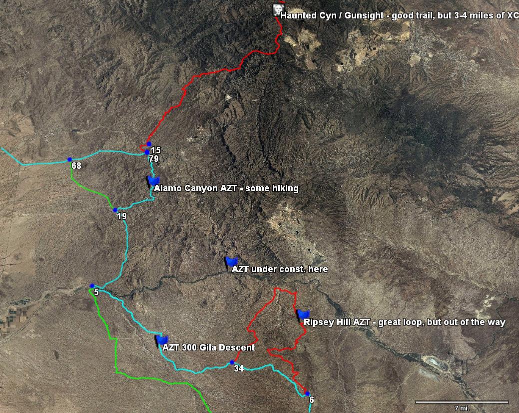
screenshot from TopoFusion
No one AZT trip has been the same. New sections are built, old ones rerouted, and the biggest question an AZT thru-rider should ask themselves is, “how much do I want to stick to the trail?”
There are two extremes of this route choice. Staying with the trail can lead to some long hike-a-bikes (but also amazing terrain). The other extreme is the route described by Andrea Lankford’s book, which sometimes follows parallel dirt roads.
The current recommendation is to go with a route that is somewhere between the Lankford route and the “trail-no-matter-what”. There are several key sections of beautiful trail that simply weren’t built when Lankford wrote her book. There’s no need to spend so much time on dirt roads.
![]() AZTnetwork-v3.gpx [12/09/13]
AZTnetwork-v3.gpx [12/09/13]
Also see the Arizona Trail Race’s GPS page, which is updated every year. Included there also are full cue sheets for the route and some water source information (though the best source of info on water sources, is from the Fred Gaudet’s water table page.
AZT Network GPS data details
The above file highlights the options available to the Arizona Trail cyclist. Each track is colored according to the following table:
| Cyan | The current recommended route |
| Green | Easier / road alternates, usually as described in Andrea’s book |
| Red | Hike-a-bike or otherwise adventurous segments for true AZT junkies |
A number of waypoints are set as notes about some of the options. There are also waypoints set at each intersection in the network. The numbers on these waypoints don’t mean anything — they are simply a byproduct of TopoFusion’s network feature which was used to combine and filter the AZT network GPS data.
Crossing the Canyon
There’s one slight hiccup for AZT bikepackers. The Big Ditch, aka Grand Canyon, presents a bit of an obstacle. It is illegal to ride bikes anywhere in the canyon, and this is aggressively enforced (famous examples include the Sedona 5 and the Riding the Spine crew).
However, the corridor canyon trails (Bright Angel, North and South Kaibab trails) are not wilderness. So, it is lawful to possess a bike, as long as it is disassembled and the wheels don’t touch the ground.
Options for crossing the canyon:
- Carrying your bike – This provides the best continuity for the trip, but it is also the most difficult. Morris and Blackwell strapped their bikes to their packs, including camping gear, and made the crossing on their 2005 trip.
- Shuttling the bike – A number of shuttle services are available to get your steed from one side to the other, leaving you footloose and fancy free to make the crossing by foot. Hiking rim to rim is an experience like none other. Another option is to get a friend to shuttle your bike across. However, this option is subject to the closure of the North Rim. The shuttle services won’t run, and the gate south of Jacob Lake will be closed until the park is officially open. The optimal weather window for bikepacking the trail often dictates an arrival on the North Rim while it is still closed (to cars, not to human powered travel).
- Riding around – This option works, and preserves the purity of “riding” the route (staying on the bike). However, to date no one has found a route that avoids significant stretches of busy and potentially dangerous riding along highway 89.
History of Cycling on the AZT
In 2000, Andrea Lankford led the first thru-ride on the AZT. Told by some that she “couldn’t do it”, she proved them wrong by cycling the length of the state with Beth Overton. The result of that trip was the guidebook, “Biking the Arizona Trail.”
In 2004, Tim McCabe ventured out to ride the full trail, exploring sections of the AZT not described in Andrea’s book, newly built ones, and ones not recommended by the book.
In 2005, Lee Blackwell and Scott Morris took up where Tim left off. They tried to stick to the official trail, and ended up exploring some interesting but arduous wilderness detours.
Also in 2005, Scott Morris was the first to time trial the trail, following Andrea’s route and finishing the 750 mile trail in just over seven days.
2006 saw the first AZT 300, putting bikepackers on a contest with the first 300 miles of trail. A race on the full distance of the trail, including the mandatory portage across the Grand Canyon, started in 2010.
The AZT was officially finished in December of 2011, though there is no official bike route. Various options for detouring around Wilderness are available, and some sections are still not recommended for bikes. The trail continues to be improved, with singletrack sections replacing dirt roads, and more bike options available.
AZT trip reports
Scott and Eszter’s 2014 thru-ride
Tim McCabe’s Spring 2006 thru-ride
Epicrider’s Fall 2006 AZT-ish journey – Utah to Mexico
Scott and Lee’s 2005 hike-a-bike thru-ride – Journal entries, photo albums, route details
Racing the AZT in 7 Days by Scott Morris (on Andrea Lankford’s route)
Trip reports here on bikepacking.net: AZT trip reports..
Another great resource of trip reports for the AZT is the AZT 750/300 results page. Click on racer names to find blog links, photos, etc.
Links
Official AZT website – JOIN the ATA and support the organization that built this amazing trail!
aztrail-build.org – Volunteer construction project responsible for 30+ miles of supremely bikepackable AZT – website now gone
The Arizona Trail 300/750 – Informal/unofficial race on the first 300 miles of the trail, held each spring.
Biking the AZT – out of date guidebook by Andrea Lankford
Scott
This looks great, along with this forum having access to all of this data will be a great asset to any one wishing to bike the AZT.
Perfect – I was in need of tracks for the Northern section.
I just moved to Patagonia. Needed this exact data for an afternoon of exploration.
Cheers,
Matt
Conditions Update: the diversion dam at the Gila River (on the AZT 300 route and the currently recommended AZT thru-route) is out of commission and is being rebuilt. Water is flowing down the main course of the Gila, so fording is now required at that spot. Depending on the water level (Gila River is controlled by a dam much further up stream) it may or may not be safe to cross. Nov/Dec the river generally runs low, but the rest of the winter it can be quite high.
Stay tuned for further updates.
[…] hope to get more details up through next week, before we leave. For now you can read about the route and check out the site for tracking the race (I’ll be wearing a SPOT […]
[…] Arizona Trail […]
[…] posted at http://www.bikepacking.net/routes/arizona-trail/ and found the forum there very valuable. There is a shuttle bus from Phoenix to Flagstaff ($50 I […]
[…] Get the AZT bike network […]
[…] me valuable information about the track in personal emails. Special thanks to Scott for creating bikepacking.net (where I got the excellent GPS tracks) and the TopoFusion […]
does the gpx file linked above work for anyone else? the only colored tracks i get to show up is a small circuit just north of tucson and that’s it. it’s otherwise a bunch of waypoints but not much else. is anyone else experiencing this? i’m attempting to view the file in topofusion…
Hey Josh — did you get my email? I think it’s a Mac / Parallels issue. The colors come up OK for me. The GPX network needs an update. I would try the AZTR route for now:
http://www.topofusion.com/azt/race-route.php
I am looking to ride from the Tuson area to the Phoenix area the last week in November. any info the weather I should I expect?? Is this a bad time????
AZT network file updated for 2013 — major update to include full Gila Canyons and San Francisco Peaks segments! Get out there!
Brandon — my reply is a bit late, but that’s a perfect time to ride on that stretch of the Arizona Trail.
Hey guys,
Great resource! Thanks for all the work that went/goes into this! I just uploaded the gpx file to my phone using the Gaia GPS app. I have a question about the color code though. I see a few more colors than just Cyan, Green and Red. I’m seeing Black, Dark Brown, Purple, Blue, etc. I’m guessing black is closed to bikes, brown is a dirt road? Anybody else seeing more than 3 colors on the track? Am I missing some glaring explanation? Thanks in advance for the clarification and keep up the good work!
Stevan — I think that the colors Gaia assigns are simply random. I wouldn’t assign any meaning to them. The app must not be reading the standard GPX coloring tags that are in this file.
I’d recommend pulling it up on a computer to get the big picture on the different options available. Then Gaia will work great once you’re out there and have studied the choices a bit.
I am a metalworking artist living and working in Tucson and I LOVE the Arizona Trail. I have been making trail related novelty license plates for over a year, these are great to put on your vehicle front or just hang on the wall. Here is one for the AZT800 miles of saweet trails (please note the genuine copper metal and “Made in AZ” stamp at lower left):
https://drive.google.com/file/d/0B7PswOIqtYKdak42ME56QWtjbThON1dRekIwcFdLTHhNQkRB/view?usp=sharing
I am working on one now for a guy in Portland which will say AZT300 to represent an epic ride he has done on the AZT.
I am making an order of 20 for the AZTrail Assoc. and am also the maker of their belt buckle finisher awards:
See a brief article here– http://www.aztrail.org/completion/survey_order.php
Get in touch with me and let me know what I can make for you! $30 each plus $5 for shipping.
Jason Butler, MFA: info@jbut.org or 520.396.0645 also simetalwerks.com
Very cool stuff Jason. Thanks for supporting the AZT and the ATA!
Hi!
I’ll be touring from Phoenix through to Canada starting in April, I’m wondering whether the section from flagstaff to Grand Canyon Village is doable on my Kona Sutra (not a mountain bike).
Many thanks in advance!!!
Hi Edward,
I wouldn’t recommend it. Out of Flagstaff it is definitely mountain bike trail.
You could ride certain portions of it when the trail itself is a 2-track. All through the Babbit Ranch segment would be good to go. But the rest I would recommend a mountain bike for.
Cheers
hello,
My name is Moshe, and i am from Israel and dream to ride the AZT.
In order to start planning the trip I have some basic questions. Can you give me some links to someone having experience in AZT by MTB.
I really enjoyed reading your description of the AZT. And may by you can give some answers.
Regards
Moshe
Hi Moshe,
Welcome. There’s a small collection of links to previous trip reports (some recent) right here on this page. I wrote a pretty detailed description of the 2014 trip I took with Eszter.
Feel free to hit me by email, or post on the forums (under Routes, perhaps) for further questions.
Scott
I cannot seem to find anywhere how many miles the hike would be across the Grand Canyon section. Does anyone have that information?
From the South rim, you can choose from the Bright Angel or the South Kaibab. Bright Angel is most commonly used, there’s water at Indian Gardens halfway down. No water on South Kaibab.
Bright Angel is listed at 7.8 miles while South Kaibab is shown as 6.3. South Kaibab is WAY steeper.
Once you get to the river, on either, it’s a mile or so to cross the river and get to Bright Angel Campground. Net distances are like 9 and 7 miles.
From Bright Angel, it’s 14 miles up to the North Rim.
Read a lot more details here: https://www.nps.gov/grca/planyourvisit/trail-distances.htm
p.s. I believe that Bright Angel is most convenient/accessible when coming in on the AZT.
If you’re looking to stay true to the AZT, the South Kaibab trail doubles as the Arizona Trail. While it is steeper & lacks water, there are two rest areas with pit toilets and the views are much better IMO. The Bright Angel trail gets a bit more traffic, but it is closer to the village if you need supplies.
Thank you for that information! I appreciate you taking the time.
Thanks for the clarification, John.
I don’t know if you have to use one or the other to meet AZT race requirements. I’m sure someone who’s familiar with the race will know.
Of course, that’s irrelevant for those who aren’t racing.
How rideable is the AZT in early December? I am looking for a mtb route south from St. George to Phoenix.
Kai,
As long as it’s not snowing, the AZT should be fine in Northern AZ. Keep an eye on the weather. It’s been warm & dry so far….
Does anyone know a viable option for getting transport back to any major city (Tucson most likely) from the southern end of the trail? Also, any other good options in traveling with bikepack gear for a few hundred miles via fossil fuel enabled transport in general? I may be doing the AZT this winter and won’t have anyone to pick or drop me off, is why I ask. I’m new to complicated travel logistics side of bikepacking. Thanks!
Check out Home Grown Mountain Biking Tours, LLC, they have experience transporting mountain bikers from various locations on the AZT and would be happy to help!
Hey, riders, thanks for all the info.
How is the signage along the trail? (Will have GPS and the ATA book.) The Colorado Trail I found thoroughly signed. Can someone compare the AZT and CT in terms of signage/navigational ease? TIA!
Mike,
The AZT is signed well. You shouldn’t have any issues if you’re using both GPS & guidebook. You may want to also consider the AZT app. It contains the bike route as well.
Many thanks, John – belatedly!
2019 ride – I’m looking for a compatible companion for a ride Feb/March or March/April 2019. I’m a 57 year old lady, I want to go slow, take time, take zeros, allowing around 60 days to complete, if necessary!
I’m not into partying, more just the beauty and solitude but am up for some banter and mulling over life.
I’ll be coming over from the UK, so could do with some help with getting to the trail head, shipping my bike bag to the end point etc, if anyone could help with the logistics, I’d be grateful.
Angela Hart — Let’s connect. I’m riding the AZT beginning April 7th or 8th, heading north for 10 to 12 days. I ride to be with nature, not much hurry. Realistically, for that trail, which is difficult, I’m looking at about 35 miles per day. I’m going solo right now, but would enjoy some company, if you would like to join. I’ve got a cousin in Phoenix who will help me with shuttling to the start, etc. I’m a 48 yr old male, don’t drink at all, very experienced in back country travel, bikepacking, camping, etc., however, I know very little about Arizona. Kind of scary to me, honestly. I’m from Idaho, USA, Pretty much the opposite of Arizona. It’s green and cold where I come from. jonathanaaronblack@gmail.com
Hi Jon, thanks for your comment, I’ll drop you an email
I always find it odd that Andrea Lankford usually forgets she didn’t do the trail alone if I was miss Overton I’d tell everyone what a egotistical ass Lankford is.
Not to worry Mary those who followed remember that miss Overton was the more experienced rider of the two. Her contribution has in no way been forgotten, Current tracker shows the girls are still getting it done even when pushing is required http://trackleaders.com/aztrspring22
I am looking for a companion to ride from the Superstition Mountains, south to Nogales next month, Nov 17- Dec 5th, 2022. Flexible return dates- flying out of Tucson to get back home to northern WA state.
Send me an email if you are interested! Bike packing experienced a must.
Kelleronnfeldt@centurytel.net