Oregon Three Rivers
Overview
The Oregon Three Rivers route showcases three of the finest singletracks in Oregon:
Middle Fork Willamette Trail (~30 miles)
North Umpqua Trail (~80 miles)
Mackenzie River Trail (~30 miles)
It’s possible to link all three of these routes, without the aid of shuttles or support. It even includes an off-highway route that can be used to get into and out of Eugene, OR. A number of singletrack options are available both between the river trails and as side options.
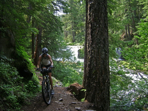
Route details
This route currently holds the distinction of being the most rideable singletrack route on bikepacking.net. The nature of trails following a river is part of it (think gradual climbing/descending). Another is just the nature of trails in the Cascades — smooth and buff.
Bikepacking on any of these trails is highly recommended for people getting into bikepacking or those not wanting to do much hike-a-bike. Downed trees can be an issue, so be sure to check locally to see which trails have been logged out before you go. Also look out for two more Oregon obstacles: poison oak and mosquitoes.
Don’t let the easy rating fool you, though, even for experienced riders this is an awesome tour.
Take the big bus
Besides the off-highway route into Eugene another great option is the Lane Transportation District’s city bus that runs all the way out to the Mackenzie Ranger Station. For $1.50 it’ll take you some 50 miles to either start out your trip on singletrack, or end it with an easy ride back into town.
GPS Data
Trip Reports
Oregon Singletrack Tour CH1 (Willamette River)
Oregon Singletrack Tour CH2 (North Umpqua River)
Oregon Singletrack Tour CH3 (Mackenzie River)
Links
North Umpqua Trail – a great site from the BLM.
Willamette Mtn Mercantile – friendly bike shop and outfitter in Oakridge, OR (on the route).
I am unable to open this ORST Full Trip.gpx file. I am looking at trying out this ride this Summer and would love any and all info I can get my hands on, is there anyway to get access to this file? Thanks!
Daniel — the file downloads just fine for me. What software are you trying to open it with? Make sure you download the file full — it’s about 2.7 mb.
Thanks, I am on the same computer as before, I will try a different computer when i have a chance, thanks
I can’t open the full trip either, would really like to see it.
Scott, thanks for posting the trip. I did a solo trip of the Middle Fork of the Willamette/North Umpqua section August 4-7/2011. Snow had just melted up at Timpanogas Lake with the only occupants being thousands of mosquitoes so I also kept riding to get away from the lakes. Hot Springs and Jessie Wright sections of North Umpqua Trail were closed at the time. Wonderful route!
What is the recommended software to open the GPS file? I would love to ride some version of this route next month! Thanks
Hi Liz. Allow me to shamelessly recommend my own GPS software. It’s called TopoFusion and used to create a lot of the GPS files and maps here on bikepacking.net. 🙂 http://topofusion.com
You can load this track into Google Earth. Just select gps(gpx) layers when you are opening the file.
Hi Scott. I downloaded the demo version of topofusion and tried downloading your gpx file onto my garmin edge. However, when I open the saved file, only 3.63 miles of the trip actually saved on my device. Do I have to purchase topofusion in order to download the entire file?
Ben, no, you don’t need to have purchased TF. It sounds like you just need to simplify the file first. Try using this guide:
http://topofusion.com/tutorials/uploading-tracks.php
Hope that helps!
Anyone here from the local area? I’m wondering what trail conditions are like currently, or if they are not good now, when is the best time to ride?
Any idea what the camping situation is like along this route if connecting the three trails? Are there plenty of camp grounds or legal camp anywhere sort of situations?
Generally it’s forest land so camping is legal along most of it. But since it can be thick woods/brush it isn’t as easy to find clear ground as you might be used to. I’ve found there to be enough options, though.
The GPX track for the Full Trip doesn’t do a complete MRT, is that by design? Stopping at Trailbridge really misses some amazing scenery and riding. Above trail bridge MRT goes all the way up to (and around) Clear Lake. The riding can be quite technical in sections with considerable lava fields, but you also get to see the Blue Pool from a couple of angles and Clear Lake is really wonderful. MRT is about 26 miles one way. It’s a pretty solid ride to do as an out and back, but I try to do it a couple times a year. Camping is in designated sites along the river. Paradise Campground is my favorite and they have limited walk in sites. But there’s quite a few options.
Be aware that the North Umpqua Trail has tons and tons of sharp climbs in both directions. You just won’t believe how much climbing it has. All 3 of these amazing trails have sections that are quite technical, so expect to do some dismounting. “Smooth and buff” by Oregon Central Cascades standards is much more textured and narrow than most other states. Buffness is assured, even in the rain.