Routes
Western U.S.A.
| Name | Color | Distance | Climbing | Rideability* | Singletrack | Start | End |
| Arizona Trail | 800 miles | 100,000′ | 5-7 | 60% | Mexico border | Utah border | |
| Coconino Loop | N/A | 250 miles | 28,000′ | 7-8 | 44% | Flagstaff | Flagstaff |
| Colorado Trail | 530 miles | 60,000′ | 6-8 | 60% | Denver | Durango | |
| Continental Divide Trail | 3000+ miles | 400,000′ | 4? | 50% | Mexico border | Canada border | |
| El Camino del Diablo | 130 miles | 7,000′ | 6-9 | <1% | Ajo, AZ | Yuma, AZ | |
| Gila River Ramble | N/A | 70 miles | 11,000′ | 8 | 40% | Kelvin, AZ | Kelvin, AZ |
| Grand Loop | 360 miles | 48,000′ | 6 | 8% | Grand Junction, CO | Grand Junction, CO | |
| Grand Enchantment Trail | 580 miles | 80,000′ | 4-6 | 50% | Phoenix, AZ | Albuquerque, NM | |
| Great Divide Route | 2709 miles | 150,000′ | 10 | <1% | Banff | Mexico border | |
| Idaho Centennial Trail | N/A | 1000 miles | 80,000+’? | 4-6 | 60%? | Utah State Line | Canada |
| Kokopelli’s Trail | 144 miles | 20,000′ | 8 | 5% | Moab, UT | Fruita, CO | |
| Kaibab Monstercross | 130 miles | 15,000′ | 8 | 40% | North Rim, AZ | North Rim, AZ | |
| Oregon 3 Rivers | 400 miles | 40,000′ | 9 | 70% | Eugene, OR | Eugene, OR | |
| Ring the Peak | 70 miles | 12,000′ | 7 | 60% | Manitou Springs, CO | Manitou Springs, CO | |
| Trans Utah | 600 miles | 60,000′ | 7 | 40% | St. George | Moab | |
| Vapor Trail 125 | N/A | 125 miles | 23,000′ | 8 | 40% | Salida | Salida |
* – Rideability ranges from 1 to 10. 1 = leave the bike home. 10 = where’s the challenge?
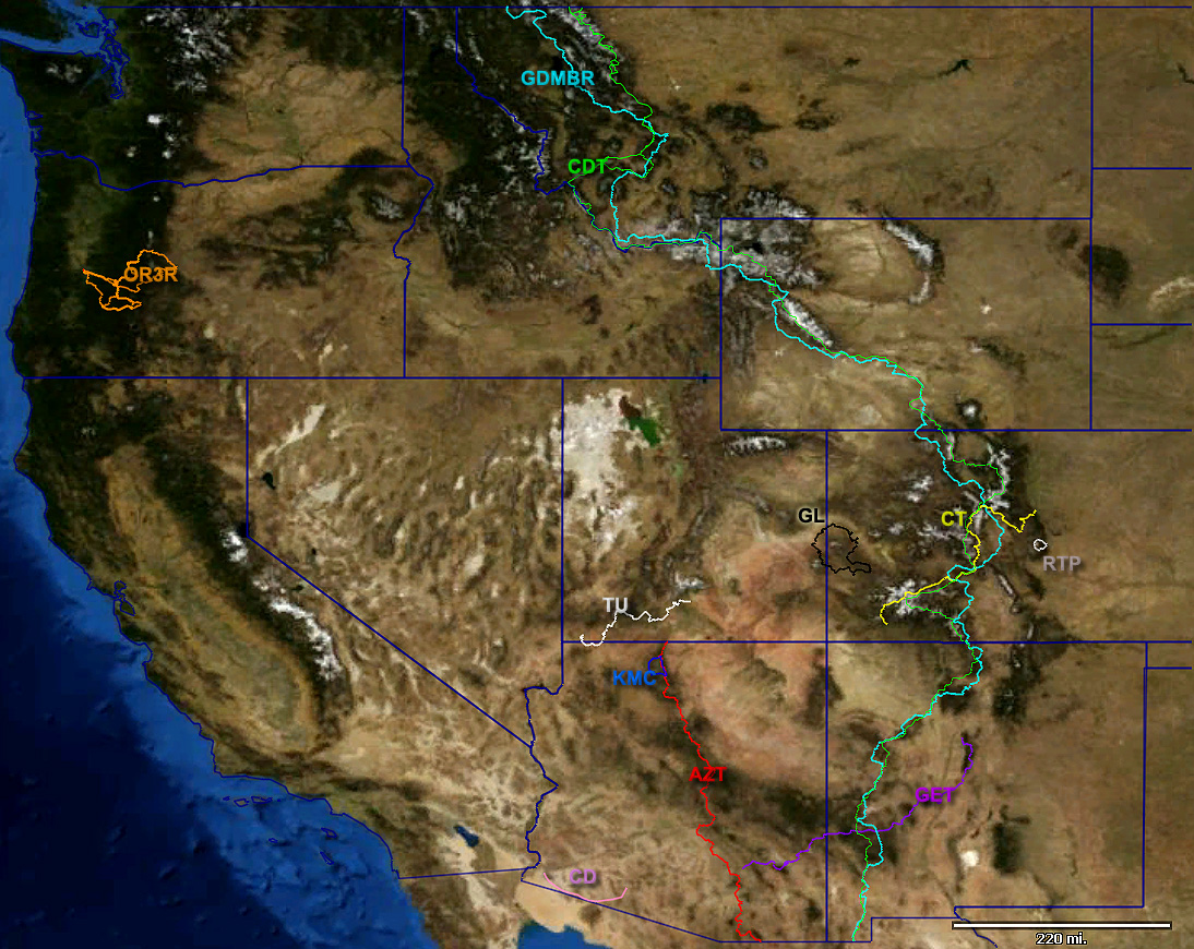
click to enlarge
See also the 3D Route Gallery
Rest of U.S.A.
| Name | Color | Distance | Climbing | Rideability* | Singletrack | Start | End |
| American Discovery Trail | N/A | 6,800 miles | ?? | 8 | <33% | Pacific Ocean (CA) | Atlantic Ocean (DE) |
| Iditarod Trail | N/A | 1100 miles | 35,000′ | 3-9 (variable) | Snow | Knik | Nome |
| Maah Daah Hey Trail | N/A | 115 miles | 8,000′ | 9 | 75% | Watford City, ND | Medora , ND |
| Sheltowee Trace | N/A | 270 miles | 10,000+’ | 6? | 75%? | Picket State Park, TN | HWY 377, northern KY |
| Trans Iowa | N/A | 340 miles | 20,000′ | 10 | 0% | Decorah or ? | Decorah or ? |
Worldwide
European Bikepacking Routes by GypsybyTrade
Pedaling Nowhere’s bikepacking routes
| Name | Color | Distance | Climbing | Rideability* | Singletrack | Start | End |
| Australian Bicentennial National Trail | N/A | 5,330 km | Unknown | 3? | ? | Healesville | Cooktown |
| Freedom Trail | N/A | 1450 miles | 130,000′ | 4-7 | ~20% | Pietermaritzburg | Cape Town |
| Tasmanian Trail | N/A | 477km | 20,000′ | 9 | <1% | Dover | Devonport |
| TransAndalus Loop | N/A | 2173km | 38,000m | 9 | 10+% | Andalusia, Spain | Andalusia, Spain |
| Transardinia Trail | N/A | 444km | 12,000m | 9 | 10+% | Olbia Sardinia, Italy | Cagliari, Sardinia, Italy |
New Routes
We are looking for route info and GPS data. If you have a route, whether official or of your own creation, email us at info@bikepacking.net. We’d love to hear from you.
[…] copies of his software. If you’ve seen the incredible mapping done for the Epic Rides , Bikepacking.net and the Arizona Endurance Series then you know the insanely cool things that are possible with a GPS […]
What about a link to the Trans Canada Trail:
http://www.tctrail.ca/thetrail.php
Looking at that map, I’d say its only a matter of time until *things* are connected into a massive Mountain West Loop.
Why is there nothing on Canada, the bike packing mecca of the world. No trans canada trail? KVR? a million others?
Why don’t you contribute then?
The quads have turned much of the KVR and TCT into a sandbox. Canadians are usually pretty good about following rules, but in this case the motorheads have decided the rules are for someone else and have taken over the route.
Any other routes out there for Europe? Maybe some Germany/Italy/Central Europe stuff? All this US stuff is great but I don’t live there right now.
Trails in Switzerland: http://www.swisstrails.ch/
How about some Pennsylvania stuff i know a 100 mile loop in western PA
Kruz, im in CT and bummed to see nothing close by, NY or PA. What’s the western PA loop ur talking about?
This site is what you make of it, so make some contributions from your local area rather than waiting for others to do it for you. Bikepacking = Exploration. It’s the name of the game, it’s not supposed to be plug-n-play. A good example is this thread: http://www.bikepacking.net/forum/index.php?topic=954.0
Well mom thanks for the advice, it appears you will be of no help then. Just lookin for a starting off point.
Cris the western PA loop is wrongly described sorry it is in State college PA in a town called Coburn where the Wilderness 101 backcountry race takes place it is in Rothrock statepark and the website is http://www.Mtntouring.com or you could google it I’m pretty sure you are allowed to camp along the trail as it is a state park the reason i am not 100 % on that is this is my first year entering the race
There is also a 36 mile loop connected with the Ghost town trail In western PA. It is a very scenic trail easy tho just rails to trails stuff you are not allowed to camp but it is very remote along the ghost town trail nobody cares if you camp anyway im a local who rides it all the time as i live about 1/2 mile from an entrance to the trail
A correction: Rothrock is a State Forest and not a State Park. There is huge a difference in what is allowed as far as primitive camping between the two. The Wilderness 101 (last I road it), goes through a number of small State Parks (Whipple Dam, Poe Paddy, Penn Roosevelt and near Poe Valley.
I’m curious to this loop route associated with the Ghost Town Trail. As far as I know, the Ghost Town is pretty linear from Ebensburg to Blacklick with a branch up to White Mill. From Blacklick you can take the Hoodlebug N to Indiana or S to Blarsville. From Blairsville you can take the West Penn Trail to Saltsburg, and from there branch N for a couple of miles before a dead end (although creative types can make it to Apollo, or branch west and pick up the Westmoreland Hertitage trail and end up at Slickville. None of that is remotely near a loop… so Kruz, where is the connector?
Chris: I’ll give you hint for something in NY… Check the Trip Reports section of this website 🙂
There are two abandoned bridges that the ebensburg mainliner had a 3 page article on saying that township was going to repair them and resurface them which they just finished about a month ago the bridges are located between twin rocks and the road going to cardiff you drive underneith them leaving twin rocks also if you start in colver turn at regan junction and keep going past the bridge in belsano you will ride right onto them it is a straight shot it is worth checking out it is as easy as ghost town trail but it has some technical parts
another thing its not on any maps yet but you are allowed to ride it its just no motorized vehicles
also Research the C&I railroad and colver history you will prob see it in your research you could just google it and it will come up
also you i forgot to mention you are correct about my mix up with the state fores/state park thing thanks for the correction
Central Europe has been working on these for a bit: http://www.eurovelo.org/routes/ though I have to say I have yet to find detailed information on the routes. I’ll be trying some of them out this summer.
Please someone list the PCT…i want more info on this trail
The rideability of the PCT is 0 (zero), as bikes are not allowed anywhere on the PCT since it has Natl Scenic Trail status. Given that, it wouldn’t make sense to list it here.
Anyone working on a PCT for mountain bikepackers? I would like to plan something out like that, maybe do a full west coast loop? Varying from easy to extremely technical? Maybe involving the Oregon 3 rivers down to Lake Tahoe or Moab, to Arizona then up the Divide???
I think someone should consider the longest continous beach costs and biking them, or making a circle around some island beach….so much potential for beach riding.
eturk
2 new mountainbiking trails in the French Alps. I rode a part of them and they are great!
GPS info can be fount on their website;
http://www.vtt.alpes-haute-provence.fr/grande-traversee-vtt-transverdon/
Nice post. I learn something new and challenging on sites I stumbleupon every
day. It’s always useful to read through articles from other authors and use something from other web sites.
Jelle, would you creatie a route page for them here on bikepacking.net? That’s how it works, we all write up what we know.
Same to others who know of a route that doesn’t have a page yet.
Working on a route from Tahoe to Lone Pine or ridgecrest.
California
I know a guy…
My friend Jim may be able to help. He knows the area well. We can discuss soon or in Death Valley.
I have a route Trans North California, we just rode it in November. I have to clean up a few spots but will open up as a race late Oct 2014. Should end up around 375 miles 32k climbing Reno to Mendocino. Facebook Trans North California
I’d be happy to answer any questions on the FB page. Ride on…
Love to see if anyone has done some bike packing routes in northern italy/dolomites? Want to head there this summer and want some beta so I can reserve some huts.
Do you have anything in north California, in Siskiyou county? North as in true north, not central–San Francisco.
posted a trip report in NorCal, Nevada City up to Graeagle, yesterday – it’s pending approval for now. Also emailed the gpx to them to put on the routes page. There are NorCal trips out there for sure!
Graeagle loop post just got approved – live from the CDT! Thanks Scott!
Can somebody explain the rideability ranking?
* – Rideability ranges from 1 to 10. 1 = leave the bike home. 10 = where’s the challenge?
What does that mean?
Is 1 the most difficult and the reason you need to leave the bike at home? Or is 1 the easiest therefore, you may as well not even bring a bike?
Is 10 the most difficult but when you are done you are left saying “where’s the challenge?” Or is 10 the easiest leaving you to say “where’s the challenge?” because it is so darn easy?
10 would be a completely rideable dirt road (such as the GDMBR).
1 would be a hike-a-bike, barely trail or cliff scale.
I am currently riding around the entire island of Long Island and NYC calling it the CLINYC (Circumvent Long Island and NYC on Fatbike by Beach and Trail) Project. I am riding mostly on the beaches, however there are quite a few trails, especially on the eastern tip of the island, many of which date back to the colonial times in the 1600’s (which are probably much older than that as they where probably utilized by native americans before). Although this is not wilderness, it is exploring and you can see the routes I have taken on my strava, through my website http://www.nwk.cc Also if anyone in the area would like to join it would be welcomed. If/when we get some snow I will do some routes on trails, and try to utilize trails between sections of beach. Most of the beach is accessible, the Picnic Bay side is broken up a bit by inlets and bulkheads but the Atlantic ocean side is like a fatbike super highway.
Hope this is useful to someone interested in beach riding.
Thanks
nwkcc
nm@nwkcc.com
http://www.nwk.cc
Maybe someday in a near future, Portugal will be listed where to!
I’m working on that!
Cheers!
http://www.bikemadridlisbon.com/
The TransCAM (Trans – Autonomous Region of Madrid, in spanish Trans – Comunidad Autónoma de Madrid), or also Transmadrileña – http://www.transcam.org -, is a circular cyclotraveling route for mountainbike which surrounds the hole Autonomous Region of Madrid to publicize the different landscapes that can be found in it.
Does anyone have info on the Trans California route/race
ITALY SARDEGNA
Very Wild 680 mile 92.000 + 85% gravel 4-6
http://WWW.NATURAID.COM
The linked text Idaho Centennial Trail goes to an erroneous location in the site.
The first Chinese Bikepacking adventure is coming …. in the northern China’s Silk Road from Ürümqi to Beijing
Grand Depart in Ürümqi 09:00 am Monday 30 July 2018!
http://www.bikechinaexpress.com/
Hello.
My friends and I are looking for a mountain bike ride/camping trip that can be supported with a vehicle. Last year we did the White Rim Trail in Utah and we are looking for a similar trip to do this summer. Internet research hasn’t resulted in any rides that fit into our parameters.
Can you recommend any rides in your neck of the woods or beyond that might be a good fit for us.
Any guidance would be much appreciated.
Sam
Sam — you might try posing this question in the “Routes” section of the forums here on bikepacking.net rather than here.
Kokopelli is one that could work. Black Canyon Trail is another. Durango to Moab route?
Cheers
Our group of friends have been doing a late season ( late Oct- early Nov) supported ride for the past five years. The White Rim has been a favorite but to mix it up, we’ve completed the Paradox Trail and the Kokopelli Trail, both epic long distant trails. This year we are looking at a Bears Ears to Moab route of about 120 miles. There are lots of potential big rides out there.
I did a few days of the following route in early September 2019, but early snowfall and bad weather scuppered my trip.
https://www.schweizmobil.ch/en/mountainbiking-in-switzerland/route-01.html
The route was amazing, but there were few campsites and Switzerland was very expensive. If there was more camping spots then it would be an amazing route.
Would like to bike pack part of the AZT starting from the north in mid May. Will have 4-5 days to ride. Son and have ridden a few segments of the CT and have experience.
We live in Indiana and would prefer to fly to AZ, rent bikes and pay an outfitter to drop off north and pick up south.
Seeking recommendations. Any information on trail conditions in mid May would be helpful as well.
Thanks