Desert Southwest (CO,AZ,UT,NM), Trip Reports » Wasatch Wanderings
This is a route I’ve been thinking about for a most of the summer. I like riding all the normal, flowy, fun trails in the area but sometimes I crave for a bit more of an adventure.
I planned on this ride taking 2 fullish days to do. My goal was to be riding at an early hour on the first day. I was on-call at work the night before and lo and behold I got called in a 3:30 in the morning. I was done and back home about an hour later and thought about just driving down to the trailhead but I knew my gracious shuttle driver wanted to sleep a little more. Totally slept through my alarm and woke at 9:30. Shit. I started my ride on day one at 11:40am. Figured I might as well still go.
The Ride Around Timpanogos (R.A.T.) is a loop described in Gregg Bromka’s guide book. It’s certainly off the beaten track and incorporates a good amount of hike-a-bike, not the easiest ride out there but fun. I rode it a few years ago and had a good time.

A few hours into day one, west side of Timp. Rolling through the grass(trail) I managed to hook up my front wheel and got tossed. Seems like that would be ok in tall grass but my hip found a rock and landed square on it. Ouch. The grass was so thick it took me a while just find what I landed on.

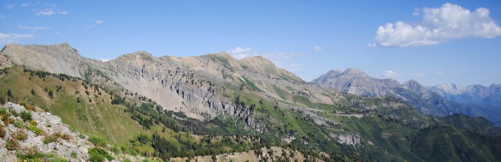
Looking up at the West face of Timp make things better.

Lots of overgrown trail out there
I remember a while ago, Trackhead mentioned something to the effect of doing a R.A.T. and a Ride Around Cascade, the next peak south of Timp, in a day. Sounded hard and cool. Up until recently I hadn’t thought much of it. I found myself looking through Bromka’s book at other rides in the area and saw that there was trail that linked up. There was no info in the biking book about it, just a line that connected a few trails. That was the extent of my research of the trail. Should be good to go right?

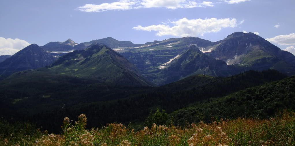
Cascade comes into view along with Squaw Peak road on the right. From one vantage point I counted 9 switchbacks on the road. That shouldn’t be too bad.

Looking back at the north end of Cascade and the South end of Timp separated by Provo Canyon. The road sucked, a few miles of pavement in the sun followed by a few more of gravel.

Evening storms to the west over Utah Lake

Y Mountain from the top of Rock Canyon

The mystery trail from the book goes to a pass in the upper left. I expected a lot of hiking and I got that. About 30 minutes into the hike it started raining pretty hard. There was only a little bit of daylight left so the decision to camp for the night was easy.

Cleared out a bit for a blazing sunset

Slept through my alarm again, do we have a theme now? Was on the trail by 7 though, I knew it would be a long day. My goal was to go up and over the ridge, roll back to Provo Canyon, up past Sundance to the 157 trail and take that to Alta/Brighton and then ride the Wasatch Crest trail into SLC and end at my house. Sounded doable, maybe.

About a 2 hour walk up under Freedom Peak to start the day. Cool area, not much was rideable though.

Almost to the pass and its rolling.
On the pass looking at what I have ahead of me. The idea was to reach the peaks at the far right and then keep going.
I reached a fork just before the pass and decided to go right. Both trails ended up at the same spot more or less. Not sure what left would’ve looked like bit this is what right looked like.

That’s the trail. What you can’t really see in the pic are the loose baby heads and logs and shit.

All that road climbing and hike-a-bike culminated in this bushwack of a down hill. There was no trail but there were carsonite sign posts with arrows to follow. I was pretty bummed by how awful the trail was and by how long it was taking me to get down. Dreams of carving down the Crest kept me going.

Eventually it hooked up with a regularly used trail and finished with a nice downhill section and then some road down to water. 4 miles of downhill road never felt so good
A bit of a road/trail climb brought me to some buff American Fork Canyon singletrack. South Fork Deer Creek downhill was ripping, ahhh. Back up to 157 and then another hour of hiking.

Timp looking all spaceship like ready for launch.

My tricked out hike-a-bike shoulder pad

Looking back where from I came, kinda near the snowy patch left of center.
The top of the 157 hike has a nice spring and is followed by some of the best trail in the Wasatch.

I was feeling really good up there, so good I thought I would take a pic of myself.

Looked a lot worse than I felt, ha.

Here we go!

Shred fest for a few miles. So nice
Then I reached the last big hike of the ride. I had never done this section but heard it sucks.

It was pretty much in line with the other hikes I had done already, the problem was the huge false summit right in the middle if it. That hurt. It was taking a while and I was coming to the realization that I wouldn’t be at the Crest by night fall, no big deal.

Wishing my camera was better

Catherine’s Pass. Snowpack eye-opener.
I wasn’t motivated enough to ride the Crest in the dark with lights and I had plans for the next morning so camping was out. And I was pretty much out of food, I know, excuses, excuses. I was feeling really satisfied that I had just completed the hardest day I’ve ever spent on my bicycle and decided I was done. One more fun techy downhill to go. I called my ladyfriend from the pass and asked for a ride. She had shit to do so I rolled down to Brighton and then cruised all the way down the road to the Porcupine for a Burger and Beer then got a ride home. BCC road sucks but it’s an easy way to end a 13 hour day.

Awesome photos, and a great idea for a trip. That’s tough terrain for bikepacking (I know it well) — unless you’re happy to be pushing a bike, and it seems you are. Thanks for the post.
nice. used to spend time out that way for work and always found it beautiful. would love to get back with a bike – road or mt. so much cool terrain. have done some trail running around guardsman / up over to park city. good stuff.
Great write up, amazing photos, you don’t need a better camera.
That was excellent. Great pics.
Thanks for posting. Nice pics. Your HAB pad is a great idea.
Great write up. What’s up with the parallel grading on that mountainside? All the equidistant road grades?
Terracing for erosion control. It’s pretty common in the area
I believe that the grades are actually the remnants of stable shorelines from ancient Lake Boneville. You can see them all over the Wasatch in areas of scree or gravel. That would be one hell of an erosion control project.
The terracing was all done by hand in the 40’s and 50s by the CCC (Civilian Conservation Corp). During that time sheep and cattle grazing were completely out of hand in the Wasatch, and erosion was a serious issue. It was indeed a massive erosion control project.
Sounds like a fun trip. I’ve done much of the trail you describe, but not connected. Thanks for sharing.
Great trip – you can’t beat the porcupine for a good burger !