Routes » Gila River Ramble
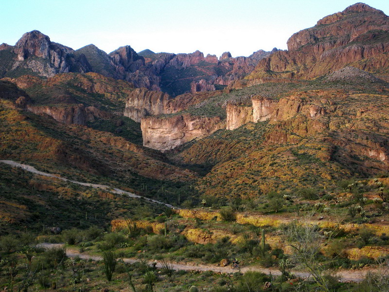
The Gila river runs between Kelvin and Florence, cutting through some of the most amazing country Arizona has to offer — from rhyolite cliffs to deep saguaro studded canyons, singletrack to freeride rock mesas and brutal roads. This loop has a little bit of everything, using an incredible stretch of the Arizona Trail as its backbone.
At around 100 miles, this route is perhaps doable in a day, but don’t let the mileage fool you. There is over 10,000 feet of climbing and plenty of slow riding. It is best done as a three day bikepack. Maybe four to really take it in.
GPS Data
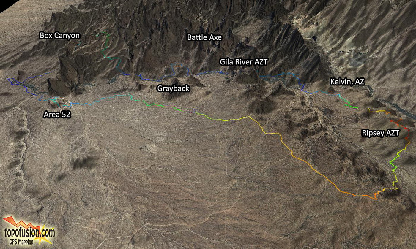
3D image from TopoFusion software – click to enlarge
![]() Gila River Ramble 2018, recommended core loop, version 1 [updated 3/02/2018]
Gila River Ramble 2018, recommended core loop, version 1 [updated 3/02/2018]
![]() Gila River Ramble 2018, area Network, version 1 [updated 3/02/2018]
Gila River Ramble 2018, area Network, version 1 [updated 3/02/2018]
Route Notes
Overall the riding is rugged and technical at times. Full suspension mountain bikes are the best choice if possible.
The core loop is a 110 mile figure 8 that starts and ends near Kelvin, AZ at a large trailhead. The ride can easily be shortened by skipping the northern loop. That also cuts out the resupply option in Superior.
A few reliable water sources are shown as waypoints. Others may exist in wetter times, such as a flow down Box Canyon.
There are two short alternates in the core loop GPX:
LowWater_Ford_Shortcut: Fording the Gila River with a bicycle is generally not recommended, but is sometimes possible. The river is dam controlled. November->January the flow is usually low, making crossing easy — this can seriously shorten the loop on the west side. Most times of the year, however, and especially in the spring, the flow is swift and deep. Check the USGS streamflow gage at Kelvin. Over 200 CFS is not recommended. If the river is low, this shortcut route can be taken to chop a number of flat road miles off. Know that the shortcut is also overgrown and not heavily used!
Area52_Adventure_Route: Area 52 is a rock mesa that can be an adventure in itself, for those so inclined. There are no trails, however, and a guide is recommended. The Area 52 Alternate track follows a moderate route through some of the lower lines, but Area 52 can also be bypassed completely by taking the 4×4 road just north of the mesa as the main track does.
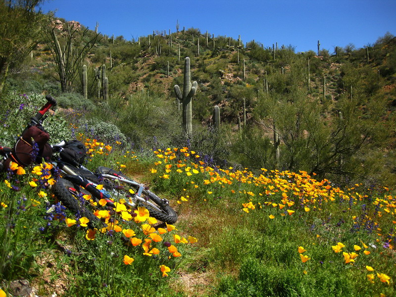
Spring (late March into early April) is the prime time to do this loop. This area typically has some of the best wildflowers in Arizona. But generally the season is October to April. The rest of the year is quite hot and these are low AZ elevations.
Trip Reports
Desert Warmth, 100 mile version, a love story with Eszter Horanyi
2010 Gila River Ramble Trip 1 by Scott Morris, with Lee Blackwell
2010 Gila River Ramble Trip 2 by Scott Morris, with Chad Brown
I’ll probably be doing this solo so I’m wondering about cell reception out there. How about the SPOT locators? Never done any bikepacking in the desert so this shuold be interesting. Your pics are just fantastic!!
There is some cell reception out there. Surprising given the remoteness, it’s usually not too hard to find a signal somewhere (verizon). SPOT of course works everywhere.
Thanks for the compliment. Flowers aren’t going to be as good this year, but we just got another storm so hopefully things will start getting green out there soon.
Can’t wait to do this again…
GPX file has been updated with a route around the Ashurst-Hayden diversion dam construction site. It adds quite a few miles to the route, but it does work. We are working to see if anything better exists, since it seems that the whole area around the diversion dam is unlikely to reopen to the public, even after construction completes.
Looking forward to next year when the AZT should be near complete in this area, which should seriously enhance this loop.
Has this been repaired? Can a vehicle cross this bridge?
Some known water sources:
Latitude: 33.01988 Longitude: -111.023718
33.036966, -111.154063
33.048797, -111.049580
33.066876, -111.033010
33.056225, -111.045417
New 2013 GPX files added — with the full AZT through this area, and fording location for low water. Also includes ice cream loop to Superior, with LOST (Legends of Superior) route, off highway from Superior to the Picketpost. There’s so much to see and do in this area, and the time to head out there is NOW!
Despite the rain, we had a great time on our Gila Ramble:
http://www.whileoutriding.com/arizona-trail/bikepacking-the-superstitions-az
[…] Scott Morris for scouting the loop and making following the route easy. And especially to Gary and Cass for the company. Check out Cass’s trip photos and words […]
Is CCW the best direction? Thinking about doing it soon.
Dan and I just did this loop- so good! Thanks for putting this together and for the maps, GPX, etc.
As far as water, the seep at 33.1920, -111.1364 was dry but the livestock watering hole, where the AZT meets the jeep road, was great. There was also trail angel water at the junction of N Telegraph Canyon Rd and the AZT and a large pothole right off the road further down Telegraph as you approach town; tank at the base of Peg Leg Rd and at southern end of route at 33.0195, -111.0238 were all good. Excellent beta and exceptional route.
trying to piece a loop together and have a few questions- hoping to ride Picketpost to Picketpost via the Ramble route and AZT:
1. From Picketpost is it possible to connect to the Ramble route and Box Canyon via the Orphan Boy/ Ajax Mine/Cottonwood Cyn/Box Cyn? On TF it sure looks like it would work, but not sure about private property, etc. IF this would go, my plan would be to descend Box Cyn on Ramble route, cross river (?), over Ripsey and then AZT back to Picketpost.
2. I still feel unclear on what the river crossing situation is. Can one legally follow the track on the 2013 GPX track on this page and cross at the gauging station? If not, how are folks crossing. I would prefer to just ford at the indicated ford spot on the GPX track, but my dates are in April and not sure how raging the Gila will be then, but presume from what I have read that fording would not be a likely option at that time. Is there a non-fording legal option any longer?
3. IF this loop could go, does anyone have an opinion on best direction to do it in? Not sure if better to ascend on the sweet AZT and descend Box, or vis versa? Thanks, bd
Hi BD,
1 – Yes, you can get to Box Canyon from the AZT using Orphan Boy/Ajax/Cottonwod. No issues with private land on that route.
2 – As best as we know, you can get across at the gauging station following the track as posted. It’s a number of extra miles, but perhaps better than taking a swim with your bike. You can check the USGS gauge online in April, but likely it will be too high to cross.
3 – I’d vote CCW, so you have the good direction on Ripsey, and option to do A52. I like climbing the AZT up to the inner canyon because you end up spending more time up there and don’t rush by the views.
Hope that helps.
Gauging station crossing should be good to go, it was fine last spring and every other time I’ve been down there. There’s also an auto bridge only a few feet downstream that would work as well.
Here’s the water flow link for the Gila at Kelvin (this gives a good idea of the fording options)
http://waterdata.usgs.gov/az/nwis/uv/?site_no=09474000&PARAmeter_cd=00065,00060
For reference, I’m 6′ 2″ and at 150 CFS the Gila was mid thigh deep, 40 CFS was just over ankle deep. 200 may be my cutoff, but I’ve yet to be down there for that kind of flow. I see the river recently topped out near 1000 CFS!! No thanks.
Thank you very much! Looking forward to it, and will try to post-up afterwards (I am famous for dropping the ball on that). Peace. Out.
We’re looking at doing the 80 mile loop in a few days and have a few questions, as we’re pretty green in bikepacking (experienced in backcountry travel)
Best spot to start near Kelvin?
Water: 2 stops, I’m assuming this is for the southern portion of the route since the portion to the north follow the river. Any reason not to use the river for water needs while by it?
So here we are, April 2017 and I am still confused how one crosses that damn river. Will be out there April 9th-12thish so the water will be running good. Cross at the dam? ride the tracks through the tunnel and across the trestle? what’s the word these days?
The best thing to do is follow the ‘recommended core loop’ route as posted here (2013 file). This will get you across the river in times of high flow… which is generally every month except Nov/Dec. Only in those months is fording the river to shorten the loop a viable option.
Enjoy it out there. Flowers have been good this year!
Has anyone ridden Picketpost trailhead – south tonthe river, camped and then ridden back out and back? Looking for a 1-night maiden voyage and any advice would be very much appreciated!
Rick,
Yeah, that’s a popular ride, both as a big day ride and an overnighter. 21 miles each way, but those aren’t easy miles!! It’s getting a bit toasty out there now, so unless a cool front moves in soon, you may want to wait until the fall to ride it. I have plenty of ride reports on the blog for that area.
I gave the GPX files an overhaul. These 2018 files should be good to go, just in time for Gila and flower season to get rolling!
The LOST trail was removed on the north (road now). Core loop now crosses the river on bridges for both crossings. Area 52 is included as an alternate, as is the west side river ford shortcut.
Hoping to get out there myself this spring. Cheers!
Is the trail too rugged/technical for a rigid 27.5+ bike? Really looking forward to riding the first week of March 2019.
KWABBOTT: If that’s what you’re used to riding, you’ll be fine. Wildflowers should be fantastic this year, they’ve been blooming for over a month!!
JOHN: Thanks for the info. Can’t wait to see those wildflowers! Instead of shipping my bike I decided to rent the 29+ ECR from the Bike Cellar. I little more rollover can’t hurt and it’s cheaper than shipping my own bike and adding tougher tires. Only concern is that we don’t have such rough terrain here in Michigan and I don’t ride rigid except in the winter. Hopefully I won’t feel too beat up at the end of the day.