Routes » El Camino Del Diablo
History
El Camino del Diablo – The “highway of the devil” – so named from the original 1540 expedition commissioned by Francisco Vasquez de Coronado due to the hardships encountered. The route lived up to its name during the 1849 gold rush. Some traveled during summer to avoid Apache marauders, and they paid the ultimate price in 120 degree Yuma heat. Historians estimate from 400 to 2,000 people have lost their lives on the Camino, meaning that it is the most deadly immigrant trail in North America.
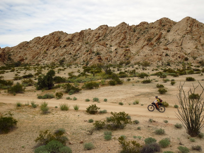
The route once linked Caborca, Mexico with Yuma, AZ. The modern version (after pavement) of the Camino starts in Ajo, AZ and ends in Yuma, AZ. It’s occasionally run in 4wd vehicles, but this route makes a good bikepacking route, provided you are prepared to deal with a little SAND! Enter fatbikes!
Permit Information
The Camino Diablo route enters the Cabeza Prieta Wildlife Refuge. A permit from the U.S. Fish and Wildlife Service (Cabeza Prieta National Wildlife Refuge) is required to travel on the refuge. You can obtain the permit at the Wildlife Refuge office in Ajo, AZ. You also need to call a number to inform the Goldwater military range that you are entering the Camino. They can explain it all at the Wildlife Refuge office — you just have to hit them when open. You can also obtain permits by mail.
See: http://www.fws.gov/refuge/Cabeza_Prieta/visit/permits.html
Water
If you ask any federal employee they will likely tell you there is no water available anywhere on the Camino. However, occasionally either of Papago Well and Tule Well may have functioning faucets. Also the Tinajas Altas (high tanks, just off route and near the Yuma side of the Camino) are very deep and almost always have rainwater stored, though it is not fresh. In general it’s best to carry all you need, and treat any you find as a bonus.
Border concerns
The Camino travels very near the US/Mexico border, so both border crossers and smugglers may be encountered. The border patrol runs regular patrols along the Camino. Border issues are no reason to not travel the Camino, but definitely something to be aware of.
GPS Data
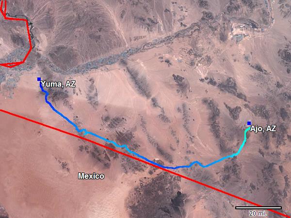
![]() Camino Del Diablo – Ajo to Yuma
Camino Del Diablo – Ajo to Yuma
![]() Camino Del Diablo – Wellton and Tacna Loop
Camino Del Diablo – Wellton and Tacna Loop
The Camino through the Cabeza Prieta is almost entirely hemmed in by Wilderness on both sides, so the route options are limited. However, there is a loop that can be done by branching north to Wellton, following the I-10 frontage road to Tacna, then continuing back to the Camino via a quite sandy road. That loop could be done on its own, skipping Ajo completely and giving water resupply at the Tinajas Altas. Though a complete passage of the Camino is a worthy goal as well.
Trip Reports
Fatbikes on the Camino Diablo
The Highway of the Devil – supported trip
Links
Fish and Wildlife site on the Camino
4×4 now’s trip report
Nice site on the Cabeza Prieta Wildlife Refuge, including permit information
I took a four wheel drive and spent two days in this beautiful desert traveling the devils highway. It was worth my time and efforts. The history and humans that died traveling this trail in wagon trains is a true test of humanity and resolve. Tread lightly we only have one desert.
Ted…
Updated page with new info on permits, water, and new GPS data on the Tacna/Wellton loop.
This is a fantastic route for fatbikes!
Thanks for this resource Scott. Rode it a couple of weeks ago, had a good time. Good water at Papago and Tule Wells, and water still in the lower tank at Tinajas. Write up at
http://mikesrideforcleanair.blogspot.com/2017/11/el-camino-del-diablo.html
I just finished this route yesterday so here is some updated info. You can park for free at the refuge office in Ajo. They have a particular area they want you to park in and also bring a copy of your Goldwater permit to leave on your dashboard.
All the wells had functioning spring loaded hose bibs. There are also two or three “humanitarian” water drums, all before Tule Well. The only water source between Tule and Yuma is the High Tanks. I believe there was a sign pointing to the High Tanks but it wasn’t there or I missed it. I had plenty of water so it wasn’t an issue. If you are counting on the High Tanks get good location info before you head out.
There was a lot of Border Patrol activity which made sleeping difficult. You are restricted to camping close to the road so expect to be woken up several times a night by trucks racing by. My theory on camping near the border is to camp in the open so it doesn’t appear you are up to anything and also criminals are less likely to give you a hard time when you are so exposed. The BP guys never stopped at one of my camps. I did speak to them several times on the road and they were most interested in making sure I was OK.
To say this route is sandy is an understatement. There was one section just west of the refuge that I had to push a mile or so and I have 4.8″ tires. According to a wildlife officer I spoke to trail conditions change frequently.
There are times on this ride when you feel like you are riding through a perfectly curated botanical garden. The night skys are amazing. One night there was even a laser show over on the bombing range which was something to see. Whatever they were doing over there was quite a display.
I did the ride in 3 1/2 days, I am slow. I stayed in the Comfort Inn on the north side of I 8. The let me leave my bike and gear in their office this morning and I hitch hiked back to Ajo and picked up my truck.
If you are in the South West and have a fat bike, this is a must do ride.
Winter 2020-21: Sand on the route was almost non-existent. Loaded bike with 3″ tires and not even close to dismounting anywhere. A lot of the route has been either driven extensively or improved for the infrastructure work nearby. Note there was a fair amount of precipitation preceding our ride. The usual water resupplies were good aside from High Tank.