Routes » Coconino Loop
Overview
The Coconino Loop seeks to highlight the best of Northern Arizona mountain biking. From buffed singletrack among the pines of Flagstaff to technical red rock Sedona country, this ~250 mile loop is a grand tour of Coconino Country.
Route overview
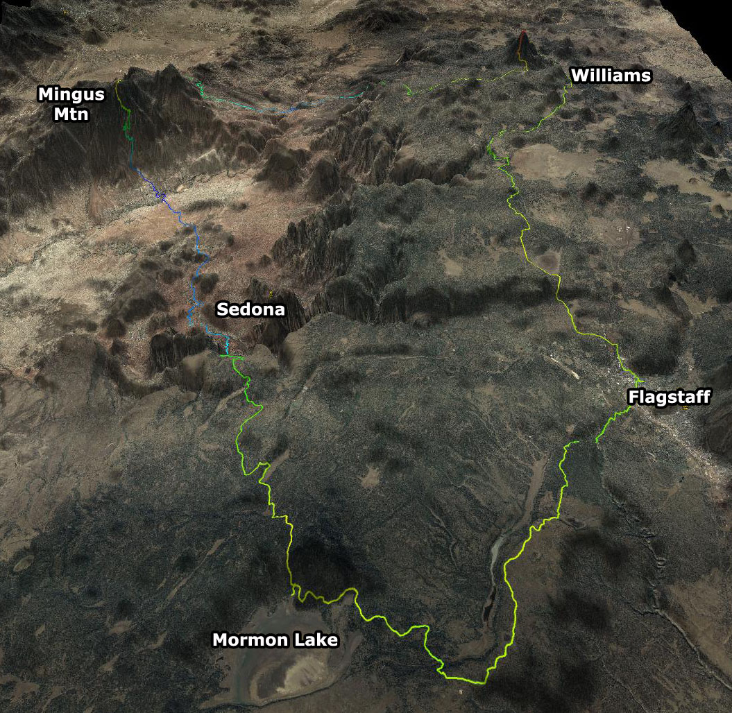
Starting in downtown Flagstaff, access to singletrack is not far. Urban bike paths lead directly to quality Arizona Trail singletrack. The AZT navigates through the labyrinth of Walnut Canyon, traverses Anderson Mesa then wraps around the perimeter of Mormon Lake. After some 40 miles of AZT, the Coconino Loop follows forest roads to descend into Sedona along Schnleby Hill, first on a dirt road, then on technical singletrack — the Munds Wagon Trail.
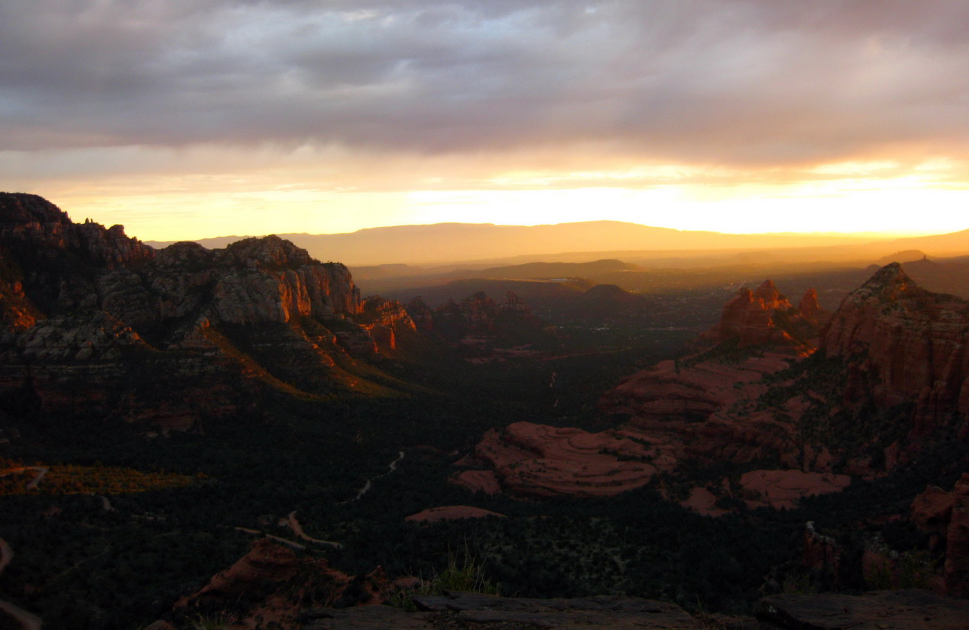
Food and mystical curiosities can be found in Sedona. The route rides through town briefly before resuming singletrack with stunning red rock views and plenty of technical challenges. Nearly non-stop trail leads out of the Sedona area to a historical trail, Lime Kiln, that links Sedona and the town of Cottonwood.
Water up in Cottonwood, then ready yourself for the hardest part of the route — attaining Mingus Mountain. Mingus is not that massive, but the climbing is steep, first on graded roads, then 4×4 then singletrack. At the top imagine flying off the mountain at the hang glider launching ramp, but instead launch off the back side of the mountain on the wild and wonderful Yaeger Trail.
Here the route joins the Great Western Trail, passing a nice spring and following a railroad grade around the backside of Mingus before dive-bombing into the Verde Valley. The Verde is a solid water source and also the low point of the biggest climb.
It’s (nearly) all uphill to Bill Williams Mountain, at 9000 feet. The last 2000′ feet of the climb are on singletrack that is well graded, full of switchbacks and surprisingly rideable. What goes up must come down, and the down on the Williams Trail is an absolute hoot.
Forest roads link the route from the tourist town of Williams to the technical Sycamore Rim Trail. Views into Sycamore Canyon are great, if you can keep your eyes off the demanding trail.
Finally, the route passes by Wing Mountain, sampling some ‘brapp brapp’ moto trail fun, then wraps things up on some classic Flagstaff singletrack, dumping you back in downtown Flagstaff.
~235 miles and 28,000′ of climbing
The route in five minutes
Touring the Coconino. from lacemine29 on Vimeo.
Credit to Mike Curiak for the photos/video, from his fall 2010 tour.
Trail type
Every effort was made to maximize rideable singletrack on this route. There is still a fair amount of dirt road riding, but over half the time is spent on singletrack, and hike-a-bike is pretty minimal, especially compared to other classic bikepacking routes.
Mingus Bypass Alternate
The Coconino Loop is one of the most rideable singletrack bikepacking routes out there. That said, the push up Mingus Mountain can be a bear. New in 2010, there is a GPX for the “Mingus Bypass” that circles around the south side of the mountain, first on dirt roads, then on a very rideable trail that rejoins the main Coconino route just in time for the Yaeger descent.
See the GPS data directory to download the Mingus bypass GPX.
Racing the Coconino Loop
Arizona Endurance Series puts on a “concurrent individual time trial” style event on the route. 2009 is the inaugural race along the route, also introducing the first self supported stage race format. For more on the race see the AES website:
http://rockyroad5050.wordpress.com/5-coconino-250-and-350/
GPS Data
The Coconino Loop from bikepacking.net’s 3D route gallery
See TopoFusion.com for full GPS data on the route:
![]() http://topofusion.com/GPX/CLR/
http://topofusion.com/GPX/CLR/
Trip Reports
Chad Brown’s Record setting individual time trial in June 2010.
Dave Harris’ writeup on his late season Coconino Loop ITT
Scott Morris’ journal of the first exploratory bikepack on the route.
Chad Brown’s report on the same trip
Looking forward to riding it again!
cool!!!!
thanks for the detail dude.
Added info on the ‘Mingus Bypass’ route (skipping the hike-a-bike), also added a couple links to recent trip reports / ITT’s on the route.
Look for an article in the next issue of Tail Winds about this fine route…
wow. The Mingus Bypass sounds like a SS dream come true.
Me and My Buddy are planning on doing this in may 2012.. Any tips or help is appreciated
When in may you looking to do this ride?
[…] Coconino Loop is a 250 mile bikepacking journey linking Flagstaff with Sedona, Cottonwood and Williams, via the […]
[…] you definitely need a GPS for this ride. All the relevant info can be downloaded from the bikepacking.net. I used my lovely new Garmin Etrex 20 (thank you Nancy!) and though I have yet to unearth all its […]
Is this route too hot for summer months?
[…] going to use some trail data that was part of a recent Ask the GPSGeek e-mail inquiry, the Coconino Loop. The .gpx files I used can be found by going to that page, or by going directly to their repository […]
Sounds like a great route! great article- thanks for sharing!
Is there any difficulty with snow in early may?
Most years the majority of the route should be fine in early May. Worst case you may need to skip Bill Williams Mountain (easy to bypass, just stay on the road into Williams).
The route is doable in the summer, too. You just need to be careful from Sedona to Mingus. The first time we rode this loop was in mid-June.
Any permits needed?
Just rode the Coco 250 route finishing on 3/29/16 and here’s a few comments I’d like to share. Lucked out having pretty awesome weather for the first 3/5 days of my ride. Red Rocks Park now charges $4/person, not $2. Mingus is a MOFO of a climb:) Where comfy shoes; no MTB race shoes. Some snow along N switchbacks on Mingus still, but I could walk on top of snow, barely sunk in. Nice campsite w/fire ring just on other side of fence at end of FR111 when you go down Mingus and ride through a recently cleared Pine section. Noticed quite a bit of downed trees all along AZT and a few up that Williams Mtn singletrack. Weather system started moving in on 4th day and I encountered lots of cool wind when I rode from Verde River Bridge up to Pine Flats and all the way up Williams Mtn where it was 44F & 40+ mph winds. Aerials were howling pretty good. Bring a solid wind/rain jacket if ya go this time of year and several clothing pieces for layering. Trail up Williams Mtn was dry but snow was in ditches near summit. Next day awoke to dropping temps and spotty snow showers, gusty tail winds. Temps continued to dropping through morning down to 38F, winds prevailed, and partial sunny skies/spotty snow showers followed me back to Flagstaff. Fun route. Fun singletrack. Take lots of pics and enjoy your ride:)
Oh my! I want to do this. Anyone know how much traffic crap there is to deal with between Flag and Sedona? Is there any road riding? Also, what is the water situation, i.e.: how often can you refill/ how many liters do you need on the bike?
Any insight is much appreciated. I’m in nursing school and starting to go stark crazy and craving a type-2 fun adventure on my bike!
-Lauren
I’ve done this route twice as the 4-day stage race. Here are both blog entries, first one has more pics, but there are still plenty in the second!!
2012 Coco250 – http://schillingsworth.blogspot.com/2012/10/aes-coconino-250.html
2014 Coco250 – http://schillingsworth.blogspot.com/2014/10/coco-co.html
As far as traffic between Flag & Sedona, there’s a little bit of town riding at the start, about a mile or two. You’ll be on AZT down to the Mormon Lake area, then graded dirt roads to the Sedona overlook. Hardly any traffic out there, but you’ll see a few vehicles on Schnebly Hill rd.
Water is readily available on route. Bring a filter though. The biggest push is from Cottonwood up Mingus and down to the Verde River. I ran a 100oz bladder + 2 bottles. I also tend to pack a Gatorade, can of Coke, etc as well. Of course this depends on temps during the ride and if you tend to drink a ton on average. I may be slightly below average in water consumption being well acclimated to desert riding conditions.
How is cellphone reception on the route?
Anybody done this in reverse? (Counterclockwise?) Any reason not to it in this direction? I’m riding it in third week of October and wondering if this might be a good option to the norm.
Thanks,
Adam H
Looking to ride this October 18-22 2017. Also considering riding it in the counter-clockwise direction. Anybody have any thoughts on this? Bad idea?
Hey Adam,
Personally, I wouldn’t ride it CCW. The route just seems to flow better CW. There are a few major portions of the route that I’d be really bummed about doing the opposite direction. For instance, you’d miss the fantastic downhill finish on the AZT into Flagstaff, you’d climb that trail and be rewarded with a tame forest road downhill. Sycamore Canyon & Gill Williams Mtn are probably a wash. Mingus on the other hand, you’d be climbing all the fun downhill trails for the payoff of downhill HAB more than likely. At least doing the HAB up Mingus going CW you get the super rad downhill. The Sedona proper trails would be fine, but then you’d be climbing up Munds Wagon Trail instead of enjoying a long techy downhill into town. The stuff from the Sedona overlook into Flagstaff would be fine, but mush more anti-climatic than the Snowbowl downhill. Just my .02.
My friend and I are planning to do this route in Late May this year. Two questions.
1. What are the coldest temperature we could expect?
2. Where do people generally park their car? Is the parking free?
Thanks!