GPS / Navigation » Garmin Dakota 10 and Dakota 20
Outdoor navigation meets touchscreen simplicity in Dakota 10. This rugged, palm-sized navigator boasts touchscreen navigation, high-sensitivity GPS with HotFix™ satellite prediction, and a worldwide basemap in one affordable, power-packed punch.
Touch and Go
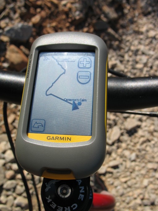
Dakota 10 makes outdoor navigation effortless with a tough, sunlight-readable, 2.6 inch color touchscreen display. The interface is easy to use, so you’ll spend more time enjoying the outdoors and less time searching for information. Both durable and waterproof, Dakota 10 is built to withstand the elements: bumps, dust, dirt and water are no match for this rugged navigator.
Display resolution, WxH: 160 x 240 pixels
Display type: Transflective color TFT touchscreen
Weight: 5.25 oz (148.8 g) with batteries
Battery: 2 AA batteries (not included); NiMH or Lithium recommended
Battery life: 20 hours
Waterproof: yes (IPX7)
Product Link: https://buy.garmin.com/shop/shop.do?cID=145&pID=30926
Please rate this product: (no login required)


 (22 votes, average: 3.82 out of 5)
![]() Loading ...
Loading ...
Normally, I don’t buy first generation electronics. But a little research showed that Garmin had come out with a new line of GPS units that used some of the attributes of the Colorado and Oregon lines. Some of the biggest complaints were the display readability on those devices. The research showed that they may have corrected this issue in this line. So I got one. A simple device, but it has a ton of memory and the display is not an issue to me. Bright and readable in direct sun, nice handlebar mount and very quick software. No problems with the touch screen – I think they have that pretty well nailed.
But, then again, I am comparing it to an Magellan eXplorist from a few years ago.
I think this is a great cycling GPS.
How does it serve for regular bike computer functions?
The Dakota 10 has all the normal functions of a regular bike computer (clock, time, distance, speed, avg., max., total odometer, etc.), but it’s incompatible with Garmin’s cadence and heart rate sensors. The Dakota 20, however, is compatible.
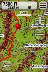
yeah – that screen shot I put up on the review is a topo that is not a Garmin product. Is topofusion able to download aerial photos to this unit?
Altimeter?
Dakota 20 has an altimeter and electronic compass. The 10 does not.
BTW, TopoFusion does upload maps to the Dakota now:
http://www.topofusion.com/news/v3-95-released-tiled-kmz-support-for-oregondakotacolorado
I posted a lengthy review of the Dakota 20 over on my blog:
http://www.topofusion.com/diary/2009/12/16/garmin-dakota-20-review/
4 stars from me.
im new to bike gps and i am thinking of buying d10… can i get turn by turn directions… or is that separate.. i do a lot of road cycling. and cant be bothered with paper maps. cheers
I have been riding with a Dakota 10 this spring and will be taking it to france for a 900 km bikepacking trip. I’m really pleased with it—easy to read and work while riding. The route in france is a newly marked pilgrimage trail from Italy to Arles, and while the trail has preliminary marks, there is no guidebook or map available. I got the sketch maps from the trail designers, put it into google earth, and then into the garmin, so this unit will be essential. So far, I think it is up to the task.
I would probably go for the Dakota 29 if I were to buy one, simply because there are a lot of cheap map packages on ebay in the sd card format.
Im abit confused with the add on maps, looking into buying one of these for a bike packing trip to france. Do you have to pay for the new maps or can i just upload the GPX file to it and follow the route from the base map?
Need advice on this people 😀
I previously had an Etrex 30, but MUCH prefer the Dakota 20 I have now. Much easier to operate the touch screen when riding.