 Topic Name: Two big New Mexico Bikepacking Routes - wanna help me chart and ride them? Topic Name: Two big New Mexico Bikepacking Routes - wanna help me chart and ride them?
|
on: April 13, 2015, 03:13:47 PM
|
wahday
Location: New Mexico
Posts: 251

|
 |
« on: April 13, 2015, 03:13:47 PM » |
|
I have been working on routes for two large bikepacking loops that begin and end in Albuquerque (one being a shortened version of the other). They are roughly 550 and 750 miles each, maybe a bit more. These rides build on the efforts of Scott Morris (and others) to ride the Grand Enchantment Trail (GET) and the Continental Divide Trail (CDT) as well as my own desire to embark on a bikepacking journey right from my doorstep. The CDT and GET connect in the Gila National Forest and then diverge as one moves north. All that remains to connect these two routes into a loop is making the connection from Albuquerque to Cabezon Peak. The shortened version connects the CDT and GET from Magdalena and Pie Town through part of the Cibola National Forest, including the Sawtooth Mountains (north of SR60). This eliminates the journey down into the Gila National Forest. Otherwise, it is the same as the other loop.
I have a few reasons for wanting to explore these routes. One is simply the joy of charting out and then riding my bike from point a to point b and having fun while I do it – the same reason most of us are here. The second is seeing if one could establish a “New Mexico Trail” (or other suitable name). Arizona has the AZT, Colorado has the CT, why not establish something similar in New Mexico? Running it as a loop right from Albuquerque makes it convenient for people flying in from elsewhere. With so much public land (much of which is rideable, save for the Wilderness Areas) it seems a natural that such a trail could/should be established and promoted as a recreational tourism destination.
I have used the GPS files from Scott’s journeys and roughed out connectors for the unridden portions though work needs to be done to finalize these (in some cases I just drew lines where I guessed roads might exist and now need to verify/alter). There is also the issue of identifying reliable water sources. Trail guides from the GET and CDT have been enormously helpful for this but significant sections are not along either trail.
I am throwing out what I have now in the event this interests others and maybe I can enlist some partners in crime to chart this thing out and then ride it. I am hoping to ride portions this summer to gather more accurate data, but my job is extremely demanding, I have two kids and a wife I would like to stay married to so time is limited.
I will post a few images of what I have mapped to date so people can better see what I am referring to. In the meantime, what say you? Does this interest anyone else out there? Want to get together and share some beta (and beer?)
|
|
|
|
|
 Logged
|
|
|
|
|
Topic Name: Two big New Mexico Bikepacking Routes - wanna help me chart and ride them?
|
Reply #1 on: April 13, 2015, 05:51:08 PM
|
cbriggs
Posts: 2
|
|
« Reply #1 on: April 13, 2015, 05:51:08 PM » |
|
I'm here in Albuquerque and would love to do some exploring and charting, though I'm not a GPS whiz. Have done many trips in the area and may have some good input. Do more backpacking now, but the bike bags are ready to be dusted off. I have thought alot about a loop from Albuquerque to the North based loosely on Simblissity's Northern New Mexico Loop, with bypasses of the Wilderness areas.
|
|
|
|
|
Logged
|
|
|
|
|
Topic Name: Two big New Mexico Bikepacking Routes - wanna help me chart and ride them?
|
Reply #2 on: April 13, 2015, 06:36:33 PM
|
Yagi
Location: Fort Collins, CO
Posts: 152
|
|
« Reply #2 on: April 13, 2015, 06:36:33 PM » |
|
If I lived in New Mexico, I'd definitely be game for this. What a great idea!
Good luck!
|
|
|
|
|
Logged
|
|
|
|
|
Topic Name: Two big New Mexico Bikepacking Routes - wanna help me chart and ride them?
|
Reply #3 on: April 14, 2015, 07:31:59 AM
|
wahday
Location: New Mexico
Posts: 251
|
|
« Reply #3 on: April 14, 2015, 07:31:59 AM » |
|
Good to see there is a little interest. Trying to get some data up. In the meantime, I wanted to offer these links: Scott Morris and Ezther’s trip riding the CDT last year. Just a fantastic read regardless. Partway down the page is a link to a .gpx file of their journey. This can be opened in Google Earth if one does not have any other GPS software: http://topofusion.com/diary/cdt-2014-diary/Similarly, here is Scott’s info on riding sections of the Grand Enchantment Trail. There are links to .gpx files here as well: http://www.bikepacking.net/routes/grand-enchantment-trail/If you open both the CDT and GET files, you can see they join in the northern portion of the Gila. If one rode from Albuquerque to Cabezon Peak (northeast of Mount Taylor) it completes the loop. A really big frickin’ loop (not to be confused with Santa Fe’s Big Friggin Loop…) |
|
|
|
|
Logged
|
|
|
|
|
Topic Name: Two big New Mexico Bikepacking Routes - wanna help me chart and ride them?
|
Reply #4 on: April 15, 2015, 08:20:25 PM
|
wahday
Location: New Mexico
Posts: 251
|
|
« Reply #4 on: April 15, 2015, 08:20:25 PM » |
|
The Route: Here is a screen shot of the roughed-out routes. Those are the Sandias on the eastern side of the route and Albuquerque to their west between the mountains and the river. I have these routes as gpx files, though it needs a good deal of refining (especially between Pie Town and Magdalena). 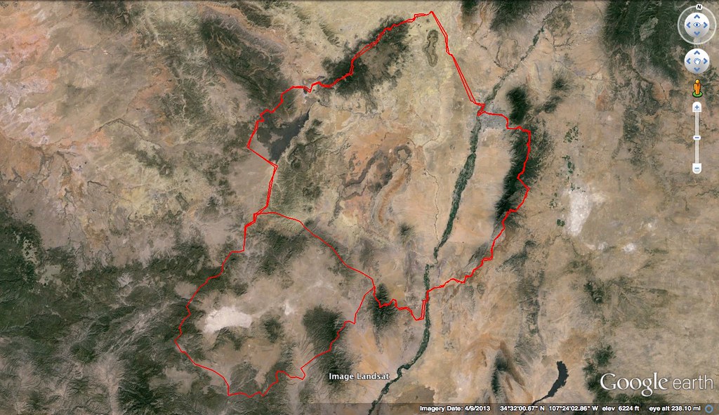 Riding Conditions: Riding Conditions: The majority of this riding is on old jeep or logging roads. Most of these are not actively maintained by the Forest Service (though a few are) and so it is not a gravel grind. Some are being absorbed back into the forest, others are used enough by hunters and 4X4 people to keep cleared (they will remove felled trees and the like) and still others are mainly used by wildlife. There are some sections of singletrack in the areas I have explored and I have found a few animal trails that cut through little valleys that are really fun to ride. It’s a mixed bag with a little bit of everything. The burliest sections will be Mount Taylor (at over 11,000 feet), the Gila, San Mateo Mountains and, if doing the shorter route, the Sawtooth Mountains and surrounding forestland north of SR 60. Other challenges include some very open, exposed and monotonous grasslands that, if windy (its New Mexico and we usually have wind…), can be a real grind. Food and Water: Water sources consist of springs and cattle tanks, some of which are not reliable. Except for down in the Gila, I don’t think there is an active stream on the entire route (except for the Rio Grande). I have gathered guides and other info from the Grand Enchantment Trail and the Continental Divide Trail both of which have detailed information about water sources. It does pass through a number of towns to refuel on food and water, recharge a phone, etc.
|
|
|
« Last Edit: April 15, 2015, 09:05:25 PM by wahday »
|
Logged
|
|
|
|
|
Topic Name: Two big New Mexico Bikepacking Routes - wanna help me chart and ride them?
|
Reply #5 on: April 20, 2015, 09:09:01 AM
|
cbriggs
Posts: 2
|
|
« Reply #5 on: April 20, 2015, 09:09:01 AM » |
|
My planned route was more of a northern mountain loop. A mix of mainly roads, little bit of pavement and any small sections of singletrack that exist in Northern New Mexico, incorporating parts of the GDR, CDT, and also Scott and Ezter's route. Tried to hit as many of many NM favorites as possible such as hot springs, the Valle Vidal, South Boundary and Taos. Initially thinking of a solo trip so I was going to end in Taos, get free public transportation to Santa Fe, then the Rail Runner back to Abq. I'm sure the route could be extended all the way back to Albuquerque though I seem to have a hard time finding a quality bypass of the Pecos Wilderness(possibly the East side then going over to the Elk Mountain area of the Pecos). Looks like our routes could easily be combined for a Very Large New Mexico Loop! I love beer by the way, so let me know if you're in town for info sharing or trip planning. Attached a screen shot of what I had come up with previously.
|
|
|
|
Logged
|
|
|
|
|
Topic Name: Two big New Mexico Bikepacking Routes - wanna help me chart and ride them?
|
Reply #6 on: April 20, 2015, 10:48:51 AM
|
wahday
Location: New Mexico
Posts: 251
|
|
« Reply #6 on: April 20, 2015, 10:48:51 AM » |
|
Thanks for posting that. A little while back I had also contemplated a border-to-border ride which then got whittled down to going from Cimarron to Tierra Amarilla. Some of that route lines up with what you have here. South Boundary Trail was part of it, for example. Having ridden that trail, that initial climb from Angel Fire is a real bear. I can’t imagine doing it loaded with gear. But worth the HAB to make that ride into Taos!
And you are right that these two ideas could be combined by connecting from Cebezon to the Valles Caldera. Monster Loop NM! Getting back from Taos or even Santa Fe by bike appears challenging on dirt. Between the Pecos Wilderness area and Tribal land the options are few. I am ok with the Rail Runner and other public transit. I mainly like the idea of just leaving from home and not parking a car somewhere. But if you could complete the loop, then I think this route becomes viable as something that is promoted and potentially developed for recreational riding (again, like many of the trails other states have – AZT, CT, White Rim, Kokopelli, etc.)
I am up for beer but am slammed with work at the moment so I will be in touch when the dust settles and propose some dates. Will PM you.
|
|
|
|
|
Logged
|
|
|
|
|
Topic Name: Two big New Mexico Bikepacking Routes - wanna help me chart and ride them?
|
Reply #7 on: April 20, 2015, 11:13:36 AM
|
ScottM
bikepacking.net admin
Location: Wherever the GeoPro is parked.
Posts: 2863

|
|
« Reply #7 on: April 20, 2015, 11:13:36 AM » |
|
Love seeing this talk. I think a long-lasting and well researched bikepacking route in NM is long overdue, and I love the idea of a GET/CDT loop. Let me know how I can help. I think most of my beta is out in blog and GPX form already, though. Here's a bit of new info, from a recent bikepack by Pie Town: https://zenondirt.wordpress.com/2015/04/16/pie-town-bikepack-the-perfect-fusion-of-the-cdt-and-gdmbr/Just some more good singletrack to consider, if going all the way down to the Gila. |
|
|
|
|
Logged
|
|
|
|
|
Topic Name: Two big New Mexico Bikepacking Routes - wanna help me chart and ride them?
|
Reply #8 on: April 20, 2015, 01:35:51 PM
|
wahday
Location: New Mexico
Posts: 251
|
|
« Reply #8 on: April 20, 2015, 01:35:51 PM » |
|
Awesome Scott - thanks for chiming in!
|
|
|
|
|
Logged
|
|
|
|
|
Topic Name: Two big New Mexico Bikepacking Routes - wanna help me chart and ride them?
|
Reply #9 on: April 20, 2015, 02:11:17 PM
|
ScottM
bikepacking.net admin
Location: Wherever the GeoPro is parked.
Posts: 2863
|
|
« Reply #9 on: April 20, 2015, 02:11:17 PM » |
|
You might hit up Blisterfree for ideas on the northern connection. He has been scheming in that direction, too. He sees the bigger picture of a massive southwest long distance trail network including the AZT, CDT, GET and Hayduke trails.
|
|
|
|
|
Logged
|
|
|
|
|
Topic Name: Two big New Mexico Bikepacking Routes - wanna help me chart and ride them?
|
Reply #10 on: June 18, 2015, 09:55:35 AM
|
wahday
Location: New Mexico
Posts: 251
|
|
« Reply #10 on: June 18, 2015, 09:55:35 AM » |
|
Just a quick update on my little project here to bump this thread:
• I have mapped the section from Pie Town to Magdalena and made note of what appear to be actively maintained cattle tanks as water sources (talking about actual metal storage tanks here and not what the maps call “tanks” which are engineered depressions in the ground that collect runoff. Those are notoriously unreliable unless it has just rained). I also noted any settlements or homes/properties that might be sources as well.
• I have mapped the route from Albuquerque to Cabezon.
These two sections represent areas for which I do not have beta. The other two sections of the route are part of the Continental Divide Trail and the Grand Enchantment Trail and the data on this comes from Scott Morris who has actually ridden both segments. The routes create a large figure 8 which allows for three configurations (more if you are willing to ride some sections twice). The northern loop (beginning and ending in Albuquerque) is ~550 miles, the southern loop (starting and ending in Socorro) is ~350 miles (but gnarlier terrain) and the large loop (beginning and ending in Albuquerque) is ~750 miles.
The objective this summer is to ride at least from the Zunis to Albuquerque via Mt. Taylor and Cabezon peak. If time permits, I would also like to ride from the Zunis to Socorro or Albuquerque via Pie Town and Magdalena to verify that route as well.
Does time permit? That is the big question. The good news is that I am quitting my job so, yes, there may be time on the horizon (but not endless time – I do need to get another job). The challenge is that it is two to three months away and takes us into shorter days and hunting season. Still can be done, but does present some additional challenges.
Outside of available time, water is the biggest variable. I have been using the trail guides for both the CDT and GET to identify water sources. For the unridden sections I have been looking at USGS maps and comparing to current aerials to identify the cattle tanks. In Google maps you can get imagery from a variety of years so if I can see water in the tanks going back several years, I consider it a “reliable” sources and create a waypoint. Even with all of that, it still looks like there may be one or two 24 to 36 hour sections with no water access. I am thinking that I will need up to 8 liters of water on those stretches. Water is heavy, but dehydration is worse so I am erring on the side of caution. With this weight, I am also anticipating an average daily mileage of 30 to 35 miles. There are some vast open stretches that may go faster, but I am also trying to account for wind and unexpected developments (like getting a little lost). I may revise that down just to be safe and then be pleased when things move along faster than expected.
So I am looking at September or October to make one or both of these journeys (Zunis to Albuquerque = 3 days, Zunis to Albuquerque via Pie Town/Magdalena = 8 days). PM me if anyone here has interest. I will reach out to those who expressed interest so far when I have firmer dates.
I am really excited about the possibility of establishing this as a designated biking/hiking route. And as has been noted, there are opportunities to link it to routes further north as well. I really think our state has been missing out on potential recreational tourism potential by not having something like a Colorado Trail, Arizona Trail, Idaho Boundary Trail, Idaho Hot Springs Trail, Pacific Northwest Trail, etc.
Thanks for suffering my ruminations.
|
|
|
|
|
Logged
|
|
|
|
|
Topic Name: Two big New Mexico Bikepacking Routes - wanna help me chart and ride them?
|
Reply #11 on: July 01, 2015, 06:58:11 PM
|
dadana
Location: albuquerque
Posts: 37
|
|
« Reply #11 on: July 01, 2015, 06:58:11 PM » |
|
Wahday, mind sharing the route from the Compressor Station on Pipeline Rd to Rio Rancho?
|
|
|
|
|
Logged
|
|
|
|
|
Topic Name: Two big New Mexico Bikepacking Routes - wanna help me chart and ride them?
|
Reply #12 on: July 02, 2015, 10:45:15 AM
|
wahday
Location: New Mexico
Posts: 251
|
|
« Reply #12 on: July 02, 2015, 10:45:15 AM » |
|
On vacation now but will post the route when I return. I am not sure where the compressor station is (i am guessing it is to the southeast of Cabezon, between it and White Mesa?) but I have the route from Albuquerque to Cabezon where it connects to the CDT.
Sent from my iPhone using Tapatalk
Ok, back now. Attached is the file as a gpx.
|
|
|
« Last Edit: July 06, 2015, 01:34:46 PM by wahday »
|
Logged
|
|
|
|
|
Topic Name: Two big New Mexico Bikepacking Routes - wanna help me chart and ride them?
|
Reply #13 on: September 01, 2015, 02:57:21 PM
|
geekonabike
Location: RedNeck Alps (White Mtns, AZ)
Posts: 207
|
|
« Reply #13 on: September 01, 2015, 02:57:21 PM » |
|
I'm in Vernon, AZ about 100mi west of Pie Town. I had been planing on a Pie Town to Silver City ride, but I could alter that if you need anything on south or west sides GPSs or Checked out
|
|
|
|
|
Logged
|
What don't Kill You, only makes You Smell Stronger
|
|
|
|
Topic Name: Two big New Mexico Bikepacking Routes - wanna help me chart and ride them?
|
Reply #14 on: September 05, 2015, 08:48:19 AM
|
wahday
Location: New Mexico
Posts: 251
|
|
« Reply #14 on: September 05, 2015, 08:48:19 AM » |
|
I'm in Vernon, AZ about 100mi west of Pie Town. I had been planing on a Pie Town to Silver City ride, but I could alter that if you need anything on south or west sides GPSs or Checked out
Hey geekonabike, Thanks for reaching out! I would be thrilled if you were interested in doing some exploration. Attached is the updated route I have created that connects Pie Town and Magdalena if that interests you at all. I realize this is heading east from you and may not work, but thought I would throw it out there. This is unridden territory that I have no information about, thus the need. I created the route tracing roads on aerials and USGS maps. The .kml file you can open in Google Earth and the .gpx you will need some kind of GPS software (not sure how much you use these tools). I am hoping to do this section myself and would be interested in when you are planning to go out. There are just a couple of sections that may require some short bushwhacking (both through canyons) but otherwise it is all along old logging roads and forest roads all confirmed through aerial imagery. You go through the Sawtooth Mountains, Datils, etc. It is 83 miles and I would take 3 days to do it. I'm not focused on speed personally and with this I wanted to take the time to identify good water sources and other notable discoveries. I also want to accommodate potential confusion and rerouting. Take a look and let me know what you think. If you want to chat more, PM me and we can talk details. In Earth, I have created waypoints for a number of water tanks that appear to be reliable water sources. I can share that information as well. Otherwise, I am curious what route you were intending to take to Silver City. That also sounds like a great trip! Let me know if you can view this info and want to talk! |
|
|
« Last Edit: September 05, 2015, 09:28:33 PM by wahday »
|
Logged
|
|
|
|
|
Topic Name: Two big New Mexico Bikepacking Routes - wanna help me chart and ride them?
|
Reply #15 on: September 05, 2015, 01:34:43 PM
|
geekonabike
Location: RedNeck Alps (White Mtns, AZ)
Posts: 207
|
|
« Reply #15 on: September 05, 2015, 01:34:43 PM » |
|
Just the GPS is plenty for me. I'm a long time TopoFusion user. I'd planed on hitting the CDT or GDR route. this one will do & maybe I return by another route. Years ago I lived on the Rama Navajo Rez. I'd like to look at the CDT over that too. Any waypoints I need to keep other than water & food sources?
|
|
|
|
|
Logged
|
What don't Kill You, only makes You Smell Stronger
|
|
|
|
Topic Name: Two big New Mexico Bikepacking Routes - wanna help me chart and ride them?
|
Reply #16 on: September 05, 2015, 07:00:24 PM
|
wahday
Location: New Mexico
Posts: 251
|
|
« Reply #16 on: September 05, 2015, 07:00:24 PM » |
|
Excellent! Scott has the full CDT file available as you probably know. It was looking at that and the GET that made me think the two could be connected in ways to create some loops from Albuquerque.
As far as things to be aware of, there are a few private residences that the route goes by, including one that is more of a little settlement, This entire area includes a good amount of private land within the forest service boundaries. My understanding is that forest roads crossing through private land must allow through access to the general public. But it is good to be prepared for having to explain yourself to a stranger out in the middle of nowhere. I have these marked as well because they can also be potential water sources. Since you live close by you are probably aware, but hunting season starts this weekend and this is prime elk country. I always wear blaze orange in the fall just in case.
Really, water would be my primary concern. I have struggled with how much I think I will need carry to bridge the largest gaps in sources. I have settled on somewhere between 8 and 10 liters for a 24 hour period. since you live in the area I am curious what your experience is.
We own land between the Bandera Ice Caves and El Morro National Monument. I am somewhat familiar with the Pine Hill and Candy Kitchen area which I am guessing is around where you lived? A very interesting area... I have used our place as a jumping off point for riding in the Zunis, Chain of Craters, El Malpais, etc. I rode some of the CDT in the Chain of Craters but later learned that bikes are not allowed along that portion because it is a Wilderness Study Area (tugs nervously at collar). The CDT down into the Gila looks very exciting. Some rugged country for sure.
I have a small correction to make on the route that I just noticed. I will replace the one above and PM you so you can get the corrected version.
|
|
|
|
|
Logged
|
|
|
|
|
Topic Name: Two big New Mexico Bikepacking Routes - wanna help me chart and ride them?
|
Reply #17 on: September 05, 2015, 07:16:57 PM
|
geekonabike
Location: RedNeck Alps (White Mtns, AZ)
Posts: 207
|
|
« Reply #17 on: September 05, 2015, 07:16:57 PM » |
|
Sounds good I been looking at the track in topofusion. It hints at a lot of tanks, but I'll take a gravity filter, steri pen & tablets. I y have alive off grid & outback before, so I don't usually don't have issues with rural people.
I have some trail work to finish up here for our local race (tour of the white mtns) but I may well have that finished early next week.
|
|
|
|
|
Logged
|
What don't Kill You, only makes You Smell Stronger
|
|
|
|
Topic Name: Two big New Mexico Bikepacking Routes - wanna help me chart and ride them?
|
Reply #18 on: October 07, 2015, 01:37:02 PM
|
Yogi the Barry
Location: Land of Detachment
Posts: 482
|
|
« Reply #18 on: October 07, 2015, 01:37:02 PM » |
|
Wahday [name?], How ironic that I just decided to bail on the Coco 250 and was perusing the bikepacking forums, out of remorse, and found this thread. Sorry for not having noticed it earlier. Especially since I live in Albuquerque and have ridden [and will ride] NMES/AZT/CTR type events. I plan on campaigning AZT/CTR next year and this would fit right into my training next spring... and perhaps even this Fall/Winter. Until I get a chance to peruse the entire thread, I'll comment that I have ridden from Albuquerque to Cabezon two times, during what I call the Washboard 100. a.k.a. the San Ysidro Dirty 100 NMES race. In the past this course used the pipeline road which essentially goes form ABQ to Bloomfield. And almost every foot of it is covered in E150 washboards. Distilled, you would never want to intentionally ride this pipeline road. However, would be really cool if your route could include White Mesa... BTW, I have an eTrex 30 and full version of TopoFusion. Send me a PM for rides. As a matter of fact, doing South Boundary this upcoming Oct. 10th Saturday. More later, Barry Ritchey I have been working on routes for two large bikepacking loops that begin and end in Albuquerque (one being a shortened version of the other). They are roughly 550 and 750 miles each, maybe a bit more. These rides build on the efforts of Scott Morris (and others) to ride the Grand Enchantment Trail (GET) ....snip...
I will post a few images of what I have mapped to date so people can better see what I am referring to. In the meantime, what say you? Does this interest anyone else out there? Want to get together and share some beta (and beer?)
|
|
|
|
« Last Edit: October 07, 2015, 01:40:51 PM by Yogi the Barry »
|
Logged
|
|
|
|
|
Topic Name: Two big New Mexico Bikepacking Routes - wanna help me chart and ride them?
|
Reply #19 on: October 09, 2015, 07:04:37 AM
|
bakerjw
Posts: 464
|
|
« Reply #19 on: October 09, 2015, 07:04:37 AM » |
|
You guys are lucky to be out there where there are so many routes. We have mountains out here but so much is off limits due to private ownership or places like the AT.
|
|
|
|
|
Logged
|
|
|
|
|
|


