Pages: [1]
Reply Reply New Topic New Poll
  Topic Name: Arizona Trail GPS network out on: November 17, 2008, 06:43:24 PM
ScottM
bikepacking.net admin


Location: Wherever the GeoPro is parked.
Posts: 2863


View Profile WWW
« on: November 17, 2008, 06:43:24 PM »

I sat down today and combined a massive amount of AZT GPS data using TopoFusion's network algorithm.  I'm calling the result the AZT Network.

Since the AZT is a work-in-progress and there are a number of options available to Arizona Trail cyclists, this GPX file tries to sort out the differences.


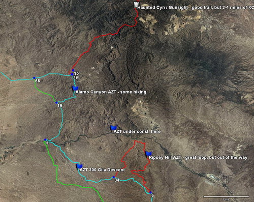
Each track is colored according to the following table:
CyanThe current recommended route
GreenEasier / road alternates, usually as described in Andrea's book
RedHike-a-bike or otherwise adventurous segments for true AZT junkies

Note: if you don't see the track colors, upgrade to the latest version of TopoFusion.  Older versions didn't display per-track coloring.  If your GPS software doesn't display the colors, get TopoFusion!


You can get the AZT network file over on bikepacking.net's Arizona Trail Page under the routes area.

I'll be updating it this year as more GPS data trickles in, but it's got the best of what's out there right now.  Comments, suggestions or problems can be posted here or in the comments section of bp.net's AZT page.  This is v1 of the data.
Logged

Author of TopoFusion GPS software.  Co-founder of trackleaders.com - SPOT event tracking.

  Topic Name: Arizona Trail GPS network out Reply #1 on: November 24, 2008, 08:22:11 AM
SandLizrd


Posts: 21


View Profile
« Reply #1 on: November 24, 2008, 08:22:11 AM »

Thanks Scott - I promise to make good use of it!


Somehow I had a bad download at one point - the file seemed way too small or something, because when I loaded the 1.83 meg version it worked much better
« Last Edit: November 24, 2008, 08:40:13 AM by SandLizrd » Logged

  Topic Name: Arizona Trail GPS network out Reply #2 on: November 24, 2008, 08:29:46 AM
ScottM
bikepacking.net admin


Location: Wherever the GeoPro is parked.
Posts: 2863


View Profile WWW
« Reply #2 on: November 24, 2008, 08:29:46 AM »

Looks like you figured it out...
Logged

Author of TopoFusion GPS software.  Co-founder of trackleaders.com - SPOT event tracking.

  Topic Name: Arizona Trail GPS network out Reply #3 on: February 02, 2009, 09:27:34 AM
YuriB


Posts: 63


View Profile WWW
« Reply #3 on: February 02, 2009, 09:27:34 AM »

This is fantastic and your timing is perfect!
Logged

  Topic Name: Arizona Trail GPS network out Reply #4 on: November 11, 2009, 08:55:17 PM
ScottM
bikepacking.net admin


Location: Wherever the GeoPro is parked.
Posts: 2863


View Profile WWW
« Reply #4 on: November 11, 2009, 08:55:17 PM »

Version 2 of the AZT network is now up (on the AZT route page listed above), including many new singletrack tasties.  Rosemont -> Lakes Road (riding Highway 83 is no longer required!), Gila River stuff (Kelvin), Mormon Lake area, NW side of the peaks...

The AZT is rocking right along... not too long until the whole dang thing is done.

Big thanks to Tim M for contributing a bunch of GPX files for some of the new stuff.
Logged

Author of TopoFusion GPS software.  Co-founder of trackleaders.com - SPOT event tracking.
  Pages: [1]
Reply New Topic New Poll
Jump to: