Routes » Maah Daah Hey Trail
Overview
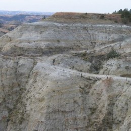
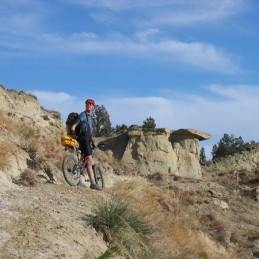
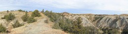
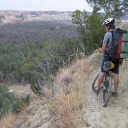
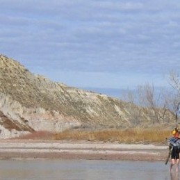
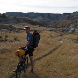
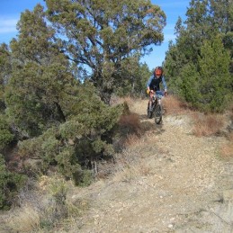
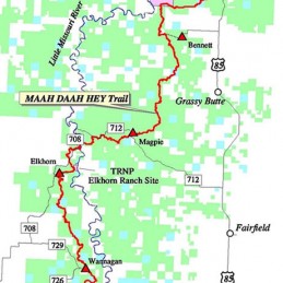
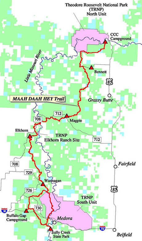
Located in western North Dakota the Maah Daah Hey connects the two units of Theodore Roosevelt National Park. The landscape consists of shortgrass prairie and badlands. The Maah Daah Hey is one of the best mtb trails in the US. It boasts over a hundred miles of pure backcountry riding. Except for a 10 mi gravel road detour around the Northern Unit of Theodore Roosevelt NP it is all off road riding, mainly on singletrack. The scenery is amazing and the trail is rideable for it’s entire length. It is a great destination for bikepacking because it is also a horseback riding trail so most of the climbs are gently graded and have wide switchbacks. Most of the National Park is wilderness so if you’re on a bike you will detour around the north unit on gravel roads and around the south unit on the excellent Buffalo Gap singletrack. The loop road in the south unit is a fantastic road bike ride!
Trail development is currently underway to extend the trail another 40+ miles south of Medora, this is sometimes known as the Maah Daah Hey Trail II, or the Deuce.
Info
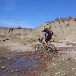
The trail is at an elevation between 2000 and 2700 feet, the longest climbs are about 500 feet and only a few of those, most are much smaller. This means the trail is quite doable even with a load and with moderate fitness. The surface is mostly hard packed clay. Because of the erosion the trail is sunk in to the ground creating mini berms at just about every turn. Unfortunately this also means some serious ruts and hoof pockmarks from cattle walking across the wet clay. Which leads to the warning: you can not ride this trail when wet! The Bentonite clay sticks like glue to your bike and shoes. So check the forecast and stay home if it’s going to rain! The detour around the south unit is technically not the Maah Daah Hey but the Buffalo Gap trail, it continues south of I-90, in fact this is one of the best sections from a pure riding standpoint, rollers and berms like a giant BMX track.
There are campgrounds located near the trail at roughly 20 mi intervals. There is a short spur trail to the campsite from the trail. Be sure to factor in the extra mileage of the out and back to the camp in your total miles for the day. All camps have drinking water but it is turned off in winter, call the Forest Service to check the dates. Other than the camps there are a few stock tanks of questionable quality and some small creeks. The running water tends to be extremely silty due to the clay soil that the Badlands consist of. Filtering the water will be a major challenge for any water filter, so most people just stock up at the campgrounds. The campgrounds can be reached by car, as can many other trail crossings, so it is possible to cache water or food ahead of time.
It is a great plains landscape with extreme heat in summer and cold in winter. North Dakota is also one of the windiest parts of the US, and there is very little tree cover so be prepared for some epic battles with the wind.
For a small fee the forest service will mail you an excellent map of the trail, which has an elevation profile on it. Be sure to also bring a highway map/ coarse scale topo map of the area. If you need to bail, the highway that parallels the trail is just of the trail map in most spots, so being able to find a route out of the back country onto the highway requires an additional map.
There are several ranchers in the area who act as hunting guides/outfitters and can be hired to shuttle you and your bikes to the other end of the trail, Dakota Cyclery in Medora does as well. With some talking and explanation, we managed to get a taxi in Wiliston to drop us off on the trail. Remember that the Rocky Mountain Time Zone line runs right through this area, so be sure to check what time someone is on when making appointments.
Williston, ND is the closest airport and Amtrak station, it is about 65 miles north of the northen terminus of the trail. It is not very advisable to bike on the roads outside of Williston, they are in the midst of a major oil boom and the roads are packed to overflowing with double trailer tanker trucks and angry locals fed up with traffic.
Hazards
If you read any trip reports two warning stand out: bring more water and watch out for cactus thorns in your tubes. The water can be a challenge. The thorns are easily dealt with by using tubeless tires with Stan’s. I used an ultralight 127tpi casing tire and had no flats, but plenty of thorns in my shoes and shorts. Or you could use Slimed tubes. There are few sharp rocks, so you can use a lighter casing tire without to much risk. It helps if your tires clear mud reasonably well, because of puddles and stream crossings, the same goes for your pedals. The Bentonite clay is extremely sticky. It filled up my Candy pedals completely so I had to poke out the mud with a twig, a few times. The other hazard is the crossing of the Little Missouri river. If it is running high you might have to start or end at the river. Even in nice weather the water is fast and very cold.
GPS Data
This page has some GPS waypoints for the trail: http://www.stoneylonesomephotos.com/Maah-Daah-Hey/area3.htm
We are looking for a complete GPS track of the MDH.
There is a McKenzie map at about 1:116,000 scale available from the forest service and a National Geographic map at 1:40,00 scale. Note that one of the maps claims there is no water at one of the campsites. This is incorrect. There is water at each one. (As long as the USFS hasn’t turned it off).
Trip Reports
Dave Holland’s One day run
Ct Rd 50 to Buffalo gap in fall
Links
National Park service page on MDH
Dakota Cyclery bikeshop/shuttle in Medora
Forest service Medora ranger District phone: 701-225-5151
Updated October 2012
Any beta on getting around that little annoying section of the north unit of TRNP?
No, when we went 2 years ago we saw some hints on the web that some rancher might let you cross his land for a small fee, but we never could pin it down. When we were out there we rode/hike-a-biked along the fence until we came to a dead end, stuck between a wall and facing a drop off. I suggest just getting of the trail sooner and riding the gravel roads.
For those of you in the Chicago area, Wisconsin or Minnesota: consider Amtrak trains to get out there.
You can leave after work in the evening, sleep on the train and get to Williston by 11:30 am.
Ride a few days, then board at 7:00pm. Sleep on the train, and be back in MN/WI in the morning in time to work a pretty good day.
If you haven’t been on Amtrak out west:
Coach seats on the train are similar in size to business class on an airplane, and include thigh and foot rests as well as drinking water fountains in the cars.
If you upgrade to a sleeper you get meals included. There is usually a bar car serving drinks as well.
RE Amtrak:
Be aware that you can only take your bike if you board at a station with checked baggage service. Williston, ND does have baggage service.
We left our bikeboxes and duffelbags with street clothes in the station, there might be a fee for that, but we got lucky.
Amtrak will NOT take the bike wedge shaped Aircaddy box. however they have their own boxes which they give you for free if they are used, else they are $20. Bike fee is $15 per bike and max weight for the total is 50 lbs. Their boxes are huge. All I had to do was take off pedals and front wheel, and loosen my stem faceplate. I have a huge bike(I am 6’5″ and sit upright). I have seen these boxes used in airports as well. Bikebox handling was clumsy leading to a dropped box, so some padding(we used outr bags) might be good.
We paid $165 for Basin Cab co to drive us out to the middle of the trail from Williston($2/mi), they have minivans and were very helpful. It did take some explaining where we wanted to go, and that we were not wanting to be picked up there later that day!
We had the owner of Buffalo Gap Guest Ranch take us back to Williston in his truck, for about $195.
Planning to ride the trail next (mid) June. Any speculation on the chance of rain?
Is there any tire out there that can withstand Bentonite Clay?
Can you use dirt roads to get from campsite to campsite (if it rains)?
All the campsites are on dirt roads. Unfortunately, most of those are clay too. I would think they would hold up a bit longer than the trail, but once they are soaked they would be horrible to. You might be able to find narrow bands with sufficient gravel to keep riding, or ride in the grass.
Tire choice for a true rain event wouldn’t really matter, it’s the 4″ of mud all over your wheel and crank that would be the problem. A slightly spikier and more spaced tread will help with traction after riding through a creek though.
Just joined this forum and read this route description stating you are looking for a .gpx file of the route. I raced the Maah Daah Hey 100 in 2014 and have a .gpx file of the route from the CCC campground to Medora. My file info says it’s about 104 miles and it includes the most recent track – they had to reroute a few sections because of some new oil wells. Let me know how I can upload it or feel free to get in touch if you want it. Cheers! – Matt
Hi Matt,
I am planning on riding in August and was looking for a .gpx file of exactly the route that you have. Would you mind letting me steal your work?
Hey Sam,
You can grab mine from my Strava page. I also raced the MDH100 in 2016. Here’s the ride report with a link to Strava at the bottom (I have a link on the right sidebar to a handy gpx converter for Strava):
http://schillingsworth.blogspot.com/2016/08/maah-daah-hey-100.html