 Topic Name: Tour Divide 2012 "official" GPX files are Available Topic Name: Tour Divide 2012 "official" GPX files are Available
|
on: May 17, 2012, 09:07:40 AM
|
woody
Location: Southern Utah
Posts: 286

|
 |
« on: May 17, 2012, 09:07:40 AM » |
|
Hey All, I just noticed that the Tour Divide 2012 "official" GPX files are available. "Updated 5/15/12 Tour Divide files use three alternate routes in New Mexico, as allowed by the event, and has been updated for 2012 to include a portion of the Gold Dust trail in Colorado." http://www.topofusion.com/divide/gps.phpWoody |
|
|
|
|
 Logged
|
|
|
|
|
Topic Name: Tour Divide 2012 "official" GPX files are Available
|
Reply #1 on: May 17, 2012, 09:19:54 AM
|
ScottM
bikepacking.net admin
Location: Wherever the GeoPro is parked.
Posts: 2863

|
|
« Reply #1 on: May 17, 2012, 09:19:54 AM » |
|
Thanks, I was just about to post a note about this.
|
|
|
|
|
Logged
|
|
|
|
|
Topic Name: Tour Divide 2012 "official" GPX files are Available
|
Reply #2 on: May 17, 2012, 09:20:56 AM
|
woody
Location: Southern Utah
Posts: 286
|
|
« Reply #2 on: May 17, 2012, 09:20:56 AM » |
|
No Thank you  Woody |
|
|
|
|
Logged
|
|
|
|
|
Topic Name: Tour Divide 2012 "official" GPX files are Available
|
Reply #3 on: May 17, 2012, 09:36:30 AM
|
Georg66
Location: Heidelberg, Germany
Posts: 128
|
|
« Reply #3 on: May 17, 2012, 09:36:30 AM » |
|
Hey All, I just noticed that the Tour Divide 2012 "official" GPX files are available. "Updated 5/15/12 Tour Divide files use three alternate routes in New Mexico, as allowed by the event, and has been updated for 2012 to include a portion of the Gold Dust trail in Colorado." http://www.topofusion.com/divide/gps.phpWoody Is gold dust trail the only difference to the 2011 version? Thanks. Georg |
|
|
|
|
Logged
|
|
|
|
|
Topic Name: Tour Divide 2012 "official" GPX files are Available
|
Reply #4 on: May 17, 2012, 09:58:04 AM
|
ScottM
bikepacking.net admin
Location: Wherever the GeoPro is parked.
Posts: 2863
|
|
« Reply #4 on: May 17, 2012, 09:58:04 AM » |
|
Yes. Well, the only difference to the (unused) full 2011 version. There were a bunch of snow detours last year.
It's only half of the Gold Dust trail, too.
|
|
|
|
|
Logged
|
|
|
|
|
Topic Name: Tour Divide 2012 "official" GPX files are Available
|
Reply #5 on: May 17, 2012, 11:44:48 AM
|
elobeck
Posts: 229
|
|
« Reply #5 on: May 17, 2012, 11:44:48 AM » |
|
Thank you TD admin for posting track. Question: Does this track satisfy TD rule #3:
"Challengers must always ride 100% of the 'main' ACA Great Divide Route as defined by the most current edition of the ACA maps. Previous map editions may not be used unless updated with the most current ACA Addenda."
In other words, with the exception of Golddust", am I assuming correctly that the GPX track is a SUPPLEMENTARY AID and the ACA route with current updates reigns supreme ? OR is the track the "official" route even if discrepancies exist between the GPX route and the ACA route (not sure if there are any yet, need to look at them again).
Erik
|
|
|
|
|
Logged
|
|
|
|
|
Topic Name: Tour Divide 2012 "official" GPX files are Available
|
Reply #6 on: May 17, 2012, 12:46:29 PM
|
Georg66
Location: Heidelberg, Germany
Posts: 128
|
|
« Reply #6 on: May 17, 2012, 12:46:29 PM » |
|
In order to get a first impression about Gold Dust Trail, I put a picture of the whole GDtrail (margenta route,), and green the Tour Divide track as provided here: http://www.topofusion.com/divide/gps.phpYou will see, that - as mentioned by ScottM - the green track branches off the GDT at half of its length, to Boreas Pass road. (without guarantee) 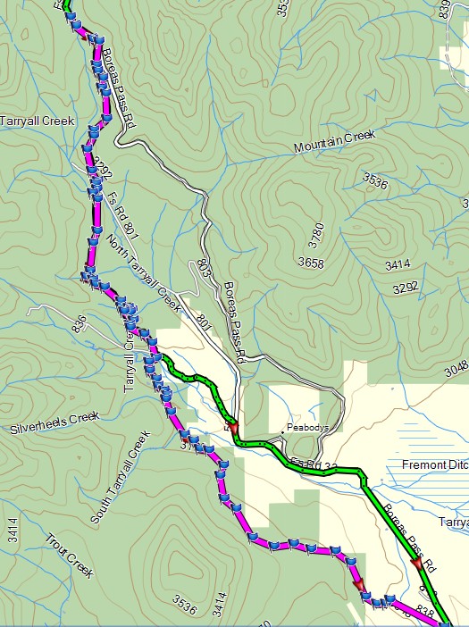 |
|
|
|
|
Logged
|
|
|
|
|
Topic Name: Tour Divide 2012 "official" GPX files are Available
|
Reply #7 on: May 17, 2012, 01:07:13 PM
|
woody
Location: Southern Utah
Posts: 286
|
|
« Reply #7 on: May 17, 2012, 01:07:13 PM » |
|
Yes. Well, the only difference to the (unused) full 2011 version. There were a bunch of snow detours last year.
It's only half of the Gold Dust trail, too.
So I'm getting confused - we only do the top half of Gold Dust, correct? Cue#7 is where a cabin with a blue tin roof and then we take that road (Co Rd 50) into Como, right? The cues I found are for the whole trail, but we do NOT go over the (cue#9) timber bridges. That's where it turns into a hike-a-bike "rock garden" section so that's a good thing with a loaded rig. It's pretty easy to see in Google Earth. Woody |
|
|
|
« Last Edit: May 17, 2012, 01:13:54 PM by woody »
|
Logged
|
|
|
|
|
Topic Name: Tour Divide 2012 "official" GPX files are Available
|
Reply #8 on: May 17, 2012, 01:14:06 PM
|
pgadola
Posts: 24
|
|
« Reply #8 on: May 17, 2012, 01:14:06 PM » |
|
I hope that we can get an 'official' cue sheet out on the Gold Dust Trail to eliminate any chance of someone missing a 'required' section.
|
|
|
|
|
Logged
|
|
|
|
|
Topic Name: Tour Divide 2012 "official" GPX files are Available
|
Reply #9 on: May 17, 2012, 02:38:52 PM
|
jryter
Location: Gunnison, CO
Posts: 133
|
|
« Reply #9 on: May 17, 2012, 02:38:52 PM » |
|
Thanks for the work Scott, et al.
Now just pedal my bike for me.....
Jarral
|
|
|
|
|
Logged
|
|
|
|
|
Topic Name: Tour Divide 2012 "official" GPX files are Available
|
Reply #10 on: May 17, 2012, 03:38:22 PM
|
groundedkiwi
Posts: 57
|
|
« Reply #10 on: May 17, 2012, 03:38:22 PM » |
|
Thanks Scott,
Hey quick question if you've time.....how much detail is lost with the shrunken to 10k track? I'm wondering if its worth the effort to make multiple tracks sub 10k from the master track, or use the smaller version.
I have en eTrex30, and just a little over paranoid about getting lost and blowing time.
Not too worried though if you seem to think there'll be sufficient detail.
I only just downloaded it a few minutes ago, so haven't had time to go over it, turn by turn yet.
Thanks for your work on our behalf,
Grounded
|
|
|
|
|
Logged
|
|
|
|
|
Topic Name: Tour Divide 2012 "official" GPX files are Available
|
Reply #11 on: May 17, 2012, 07:22:35 PM
|
rooster14
Location: Oxford, Oh
Posts: 48
|
|
« Reply #11 on: May 17, 2012, 07:22:35 PM » |
|
haha, i was not nervous about the route until reading through this. yikes.
|
|
|
|
|
Logged
|
ships are safe in the harbor but that is not what ships are for.
|
|
|
|
Topic Name: Tour Divide 2012 "official" GPX files are Available
|
Reply #12 on: May 18, 2012, 01:47:21 PM
|
ScottM
bikepacking.net admin
Location: Wherever the GeoPro is parked.
Posts: 2863
|
|
« Reply #12 on: May 18, 2012, 01:47:21 PM » |
|
In other words, with the exception of Golddust", am I assuming correctly that the GPX track is a SUPPLEMENTARY AID and the ACA route with current updates reigns supreme ? OR is the track the "official" route even if discrepancies exist between the GPX route and the ACA route (not sure if there are any yet, need to look at them again).
I talked to Matthew about this, and while we have done our best to make sure the track is 100% in alignment with the ACA maps, both are accepted as the official route in case of any discrepancy. So you are good to go following either one exclusively. We did find one small (one block) difference in the v1 track posted in the town of Como, CO. I'll have a v2 track up as soon as we're done triple checking it. |
|
|
|
|
Logged
|
|
|
|
|
Topic Name: Tour Divide 2012 "official" GPX files are Available
|
Reply #13 on: May 18, 2012, 01:48:50 PM
|
ScottM
bikepacking.net admin
Location: Wherever the GeoPro is parked.
Posts: 2863
|
|
« Reply #13 on: May 18, 2012, 01:48:50 PM » |
|
I hope that we can get an 'official' cue sheet out on the Gold Dust Trail to eliminate any chance of someone missing a 'required' section.
Pretty sure ML will have an updated cue for GDust trail. Should be an easy change since it's a big forest road that you cut off on. |
|
|
|
|
Logged
|
|
|
|
|
Topic Name: Tour Divide 2012 "official" GPX files are Available
|
Reply #14 on: May 18, 2012, 01:51:35 PM
|
ScottM
bikepacking.net admin
Location: Wherever the GeoPro is parked.
Posts: 2863
|
|
« Reply #14 on: May 18, 2012, 01:51:35 PM » |
|
Thanks Scott,
Hey quick question if you've time.....how much detail is lost with the shrunken to 10k track? I'm wondering if its worth the effort to make multiple tracks sub 10k from the master track, or use the smaller version.
I have en eTrex30, and just a little over paranoid about getting lost and blowing time.
10k detail is enough -- if you use the 10k file I posted, or simplify it yourself using TopoFusion (no guarantees if you use another software to upload or simplify). Quite a few people have successfully navigated the divide w/ a TF 10k track. If I were doing the divide I might just split it into two files as you suggest. You won't get lost because of the 10k track, but in some cases you might get a little nervous that you are getting off track, only to zoom out or pan ahead and see you're good. |
|
|
|
|
Logged
|
|
|
|
|
Topic Name: Tour Divide 2012 "official" GPX files are Available
|
Reply #15 on: May 18, 2012, 02:30:03 PM
|
groundedkiwi
Posts: 57
|
|
« Reply #15 on: May 18, 2012, 02:30:03 PM » |
|
Thanks Scott. Much appreciated!
|
|
|
|
|
Logged
|
|
|
|
|
Topic Name: Tour Divide 2012 "official" GPX files are Available
|
Reply #16 on: May 19, 2012, 07:52:22 AM
|
Beardog
Location: Ft Collins, CO
Posts: 78
|
|
« Reply #16 on: May 19, 2012, 07:52:22 AM » |
|
Scott, are you and Mathew now saying we can EITHER ride onto Boreas Pass Rd halfway down Gold Dust OR opt for the much more fun bottom half of Gold Dust and the flume section into Como? OR must we bail and ride the road? (A 28 inch handlebar just fits through the aspen forest section at the bottom of GD)
|
|
|
|
|
Logged
|
Beardog
|
|
|
|
Topic Name: Tour Divide 2012 "official" GPX files are Available
|
Reply #17 on: May 20, 2012, 07:51:46 AM
|
rooster14
Location: Oxford, Oh
Posts: 48
|
|
« Reply #17 on: May 20, 2012, 07:51:46 AM » |
|
what topofusion maps (if any) would be most recommended for the etrex 30 for the TD..or is the basemap with the GPX file substantial enough
|
|
|
|
|
Logged
|
ships are safe in the harbor but that is not what ships are for.
|
|
|
|
Topic Name: Tour Divide 2012 "official" GPX files are Available
|
Reply #18 on: May 20, 2012, 07:53:38 AM
|
JayP
Posts: 130
|
|
« Reply #18 on: May 20, 2012, 07:53:38 AM » |
|
aahhh, the Gold Dust Trail...
i have ridden Gold Dust during other events and it stood out to me as this awesome fun single track trail.
as i was in Breck last year on my ITT talking with Mathew he was encouraging me to it as he was pushing to see it become part of TD and said if i were to do it and set record it could help...at that point i was well ahead of record pace, started climbing Boreas, it started to drizzle rain and then i hit the split of decision. what the heck, turned onto Gold Dust in the pouring rain and got bumped around, slid off rocks, did some walking and mother f'ed Matt the whole time. this compounded my day into a mess and got to Absolute in Saldia just as he was closing the doors...i probably would have been in front of the storm the whole day instead of in it...
so, in short, have fun on that trail and it rides a little differently on a rigid loaded touring rig after 1800 miles then it does on a full squish with fresh legs...
speaking of alternates. you all doing that single track before Silver? another great mind challenge...seen green shit coming out of my tires the whole time on that one...
good luck to all and have loads of fun!!!! the trail here in Idaho and Wyoming are spectacular right now!! might see a couple of you...
-JayP
|
|
|
|
|
Logged
|
|
|
|
|
Topic Name: Tour Divide 2012 "official" GPX files are Available
|
Reply #19 on: May 20, 2012, 04:46:05 PM
|
ScottM
bikepacking.net admin
Location: Wherever the GeoPro is parked.
Posts: 2863
|
|
« Reply #19 on: May 20, 2012, 04:46:05 PM » |
|
Still a sore spot from that one, eh JayP?
Bear -- ML says 'have at it' if you want to ride the full thing. The second half's hike-a-bike is why it isn't being required.
Rooster -- I would just stick with the basemap & GPX file. Not enough storage to cover the whole route with TF imagery, so best to stick with just one consistent map source.
|
|
|
|
|
Logged
|
|
|
|
|
|


