 Topic Name: Dixie 200/311 Topic Name: Dixie 200/311
|
Reply #40 on: June 14, 2012, 11:23:49 AM
|
DaveH
Moderator
Posts: 975

|
 |
« Reply #40 on: June 14, 2012, 11:23:49 AM » |
|
I am going to be there.
I am glad to ride the Marathon 1st this year. Last time I rode it in the 2010 DixieLite it was mentally challenging, hot, seemed to go on forever. Not to mention bumpy. Maybe I was just tired.
Where can we park?
Do you know when does the Long Valley store closes?
Awesome Steve, glad you are coming back! For those that don't know - Steve crushed the Dixie Lite in 2010. Sorry to blow your cover  There is room for 6 vehicles or so at the start. The other option is to park in Parowan and ride the 4 miles of pavement to get to the start. That is Todd's country store: http://www.todscountrystore.com/ They are open 6:30 AM to 9:30 PM daily. At mile ~73 there should be ample time to get there before it closes the first day. |
|
|
|
|
 Logged
|
|
|
|
|
Topic Name: Dixie 200/311
|
Reply #41 on: June 14, 2012, 11:32:36 AM
|
tlideen
Posts: 49
|
|
« Reply #41 on: June 14, 2012, 11:32:36 AM » |
|
hey dave how many people are predicted to start the 200? finish times similar to last year?
|
|
|
|
|
Logged
|
|
|
|
|
Topic Name: Dixie 200/311
|
Reply #42 on: June 14, 2012, 11:54:43 AM
|
DaveH
Moderator
Posts: 975
|
|
« Reply #42 on: June 14, 2012, 11:54:43 AM » |
|
I honestly don't know how many will show. Best guess is the usual 8-10 Finish times I think will be longer than last year. There was only one finish time last year anyway...route this year is longer. The route is more similar to the Dixie Lite - you can see finish times from that here: http://2-epic.com/?p=1208 I'd guess the 200 will go 8-10 hours longer than the dlite did. |
|
|
|
|
Logged
|
|
|
|
|
Topic Name: Dixie 200/311
|
Reply #43 on: June 14, 2012, 11:56:53 AM
|
SLCook
Location: Salt Lake City
Posts: 12
|
|
« Reply #43 on: June 14, 2012, 11:56:53 AM » |
|
Dave
Are you riding/racing? It would be fun to chase you around the course.
|
|
|
|
|
Logged
|
|
|
|
|
Topic Name: Dixie 200/311
|
Reply #44 on: June 14, 2012, 11:59:35 AM
|
DaveH
Moderator
Posts: 975
|
|
« Reply #44 on: June 14, 2012, 11:59:35 AM » |
|
Ah, I wish I was...broke my foot 2 months ago and can only now ride again. The best laid plans...
|
|
|
|
|
Logged
|
|
|
|
|
Topic Name: Dixie 200/311
|
Reply #45 on: June 14, 2012, 01:24:28 PM
|
Pawel
Location: Gdansk, Poland
Posts: 62

|
|
« Reply #45 on: June 14, 2012, 01:24:28 PM » |
|
Hey guys.
Due to hectic schedule I postponed my extended Dixie ride. I've already bought a ticket and I will start on 6th of July from Cedar City. Anyone who wants to join me is very welcome.
Have fun during the race. I'll be watching trackleaders (if SPOT are provided).
|
|
|
|
|
Logged
|
|
|
|
|
Topic Name: Dixie 200/311
|
Reply #46 on: June 14, 2012, 02:29:50 PM
|
mikedeber
Location: SLC
Posts: 64
|
|
« Reply #46 on: June 14, 2012, 02:29:50 PM » |
|
Is there any primitive camping near the start finish? I know there are some spots up near the resort but what about lower in the canyon. I have to work during the day on Friday and plan on heading down from SLC after that, I'm just looking for a place where I can sleep in the back of my truck, closer to the start the better. Can't wait
|
|
|
|
|
Logged
|
|
|
|
|
Topic Name: Dixie 200/311
|
Reply #47 on: June 14, 2012, 02:49:25 PM
|
DaveH
Moderator
Posts: 975
|
|
« Reply #47 on: June 14, 2012, 02:49:25 PM » |
|
The national forest boundary is less than a mile into the route, so I imagine you could car camp just up the route a short ways. I'll be up there this weekend and will take a closer look.
|
|
|
|
|
Logged
|
|
|
|
|
Topic Name: Dixie 200/311
|
Reply #48 on: June 14, 2012, 04:02:09 PM
|
LyndaW
Posts: 124
|
|
« Reply #48 on: June 14, 2012, 04:02:09 PM » |
|
The first few miles of the route are wide dirt road. 0.65 miles into the route on the right there is a nice flat pull out area to camp that is Nat. Forest. I often seen groups of 5th wheels and RV's here as a base camp for folks with motos. It is a good size site. After that the terrain gets steeper and places to car camp tough to find. Places to bike camp would be easier to find. There are a few small private lots up this canyon (2nd Lefthand) by the creek on the right but other than that it is Nat. Forest and you can camp anywhere.
|
|
|
|
|
Logged
|
|
|
|
|
Topic Name: Dixie 200/311
|
Reply #49 on: June 14, 2012, 04:09:51 PM
|
moabjason
Posts: 18
|
|
« Reply #49 on: June 14, 2012, 04:09:51 PM » |
|
Is this route doable on a ridgid bike, have done lockhart basin, white rim and ktr on a ridgid bike and would like to know how this area compares.
|
|
|
|
|
Logged
|
|
|
|
|
Topic Name: Dixie 200/311
|
Reply #50 on: June 14, 2012, 04:14:07 PM
|
DaveH
Moderator
Posts: 975
|
|
« Reply #50 on: June 14, 2012, 04:14:07 PM » |
|
If you can do KTR rigid, this route won't be a problem. Generally speaking, the route is on dirt surfaces (as opposed to rock) since it is in/near trees much of the time.
|
|
|
|
|
Logged
|
|
|
|
|
Topic Name: Dixie 200/311
|
Reply #51 on: June 14, 2012, 04:16:14 PM
|
moabjason
Posts: 18
|
|
« Reply #51 on: June 14, 2012, 04:16:14 PM » |
|
I can ride rigid just cant spell it.
|
|
|
|
|
Logged
|
|
|
|
|
Topic Name: Dixie 200/311
|
Reply #52 on: June 15, 2012, 07:00:34 AM
|
kullaberg
Posts: 13
|
|
« Reply #52 on: June 15, 2012, 07:00:34 AM » |
|
Thanks for planning this route! And thanks to Tod's Country Store for staying open till 9:30. I'm gonna need it..
Any guesses as to the longest stretch without surface water?
|
|
|
|
« Last Edit: June 15, 2012, 07:29:19 AM by kullaberg »
|
Logged
|
|
|
|
|
Topic Name: Dixie 200/311
|
Reply #53 on: June 15, 2012, 07:28:54 AM
|
DaveH
Moderator
Posts: 975
|
|
« Reply #53 on: June 15, 2012, 07:28:54 AM » |
|
Longest stretch, hmmm.
Southern end of the Paunsaugunt has the biggest oops factor for getting timing wrong, it is remote as can be. There is usually a great water source at water canyon but it's a dry year. I'm scouting it out this weekend and will report back. Todd's store to Water canyon is a long stretch by time (I'd expect robinson guzzler to be DRY this year), and if water canyon is dry it will be longer.
Monday or tuesday I'll pull out the waypoints from the 311 route and Dixie lite route that apply to the 200. Most of the avail water sources are in those waypoints, so if you want it sooner just download the data for the 311 & Dlite and just use the waypoints that fall on the 200 route. I'll add a couple more to that set but none of them are water sources.
|
|
|
|
|
Logged
|
|
|
|
|
Topic Name: Dixie 200/311
|
Reply #54 on: June 15, 2012, 07:32:56 AM
|
nepbug
Location: Morrison, CO
Posts: 102
|
|
« Reply #54 on: June 15, 2012, 07:32:56 AM » |
|
Just got word that mtnken finished the 311. He said it was minus one section, which one I don't know. He just kept on rolling!
|
|
|
|
|
Logged
|
|
|
|
|
Topic Name: Dixie 200/311
|
Reply #55 on: June 15, 2012, 10:07:43 AM
|
DaveH
Moderator
Posts: 975
|
|
« Reply #55 on: June 15, 2012, 10:07:43 AM » |
|
Awesome! Ken did all but the section of the route south of hwy 20, so missed out on the joy that is the Spruce Trail. Y'all will get to experience that so I won't spoil it for you Good news is he reports most deadfall to be cut out for all but the Tushars (part of the 311 but not the 200 route). He did say all the water points on the VRRT and the Grandview were dry (water canyon a small trickle, how long it will last uncertain). That makes the southern Paunsaugunt one tough dry section to get through. It is not long in miles between water, but it is the slowest part of the route. There is reliable water on the Grandview that is not currently part of the route. I removed it due to 1/4 mile landslide taking out the trail just beyond that point. It is roughly 2 hard miles off-route at the second water canyon. Reliable water is at Todd's store at 73, and then the next spot on or very close to the route would be Podunk at 118 or the East Sevier at 119, so about 45 miles between. I'll report back Monday or Tuesday here, and may send a few bits of beta to twitter via my SPOT connect, https://twitter.com/#!/hairball_dh |
|
|
|
|
Logged
|
|
|
|
|
Topic Name: Dixie 200/311
|
Reply #56 on: June 18, 2012, 08:04:36 PM
|
DaveH
Moderator
Posts: 975
|
|
« Reply #56 on: June 18, 2012, 08:04:36 PM » |
|
Just back from a long weekend of route recon - the route is in great shape, and no changes will be made to the posted route. I'll post up the final waypoints and a track that is easier to upload to point limited GPS units tomorrow. Some notes from the weekend: Robinson Guzzler has been reworked, fenced to keep large animals out, and is full of water. The spring at water canyon on the Grandview is pumping lots of clear, cold water. It's straight out of the ground (I don't filter it - YMMV). The Grandview and Crawford Pass trails are in great shape. All the dreaded blowdown from last year has been cut out. The Dark Hollow descent will be an exciting/challenging way to finish. It does have ~ 5 trees to hop so beware the blind curves. They very well may get cut out this week as it's a favorite of the DH crowd. There will be a 60 minute time bonus for a small off-route jaunt to this view: 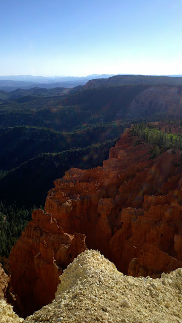 I'll post back here when I get the final files posted tomorrow. |
|
|
|
|
Logged
|
|
|
|
|
Topic Name: Dixie 200/311
|
Reply #57 on: June 19, 2012, 10:06:21 AM
|
kullaberg
Posts: 13
|
|
« Reply #57 on: June 19, 2012, 10:06:21 AM » |
|
Good news on the water, Dave.
Also looks like a change in weather is up for us. Better or worse?
|
|
|
|
|
Logged
|
|
|
|
|
Topic Name: Dixie 200/311
|
Reply #58 on: June 19, 2012, 12:01:27 PM
|
DaveH
Moderator
Posts: 975
|
|
« Reply #58 on: June 19, 2012, 12:01:27 PM » |
|
Better or worse? Hard to say, ask me next week Seriously, the area could use some moisture. Right now the forecast is only calling for a slight chance of thunderstorms, and a cooling trend from Sat->Mon. That sounds better in general - but if you get hit by a wet storm in an area of clay you might be better off to stay put for a couple hours while the moisture settles. Cooler will be better in the warmer areas (Red Canyon to Panguitch lake). Here are some more pics from the weekend. Crawford pass trail nice and clear through a tunnel of cut downed trees:  Water at water canyon on the Grandview:  Robinson Guzzler rain collected water. Lots of life in there... 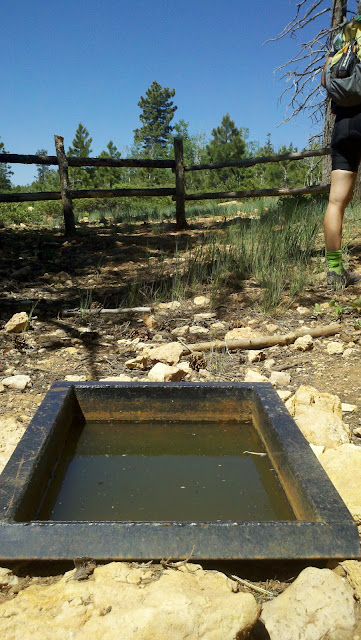 Heading down the final descent. This sign is no joke!  |
|
|
|
|
Logged
|
|
|
|
|
Topic Name: Dixie 200/311
|
Reply #59 on: June 19, 2012, 03:24:05 PM
|
LyndaW
Posts: 124
|
|
« Reply #59 on: June 19, 2012, 03:24:05 PM » |
|
Here are more pics and some commentary from me from our roaming around on the course last weekend http://2-epic.com/?p=1767It is so beautiful there. Now I want to come out and race it too!! It is a truly fantastic loop. |
|
|
|
|
Logged
|
|
|
|
|
|


