Topic Name: USA-WV-A Mountain Loop Topic Name: USA-WV-A Mountain Loop
|
on: April 28, 2012, 01:29:38 PM
|
jhl99
USA-PA-SW
Posts: 256

|
 |
« on: April 28, 2012, 01:29:38 PM » |
|
The popularity of doing ACA's Allegheny Mountain Loop (AML) as an ITT spurred me to lay out this route. Unlike the AML, this route stays within WV and includes stretches of single track. Some Pictures First: 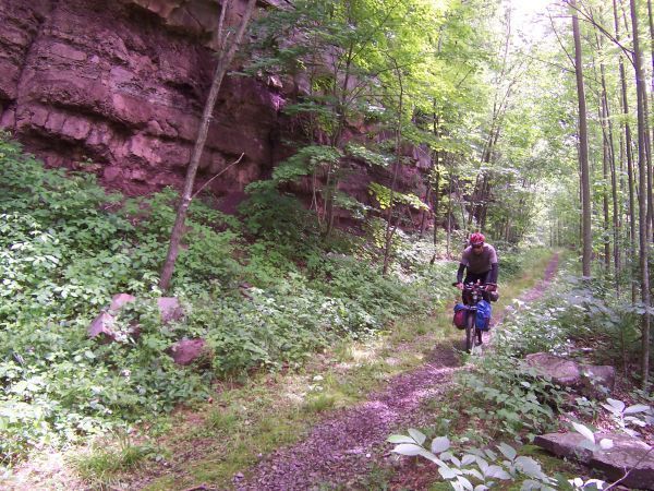 Rail trail in Blackwater Canyon 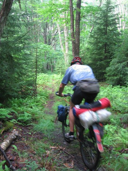 Allegheny Trail 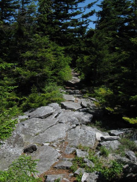 Huckleberry Trail 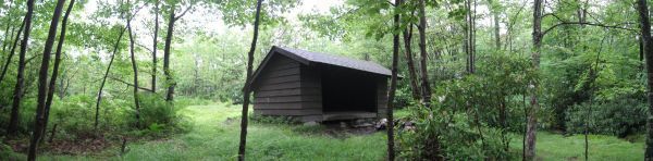 Shelter 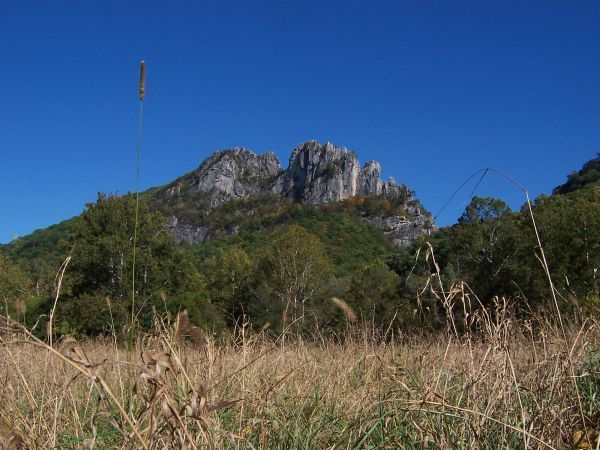 Seneca Rocks 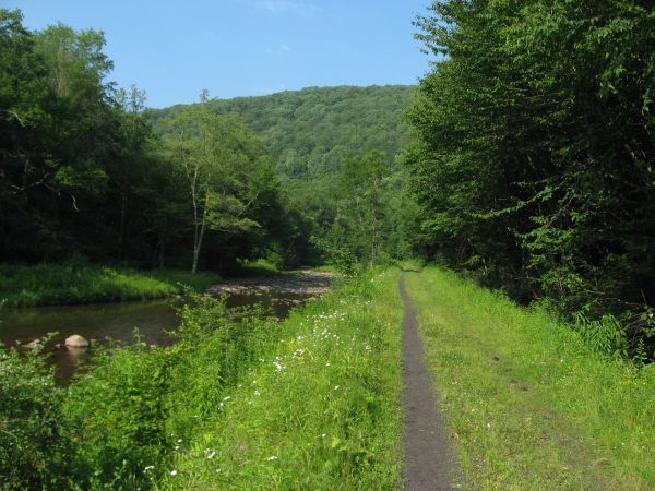 Greenbrier Rail Trail? or West Fork? 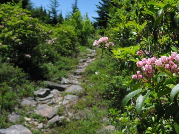 WV Rocks Map: https://www.google.com/maps/d/viewer?mid=zNaEaQkxnFRU.kX93osmoF1Cc(New Link 3/1/2015) Disclaimer: I haven't ridden all of this route, and for that matter, it may have been 15 years since I've been on the single track on Gauley Mountain, but I would not hesitate to attempt the route as presented. A few detours might be required, but knowing that up front mitigates the risk. HighlightsBlackwater Canyon Historic Coke Ovens along Blackwater Rail Trail Bald Knob lookout at top of Cass Scenic Railroad Spruce Knob: Highest Point in WV Huckleberry/Lumberjack/High Meadows Single Track North Fork Mountain Trail: 23 mile ridge run of ST View from N end of North Fork Mountain FR75 through the Sods NuancesUnsure if the Rail trail through Parsons is complete or takes surface streets. This is a trivial detail. Ford Greenbrier River S of Durbin, unknown. Water depth could be an issue. Jog onto FR115 after Red Spruce Knob… condition of FR115? Trail 333 is a wildcard Dotted trail on USGS 7.5’ map at miles 188-190 Single track or bushwhack? FR112 climbing to Spruce Knob is partially paved Known Grocery StoresParsons Durbin (assumed still open) Marlinton Davis Significant Omissions from routeTown of Cass More single track Extending the route into the Cranberry backcountry could add significantly more mileage, likewise crossing over into VA. If anyone was recommendations about improving the route, adding single track, please post up! |
|
|
|
« Last Edit: March 01, 2015, 06:03:20 AM by jhl99 »
|
 Logged
|
|
|
|
|
Topic Name: USA-WV-A Mountain Loop
|
Reply #1 on: April 30, 2012, 01:03:28 PM
|
swampboy62
Posts: 21
|
|
« Reply #1 on: April 30, 2012, 01:03:28 PM » |
|
First - you get around, bud. I keep seeing your posts when I check out my favorite places!
The loop - wow. That's a heck of a ride. All of N. Fork as a part of it, too - never been there on a bike, and have only seen a part of it, but I hear that's quite a ride. I see you also take the gravel road from route 32 all the way up past the edge of Roaring Plains/Dolly Sods. I've wondered if there's a way to connect up the Roaring Plains trails with the old road that leads up to the area from the south - that could be a cool part of a loop, since it would easily connect up with the Seneca Creek trail and then up to Spruce Knob (which I see you also have included).
I see Slatyfork on there, too! Plus Greenbriar rail trail. And the Allegheny Trail - heard some of that isn't too well maintained. Gotta say this would be an amazing loop. Thanks for your work - it gives me something to think about!
Steve Z
|
|
|
|
|
Logged
|
|
|
|
|
Topic Name: USA-WV-A Mountain Loop
|
Reply #2 on: May 01, 2012, 08:12:59 AM
|
swampboy62
Posts: 21
|
|
« Reply #2 on: May 01, 2012, 08:12:59 AM » |
|
Jeff,
I've been looking at your route a bit more. I may have mentioned that I was looking at making a Monongahela Nat'l Forest mtb map, so I have some background stuff done and a LOT of other maps/trails to look at.
Where you leave Parsons I was looking at a route that would connect up with route 33 east of Elkins. This route would involve taking FS roads through Fernow Exp. Forest, getting onto FS 324 which leads south quite a ways outside the western boundary of Otter Creek Wilderness Area. The road dead ends north of Bear Heaven a couple of miles, but the Nat'l Forest map and hiking guide shows Middle Point Trail that would connect up with FS 91 near the old lookout tower at Bickle Knob. This would eliminate the long paved/gravel road along Shavers Fork and that busy paved section of route 33.
Taking Glady Road south from route 33 looks like a pretty good paved road. The Allegheny Trail does run parallel to it, alongside Glady Fork, but I think that might be the section that was reported to be poorly maintained, with lots of downed trees.
Still digging into the details of your route. Nice job.
Steve Z
|
|
|
|
« Last Edit: May 01, 2012, 08:34:24 AM by swampboy62 »
|
Logged
|
|
|
|
|
Topic Name: USA-WV-A Mountain Loop
|
Reply #3 on: May 01, 2012, 09:01:33 AM
|
fotooutdoors
Posts: 206
|
|
« Reply #3 on: May 01, 2012, 09:01:33 AM » |
|
Wow. I lived just across the VA line back in college (Harrisonburg) and got out to that neck of the woods occasionally, and your route goes through some beautiful country. I really want to get down there and hit up one of my friends to give a part of this route a whirl.
As a note on the route, when I last hiked the North Fork Mountain trail (this was pre mountain-biking for me, about 5 years ago) the south end was posted for bikes, though hikers were allowed. Do you know if that has changed?
|
|
|
|
|
Logged
|
|
|
|
|
Topic Name: USA-WV-A Mountain Loop
|
Reply #4 on: May 01, 2012, 09:46:30 AM
|
jhl99
USA-PA-SW
Posts: 256
|
|
« Reply #4 on: May 01, 2012, 09:46:30 AM » |
|
Swamp: I did not consider connecting through Roaring Plains…. Unfortunately, the coolest route is to cross over the northern Sods to Timberline Ski area… except that block of land was converted to SFS Wilderness within the last decade… so no bikes. So it goes. The Allegheny Trail – In the past couple of years, I’ve reconned the northern parts of it. The sections included should be in good shape. See this thread: http://www.bikepacking.net/forum/index.php/topic,928.0.htmlFernow: I can’t remember if I’ve made that connection or not. I’m not against cruising along the Shavers Fork for some easy miles. Mainly because I think the big climbs later in the ride are somewhat intimidating. fotooutdoors: I’m not completely sure of the status of the S end of NorthFork Mnt Trail. The trail goes through private land. I’m not sure if there is an easement or not, and what the limitations may be. I’ve seen suggestions to carry your bike across the private land, otherwise, a detour is ride the valley road (east side of the mountain) and ride of the forest road that climbs to the ridge and then rejoin the single track. |
|
|
|
|
Logged
|
|
|
|
|
Topic Name: USA-WV-A Mountain Loop
|
Reply #5 on: May 02, 2012, 11:40:01 AM
|
paulmissoula
Location: Harrisonburg, Virginia
Posts: 61
|
|
« Reply #5 on: May 02, 2012, 11:40:01 AM » |
|
Awesome. Thanks for sharing. My family is from that area and I would love to do a bikepacking trip out there. Beautiful area for sure. Been looking at the AML but the singletrack on this is appealing.
What's the rideability of the singletrack portions you covered?
|
|
|
|
|
Logged
|
|
|
|
|
Topic Name: USA-WV-A Mountain Loop
|
Reply #6 on: May 03, 2012, 06:20:40 PM
|
jhl99
USA-PA-SW
Posts: 256
|
|
« Reply #6 on: May 03, 2012, 06:20:40 PM » |
|
Singletrack rideability: Depends on the individual. Some parts are fairly technical, others not as much. I'll readily admit that some of the super rocky stuff I just walk, although walking is sometimes just as tricky as attempting to pedal. Level of difficulty goes up when one is tired. I tried to avoid long ST uphills that might end up a push... not sure about Gauley Mtn stuff is a push or not. Probably most of the trails have been reviewed on MTBR.
|
|
|
|
|
Logged
|
|
|
|
|
Topic Name: USA-WV-A Mountain Loop
|
Reply #7 on: May 04, 2012, 07:38:33 AM
|
paulmissoula
Location: Harrisonburg, Virginia
Posts: 61
|
|
« Reply #7 on: May 04, 2012, 07:38:33 AM » |
|
Right on. Thanks for the info!
|
|
|
|
|
Logged
|
|
|
|
|
Topic Name: USA-WV-A Mountain Loop
|
Reply #8 on: July 09, 2012, 03:10:26 PM
|
ruthslp
Posts: 57
|
|
« Reply #8 on: July 09, 2012, 03:10:26 PM » |
|
JHL  |
|
|
|
|
Logged
|
|
|
|
|
Topic Name: USA-WV-A Mountain Loop
|
Reply #9 on: July 24, 2012, 03:57:42 AM
|
KyleWingler
Posts: 6
|
|
« Reply #9 on: July 24, 2012, 03:57:42 AM » |
|
I have done sections of your ride twice in the past month on a shorter 80 mile loop , I start in Davis and ride the Canaan loop road to a gated FS road along red run to the dry fork ,then ride CR 12 from jeningston to Alpena gap ,we stay at bear haven .on the second day we ride the stuart knob road to the middle point trail. We do 2 mile flat hike a bike traververse to the McGowan mt rd ,then it is a 14 mile downhill through the fernow experimental forest to parsons ,then we take the rail grade to henricks (which is complete ) then turn up the black water all the way to Thomas then road to Davis . It is an incredible ride ,I some of your route when I was planning my route , I hope to upload my gps files and pics to the site soon ,I am hooked on bike packing , I leave for Alaska tomorrow and I am taking my gear for more bike packing
|
|
|
|
|
Logged
|
|
|
|
|
Topic Name: USA-WV-A Mountain Loop
|
Reply #10 on: August 07, 2012, 06:21:21 PM
|
jhl99
USA-PA-SW
Posts: 256
|
|
« Reply #10 on: August 07, 2012, 06:21:21 PM » |
|
Kyle: Glad that someone has made use of the info. I'm sure the forum would like to read about your trip to Alaska... post up! ----------- A couple more teaser pics... these are slightly off route, but where taken in the northern portion of the route in the Canaan Loop Road area: |
|
|
|
|
Logged
|
|
|
|
|
Topic Name: USA-WV-A Mountain Loop
|
Reply #11 on: August 30, 2013, 01:29:27 PM
|
naked indian
Location: Deltona, FL
Posts: 178

|
|
« Reply #11 on: August 30, 2013, 01:29:27 PM » |
|
I want the gpx for this route, pretty please with sugar on top.
|
|
|
|
|
Logged
|
|
|
|
|
Topic Name: USA-WV-A Mountain Loop
|
Reply #12 on: September 03, 2013, 04:53:44 PM
|
jhl99
USA-PA-SW
Posts: 256
|
|
« Reply #12 on: September 03, 2013, 04:53:44 PM » |
|
GPX Sent!
|
|
|
|
|
Logged
|
|
|
|
|
Topic Name: USA-WV-A Mountain Loop
|
Reply #13 on: September 04, 2013, 04:03:17 AM
|
jhl99
USA-PA-SW
Posts: 256
|
|
« Reply #13 on: September 04, 2013, 04:03:17 AM » |
|
The GPX is attached to this post for anyone else who might want it.
A few more disclaimers.... a group of us road parts of the route over Memorial Day, 2013. We encountered significant blow down along the Blackwater Rail Trail... left overs from hurricane Sandy. Unlikely that the Forest Service has the resources to clear the that part of the trail fully. The upper reaches, near Thomas where cleared... I suspect the whitewater boaters cleared a way so they could run the canyon.
Parts farther south did seem to experience the same amount of damage.
|
|
|
|
Logged
|
|
|
|
|
Topic Name: USA-WV-A Mountain Loop
|
Reply #14 on: October 09, 2013, 06:53:33 AM
|
CaseyF
Posts: 2
|
|
« Reply #14 on: October 09, 2013, 06:53:33 AM » |
|
Thanks for posting this jhl99! I recently rode about 100 miles of the last section of this route and have a few comments that might help others in route planning: note: I rode in the opposite direction of the intended route so that might effect some of the ride-ability of the trails. Day 1- my route: http://www.mappingsupport.com/p/gmap4.php?q=http://www.murkybox.com/Final_WVroute_firstday.gpxI started in Blackwater Falls State Park, this gave me a good place to leave my car, and someone to check in with(check in/out at the main lodge). It also meant that I could hop straight on a trail instead of having to ride the road. The trail(Allegheny Trail #701) was phenomenal in my opinion. I even met a bunch of members of the Student Consveration Association working on the trail. I eventually got off the trail and onto a paved backcountry road. This was also fantastic, very little traffic and absolutely beautiful. This eventually took me to Dolly Sods, which is always fantastic. All in all, it was great day. For a good, one night, out and back I would suggest doing this route and camping at the north side of Dolly Sods. Day 2- my intended route: http://www.mappingsupport.com/p/gmap4.php?q=http://www.murkybox.com/Final_WVroute_secondday.gpxDay two wasn't quiet so much fun. Again, I have to emphasize that I was doing this route backwards from its original intent. I had already made it about a mile up North Fork Mountain Trail on the first day in order to camp. This mostly consisted of walking my bike. Past this first campsite the trail got even rougher, it ended up taking me about 2 hours just to get to the ridge. It was substantially more pushing my bike than I was hoping for. The important thing to know about the North Fork Mountain Trail is that there is absolutely no water once you get on it... so you better be carrying a whole lot of water. For this reason I wouldn't suggest planning on camping on this section of the route. I probably wouldn't do it again approaching from the north, the ascent on the south end of the trail looks a lot more reasonable. All of that being said, the overlooks on the North Fork Mountain Trail are stunning and not to be missed. Near the end of the end of the day I hit the Little Allegheny Trail. I realize that the Little Allegheny Trail would be a fantastic connector trail to get you over toward the Spruce Knob network of trails. Unfortunately, the Little Allegheny Trail in its current form only vaguely resembles a trail. It is substantially overgrown with thorn bushes and other growth, and I'm fairly certain that the only reason it isn't completely overgrown is that it is used by one or more large bears(huge bear scat everywhere on the trail). The first mile of it(coming from the north) is exceptionally brutal and infuriating, it does however get better, but its still going to be a fair amount of pushing. I wouldn't completely advise against this trail, but you should know what you're getting yourself into. Once you get to the ridge things much better, the trail widens up to what appears to have been an ORV trail, which means that even though its overgrown it is plenty clear to ride. Eventually you will descend into the valley on the Horton Trail. The Horton trail is in a similarly abysmal condition to the Little Allegheny, but instead of being overgrown it is very very washed out. I wouldn't suggest riding on this trail just for good trail care reasons, but if you do ride on it you should be very careful |
|
|
|
|
Logged
|
|
|
|
|
Topic Name: USA-WV-A Mountain Loop
|
Reply #15 on: October 09, 2013, 05:48:38 PM
|
jhl99
USA-PA-SW
Posts: 256
|
|
« Reply #15 on: October 09, 2013, 05:48:38 PM » |
|
CaseyF: Nice report. I guess you didn't experience much blow down on North Fork Mnt--that is good. Regarding the Dolly Sods, it wasn't that long ago that the Northern section was NOT Wilderness and one could ride across the Sods and descend (or climb up) from Timberline Ski Area... The Allegheny Trail has been tamed somewhat, there didn't use to be 'the path to Grandma's house' where it intersects Canaan Loop Road... The last time I road 'the Little Allegheny Trail' (2009) I was N bound... the descent to county road 33/3 had major blow down with root balls and such sticking up in the air and some trail rerouting, but was not overgrown... Here are some pics from 2009 of N end of Little Allegheny maybe the trail was totally rerouted ? or maybe more trees came down (or was logged) and the area is regenerating? The dynamics of eastern trails are never ending. I'm glad that you more or less confirmed that riding the loop counter-clockwise is probably preferred  *** I fixed the Google Map Link in the original post to my current ISP and it works again *** |
|
|
|
|
Logged
|
|
|
|
|
Topic Name: USA-WV-A Mountain Loop
|
Reply #16 on: October 09, 2013, 05:56:39 PM
|
jhl99
USA-PA-SW
Posts: 256
|
|
« Reply #16 on: October 09, 2013, 05:56:39 PM » |
|
Might as well post this picture of the Blackwater Canyon in this thread too: And another side note, Bike Magazine November 2013 has an article about riding in Canaan Valley. |
|
|
|
« Last Edit: October 09, 2013, 06:03:02 PM by jhl99 »
|
Logged
|
|
|
|
|
Topic Name: USA-WV-A Mountain Loop
|
Reply #17 on: October 10, 2013, 06:39:39 AM
|
CaseyF
Posts: 2
|
|
« Reply #17 on: October 10, 2013, 06:39:39 AM » |
|
Here are some photos from my trip as well: Right before entering The Dolly Sods  The Dolly Sods gravel road  The view from North Fork Mountain Trail  Overgrown Little Allegheny Trail(It seems as though the upkeep of this trail has been largely abandoned)  |
|
|
|
|
Logged
|
|
|
|
|
Topic Name: USA-WV-A Mountain Loop
|
Reply #18 on: October 14, 2013, 12:42:25 PM
|
CWM
Posts: 2
|
|
« Reply #18 on: October 14, 2013, 12:42:25 PM » |
|
Sorry if this is obvious and I am being dense but I do not see the GPX file. Is this the same thing as the link above to Google maps? Thanks The GPX is attached to this post for anyone else who might want it.
A few more disclaimers.... a group of us road parts of the route over Memorial Day, 2013. We encountered significant blow down along the Blackwater Rail Trail... left overs from hurricane Sandy. Unlikely that the Forest Service has the resources to clear the that part of the trail fully. The upper reaches, near Thomas where cleared... I suspect the whitewater boaters cleared a way so they could run the canyon.
Parts farther south did seem to experience the same amount of damage.
|
|
|
|
|
Logged
|
|
|
|
|
Topic Name: USA-WV-A Mountain Loop
|
Reply #19 on: October 15, 2013, 11:30:24 AM
|
jhl99
USA-PA-SW
Posts: 256
|
|
« Reply #19 on: October 15, 2013, 11:30:24 AM » |
|
GPX is attached to reply #13
|
|
|
|
|
Logged
|
|
|
|
|
|