 Topic Name: Route ideas for New England/Upstate NY ? Topic Name: Route ideas for New England/Upstate NY ?
|
on: October 02, 2008, 04:57:27 PM
|
LiMoDad
Location: Vermont
Posts: 33

|
 |
« on: October 02, 2008, 04:57:27 PM » |
|
Hi, I live in Northern Vermont and I'm seeking ideas for trips in VT,NH,ME & upstate NY. Weekend or multi day.
|
|
|
|
« Last Edit: October 03, 2008, 12:22:12 AM by Fat Hairy »
|
 Logged
|
|
|
|
|
Topic Name: Route ideas for New England/Upstate NY ?
|
Reply #1 on: October 23, 2008, 07:57:35 PM
|
LiMoDad
Location: Vermont
Posts: 33
|
|
« Reply #1 on: October 23, 2008, 07:57:35 PM » |
|
Somebody posted this on MTBR. I thought I would cut and paste it over here. -------------------------------------------------------------------------------- For those of you who have Snowbikes, Maines hut trail system will allow us to ride the trails this year. I spoke to someone at the main office yesturday. Described the bikes my wife and I ride (Pugs w/Endos, 1x1 w/endo). As long as conditions allow, Snowbikes are welcome. The first hut at Poplar Stream Falls is a 2.5 mile ride in. The second Hut at Flagstaff lake will be finished this fall and opened Jan 9,2009. When finished it will be a 180 mile , 5 hut trail system. Each hut should be one, short days ride apart. More info on the huts @ www.mainehuts.org . |
|
|
|
|
Logged
|
|
|
|
|
Topic Name: Route ideas for New England/Upstate NY ?
|
Reply #2 on: September 08, 2009, 08:08:24 AM
|
bmike-vt
Location: Horgen, Switzerland
Posts: 1122

|
|
« Reply #2 on: September 08, 2009, 08:08:24 AM » |
|
old old thread... but wondering if they allow summer MTB?
have to check out the org website.
|
|
|
|
|
Logged
|
|
|
|
|
Topic Name: Route ideas for New England/Upstate NY ?
|
Reply #3 on: September 08, 2009, 10:58:31 AM
|
jonesy792
Location: Tucson AZ
Posts: 201
|
|
« Reply #3 on: September 08, 2009, 10:58:31 AM » |
|
When I lived in Keene NH there was a unpaved rd./jeep trail that went to Gilsum (Old Gilsum Rd.). I was told that Old Gilsum connected to a network of trails+jeep roads that went all the way to the canadian border. I am not sure how accurate that is but I'm sure it would be worth looking into.
|
|
|
|
|
Logged
|
|
|
|
|
Topic Name: Route ideas for New England/Upstate NY ?
|
Reply #4 on: September 09, 2009, 06:52:15 AM
|
daveB
Location: Montpelier, VT
Posts: 78
|
|
« Reply #4 on: September 09, 2009, 06:52:15 AM » |
|
Years ago I lived in Hinsdale, NH, just across from Brattleboro. Old Northfield Road was a fun way of going south from town. There was also good riding of a loopy nature in Pisgah State Park. It would be cool to "discover" a Mass-Quebec route, just a ton of exploration necessary.
I'm in Montpelier, VT. A friend and I are actively exploring for bikepackable terrain around here...finding links between Class 4 roads, VAST (snowmachine) trails, and the occasional modern singletrack bit.
|
|
|
|
|
Logged
|
|
|
|
|
Topic Name: Route ideas for New England/Upstate NY ?
|
Reply #5 on: September 09, 2009, 02:45:01 PM
|
bmike-vt
Location: Horgen, Switzerland
Posts: 1122
|
 |
« Reply #5 on: September 09, 2009, 02:45:01 PM » |
|
DaveB - mikeb here from the 300k. I'm not actively seeking yet - but have been studying maps and topos. Best canned route I've found is the BayleyHazen military road - but it is more dirt road than trail. Been peeking around the ADVrider website (motorcycles) and if desperate enough will join VAST or VASA. Would love to see a statewide Class4 and ATV map. Or any effort to sketch some routes out. With our terrain here ther has to be something out there for 2-3 days of riding. I'd love to see some sort of Catamount trail for MTBs. Would be a summer use of the trail. Perhaps link up rideable sections with dirt / ATV? I'll drop you an email. I'm just retruning to the woods from too long on the road. (Plenty of dirt and gravel around that I've found.)
|
|
|
|
|
Logged
|
|
|
|
|
Topic Name: Route ideas for New England/Upstate NY ?
|
Reply #6 on: September 12, 2009, 04:43:29 PM
|
jhl99
USA-PA-SW
Posts: 256
|
|
« Reply #6 on: September 12, 2009, 04:43:29 PM » |
|
I think pretty much the complete snowmobile network in the Adirondacks is fair game (within the Blue Line). Some snowmobile trails are essentially single tracks when the snowpack is gone. I've done trips that link shorter sections of ST with roads, but never ST only. There lots of lean tos in the Wild Forest areas (ATB legal). You can get a complete GIS CD-ROM from the park agency for something like $10.
|
|
|
|
|
Logged
|
|
|
|
|
Topic Name: Route ideas for New England/Upstate NY ?
|
Reply #7 on: September 17, 2009, 09:18:22 AM
|
bmike-vt
Location: Horgen, Switzerland
Posts: 1122
|
|
« Reply #7 on: September 17, 2009, 09:18:22 AM » |
|
I think pretty much the complete snowmobile network in the Adirondacks is fair game (within the Blue Line). Some snowmobile trails are essentially single tracks when the snowpack is gone. I've done trips that link shorter sections of ST with roads, but never ST only. There lots of lean tos in the Wild Forest areas (ATB legal). You can get a complete GIS CD-ROM from the park agency for something like $10.
poking around for ADK info - it seems many wilderness areas are OK to cross on a snow machine in the winter - but are off limits to MTB in other seasons. it varies by area of the park, from what i can tell. i have a snowmobile trail map coming in the mail. and i'll have to dig for more info on the legality of riding which trails / etc. from my road rides there (dirt, paved) it seems many of the winter trails would be tough to follow in the summer or fall... overgrown, cross private property, etc. etc. but - heading in to lean to's or primitive camp sites would be something i've wanted to do for quite some time. i've been exploring new dirt roads each time i get to ride... so much terrain, so close by. |
|
|
|
|
Logged
|
|
|
|
|
Topic Name: Route ideas for New England/Upstate NY ?
|
Reply #8 on: September 19, 2009, 07:51:18 PM
|
jhl99
USA-PA-SW
Posts: 256
|
|
« Reply #8 on: September 19, 2009, 07:51:18 PM » |
|
I don't think you will find that snowmobiles are allowed in ADK wilderness. The 5 or 6 million? acres of the ADK are highly regulated by land-use classifications. No Snowmobiles or bikes in wilderness areas.... but areas classified as 'Wild Forest' permit bikes and snowmobiles. One thing, many snowmobile routes lead to you to water... or a frozen lake in winter, so those spurs aren't particularly useful for summer biking. Over the years, I've spent maybe 5 weeks mountain biking the Adirondacks. A few pics from last year's trip: Typical Adirondack style shelter. If memory serves, there are something like 200 of them scattered about the park. 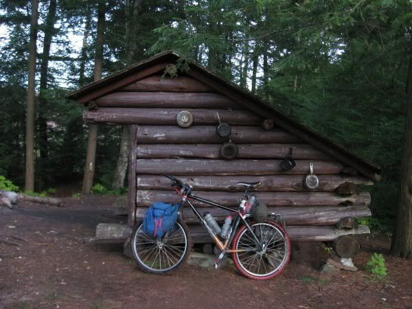 Roadside Scenery: 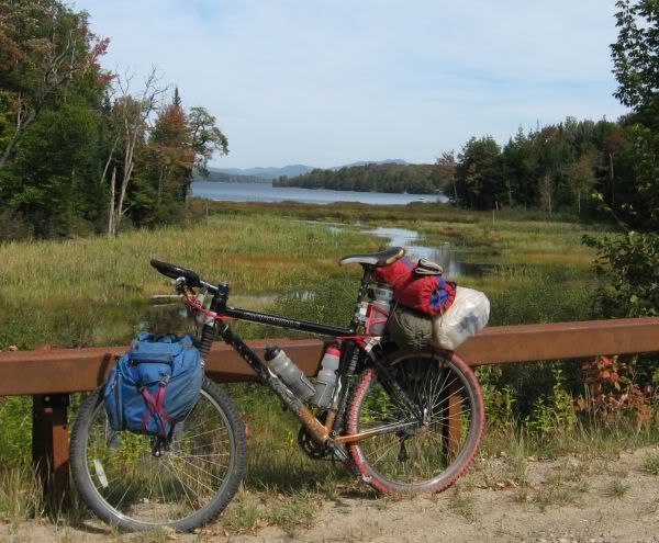 Along a trail. Blowdown can be an issue. Tree roots don't hold well in the sandy, glaciated soil, so if there is a big blow, trees come down. 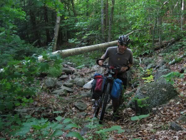 |
|
|
|
|
Logged
|
|
|
|
|
Topic Name: Route ideas for New England/Upstate NY ?
|
Reply #9 on: September 22, 2009, 05:19:47 AM
|
bmike-vt
Location: Horgen, Switzerland
Posts: 1122
|
|
« Reply #9 on: September 22, 2009, 05:19:47 AM » |
|
Nice pics. I get over through the park a few times a year. Been doing a yearly 300k road / dirt ride from BTV to my in-laws in upstate. Great great place to explore. Pulled my Gazetteer and some Topos last night. Plenty of dashed 'unimproved road or trail' markings. Might have to basecamp and explore. I have run into plenty of private roads and gates though (Tupper Lake area)...
|
|
|
|
|
Logged
|
|
|
|
|
Topic Name: Route ideas for New England/Upstate NY ?
|
Reply #10 on: September 22, 2009, 08:48:22 AM
|
LiMoDad
Location: Vermont
Posts: 33
|
|
« Reply #10 on: September 22, 2009, 08:48:22 AM » |
|
If anybody is looking for company on a trip or route exploration (winter or summer) please PM me. I'm not the strongest or fastest rider but I'll carry the beer.  |
|
|
|
|
Logged
|
|
|
|
|
Topic Name: Route ideas for New England/Upstate NY ?
|
Reply #11 on: September 22, 2009, 05:56:16 PM
|
jhl99
USA-PA-SW
Posts: 256
|
|
« Reply #11 on: September 22, 2009, 05:56:16 PM » |
|
One thing I forgot to mention, there are 2 mountain biking books on the Adirondacks, one by Kick and one by Thoman. The books give routes for shorter rides (maybe 20 miles) but you can link them together via roads for longer tours.
BmikeVT - The SW portion of the park seems to be the better area, so Tupper is a good base, around Placid, there isn't much because of all the High Peaks. I've had good luck around Old Forge, Woodgate, Cranberry Lake, Moose River Plains, etc. Generally the rides are probably 80% road or dirt and 20% trail and 2-3 days in duration.
The park would be a great place for a long distance trail, but I don't think there are enough bikers in the area to develop or support a lengthy trail. There is that long hiking trail (Northville-Placid?) but I'm pretty sure it is no bikes allowed.
|
|
|
|
|
Logged
|
|
|
|
|
Topic Name: Route ideas for New England/Upstate NY ?
|
Reply #12 on: September 23, 2009, 06:51:51 AM
|
bmike-vt
Location: Horgen, Switzerland
Posts: 1122
|
|
« Reply #12 on: September 23, 2009, 06:51:51 AM » |
|
yeah, i've been studying the southern part of the park. high peaks is pretty tough. not enough connecting dirt roads. and all those tourists. i've done some nice canoe / kayak primitive camping at lake lila. they added a better parking lot and permanent composting outhouses in the last 3-4 years -which has upped its popularity. - but the first 3 times i was there it felt pretty remote. hike in to maybe 2 decent sites, canoe in to the nice stuff - and you can't park at the water - so 1/2 mile portage just to get started. deters quite a few folks.  . there is a gated road that gets you to the far side of the lake. no lean tos - but some campsites accessible from the road. have a plan to ride there from burlington next fall(ish). would be 200k from here. pave to get to the park, then try to link up as much dirt road as i can. don't see many options for trails - but when i last hiked the mountain near the lake there were some mtb folks staying on private camp land way back in there. they were riding some of the trails... i'd have to research that area. lots and lots of posted signs way back in the woods in may parts of the park. gets the nerve up a bit when trying to connect a hiking trail or when you get lost. |
|
|
|
|
Logged
|
|
|
|
|
Topic Name: Route ideas for New England/Upstate NY ?
|
Reply #13 on: September 23, 2009, 06:54:44 AM
|
bmike-vt
Location: Horgen, Switzerland
Posts: 1122
|
|
« Reply #13 on: September 23, 2009, 06:54:44 AM » |
|
wondering how a pugs would do on many of the abandoned rail lines. i think these get used for snow machine in the winter... i know there is a spur that runs west of tupper / sabbattis / etc. walked a long section of it 3-4 years ago. would be rough on my crosscheck or IF. might be doable on a proper MTB. endomorphs would probably float over the ties.
|
|
|
|
|
Logged
|
|
|
|
|
Topic Name: Route ideas for New England/Upstate NY ?
|
Reply #14 on: October 05, 2009, 09:51:43 AM
|
daveB
Location: Montpelier, VT
Posts: 78
|
|
« Reply #14 on: October 05, 2009, 09:51:43 AM » |
|
Greetings adventurous mountain bikers! www.audaxvermont.com, champion of long distance cycling and randonneuring, is starting to create a new biking route in Vermont, the XVT. We want your experience, your local knowledge, and your interest in pouring over maps, to help pick the best existing roads and trails. This is not about trail building, this is about creating a beautiful, fun, and challenging long distance mountain biking route to be done either in sections or in its entirety. XVT A mountain biking route that loops around Vermont, from Massachusetts to Canada and back, on as much dirt as possible. Most of the route is local town maintained dirt roads in good condition. Rougher Class 4 roads will be incorporated whenever possible. VAST trails will be included when trail surface is reasonable for summer travel. Singletrack that is point-to-point will be included as much as possible. Paved roads will be avoided. There are no markers on the ground, no maintenance assurances, and no one who can provide directions or support. Be prepared and self-sufficient. Enjoy maple creemees and whoopie pies at local stores. Locations and land that permit tent camping and fee campgrounds on route will be identified to facilitate bikepacking. However, the majority of the route abuts private land that may be posted. Camping in those areas will require considerable prudence and stealth. Route will probably be 450-500 miles. For development purposes, the route will be broken into seven zones: 1 Canada- Rt 2 (east) 2 Rt 2-Rt 4 (east) 3 Rt 4-Rt 9 (east) 4 Rt 9-Mass-Rt 9 5 Rt 9-Rt 4 (west) 6 Rt 4-Rt 2 (west) 7 Rt 2-Canada (west). Please comment by zone to make collating with others easier. Text, maps, www.bikely.com links, and .GPX files all acceptable. We hope to produce cue sheets and .GPX files for the entire route. Zone: Suggested route ideas: Specific roads/trails the route MUST include: Camping opportunities: Reply via email using the bullet items above as a template, or look at http://xvtmbr.pbworks.com/Using this wiki will allow multiple people to contribute ideas in an orderly manner and keep our inboxes from getting out of hand. Email Dave Blumenthal ( dave@studiozoic.com) to be added to the list of approved contributors, then you'll be able to add your own ideas. Get out the maps and thanks in advance for your contributions! Audax Vermont Dave Tremblay ( tremblay@madriver.com) Dave Blumenthal ( dave@studiozoic.com) |
|
|
|
|
Logged
|
|
|
|
|
Topic Name: Route ideas for New England/Upstate NY ?
|
Reply #15 on: October 15, 2009, 11:54:08 AM
|
bmike-vt
Location: Horgen, Switzerland
Posts: 1122
|
|
« Reply #15 on: October 15, 2009, 11:54:08 AM » |
|
Just picked up the 'TrailsIllustrated' NG maps of the southern ADKs. Quite a few trails that link dirt roads and are marked snow mobile or bike.
Going to explore the Moose River Plains area next summer via the road bike on my way to my inlaws from BTV to Utica. Hopefully will add in an extra day or two with a base camp between Speculator and Inlet to explore.
daveB - nice looking project. I'll have to log onto the project site after I get my RUSA / ACP brevet submissions for '10 done.
|
|
|
|
|
Logged
|
|
|
|
|
Topic Name: Route ideas for New England/Upstate NY ?
|
Reply #16 on: October 15, 2009, 12:52:37 PM
|
daveB
Location: Montpelier, VT
Posts: 78
|
|
« Reply #16 on: October 15, 2009, 12:52:37 PM » |
|
I was in Big Moose for a week this summer and did some exploring. I picked up a sketch map at "Petals and Pedals", the flower shop/bike shop in Inlet. Not exactly the most useful shop. The local chamber of commerce says that they have lots of mtb trails, but that committee must be made up of snowmobilers, since that's what the trails are. The route from Big Moose Lake-West Pond-Safford Pond-Lake Rondaxe was rather unpleasant. The "trail" was 25' wide, but knee high weeds everywhere, and hundreds of yards of walking through high-shin-deep water that is obviously frozen in winter.
Another trail closely paralleling NY28 there was freshly graded (read SOFT). And since it was only 10' from the road, I really wanted my road bike. Another logging type road went from the village of Big Moose SW towards Old Forge: standard good condition wide logging road.
Other mtb "trails" in the vicinity are pretty much gravel logging roads. Trails noted as "advanced" I think are ATV trails, and may not be the nicely bermed flowy singletrack you're hoping to stumble on.
At least in that area, I'd stick to the dirt roads.
|
|
|
|
|
Logged
|
|
|
|
|
Topic Name: Route ideas for New England/Upstate NY ?
|
Reply #17 on: October 15, 2009, 01:47:24 PM
|
bmike-vt
Location: Horgen, Switzerland
Posts: 1122
|
|
« Reply #17 on: October 15, 2009, 01:47:24 PM » |
|
daveB - no doubt what is considered 'trail' is loosely defined in the ADKs. I'd love to connect Moose River Plains with Rt 8 to the south but this crosses the West Canada Wilderness and bikes are verboten. It looks possible with a longish carry on the NP and Sucker Brook trail to Lewey Lake.
I think a better option might be cross bike for dirt and gravel and pack raft. A true traverse would be possible of more of the park.
|
|
|
|
|
Logged
|
|
|
|
|
Topic Name: Route ideas for New England/Upstate NY ?
|
Reply #18 on: July 29, 2011, 06:19:33 AM
|
bmike-vt
Location: Horgen, Switzerland
Posts: 1122
|
|
« Reply #18 on: July 29, 2011, 06:19:33 AM » |
|
Just an update, and DaveB, I only met you a few times, but you are missed. Here's a link to geodata for the NY DEC. http://www.dec.ny.gov/geodata/ptkI've brought this into GoogleEarth, and then selected portions of MTB trail, forest road, etc. to put together portions of a ~230mile route I hope to do in August. (I've done a double century paved route 3 years ago, but want to hit some dirt areas this time through) Here's the middle of the route - from Indian Lake follow into Cedar River on dirt road, which turns to Moose River Plains Road, then on to the Otter Brook Truck Trail - which is an old logging road, currently being debated on being turned into a bike corridor adjacent to a Wilderness Boundary. From what I've found online, the truck trail goes from double track to 'hiking' trail / sno-mo trail and back. I'd then reconnect to the MRP road, and on up to Rt 28 for some pavement. From there, I turn back east and follow a logging road / bike trail to Woodhull lake, then mtb trail / hiking trail to Sand Lake Falls Lean To and on to North Lake and South Lake, where I pick up what looks like logging road / dirt road. Some more pavement, and then 20 miles of the Powley Road, which passed through Wild Forest. 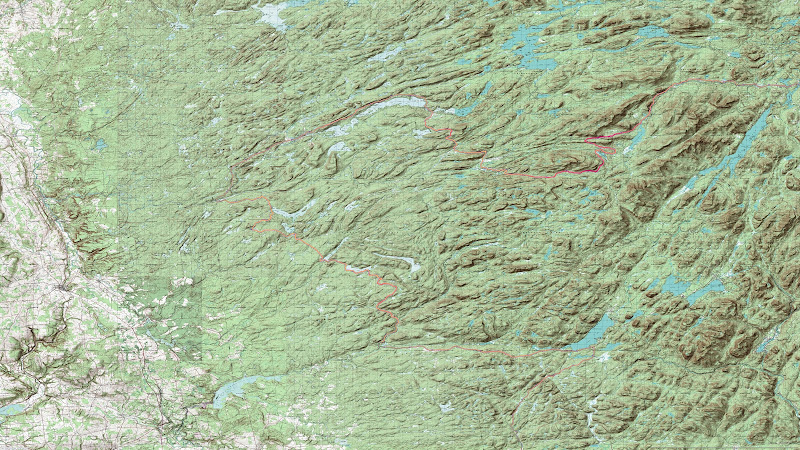 Pic from a winter Pugsley trip on the Moose River Road near the western side:  |
|
|
|
« Last Edit: July 29, 2011, 06:26:38 AM by bmike-vt »
|
Logged
|
|
|
|
|
Topic Name: Route ideas for New England/Upstate NY ?
|
Reply #19 on: July 29, 2011, 10:12:14 AM
|
jhl99
USA-PA-SW
Posts: 256
|
|
« Reply #19 on: July 29, 2011, 10:12:14 AM » |
|
btmike:
Thanks for the the update, both here and in my trip report regarding Geo Data for the ADKs. The NY DEC/Adirondack Part Agency does a great job of putting the data out there for the public.
I don't have my maps/computer with me, but I know I've been to Woodhull lake, If I remember correctly, it is a well used area. Gull lake is less so. There are lean tos at Gull and Woodhull (at least 5 years ago or so).
If you are agreeable, I could compare your track agains my historical data to see if I can give you any feedback... send me a PM if interested.
JHL99
Since I travel from PA to get the ADKs, I did most of intial trips starting in the SW corner... because it was closest to home.
|
|
|
|
|
Logged
|
|
|
|
|
|


