Topic Name: Monongahela National Forest, WV Topic Name: Monongahela National Forest, WV
|
on: July 04, 2009, 11:49:45 AM
|
jb1speed
Posts: 4

|
 |
« on: July 04, 2009, 11:49:45 AM » |
|
Hi,
Has anyone had any luck piecing together a 7-10 day-ish trip together in the Monongahela National Forest? I'm planning on heading out there at the end of august. I know there are tons of trails there, but I'm not familiar with them and I am unsure of how to piece together this trip. I'd like to ride as much single track as possible. I'm ok with riding closed forest service roads and old railroad grade trails to get to the single track, but I would like to spend most of my time on single track. Any help would be much appreciated! thanks!
-Jonathan
|
|
|
|
|
 Logged
|
|
|
|
|
Topic Name: Monongahela National Forest, WV
|
Reply #1 on: July 06, 2009, 09:42:28 AM
|
jhl99
USA-PA-SW
Posts: 256
|
|
« Reply #1 on: July 06, 2009, 09:42:28 AM » |
|
Where are you from? How familiar are you with the area? Point to point or loop ride? Do you like roots and rocks? Here is link to a post I did a one day ride I just did a week ago (check the links for google map and pics) http://www.dirtragmag.com/forums/showthread.php?t=20749Places I would include: 1. Spruce Knob 2. Cass 3. Seneca Rocks 4. North Fork Mtn Trail 5. Canaan Road Area 6. Northern Dolly Sods 7. Durbin/Beemis (?) Rail Trail 8. Maybe parts of Greenbrier Rail Trail 9. Trails around Slatyfork 10. Blackwater Canyon 11. Towns to visit: Lewisburg, Marlington, Davis Note, some of the above points are interest are not necesarrily backcountry places, but still worthwhile. The rockiness of some trails cannot be underestimated, what looks line a level trail on a topo can be brutally rocky, it would be good to have some contingency plans... I'm most familiar with the northern MNF... also, I would try to work in the New River Gorge and Cranberrry Backcountry if I could. The Allgheny trail pretty much spans the MNF, I do not have info on the whole route. |
|
|
|
« Last Edit: July 06, 2009, 09:48:53 AM by jhl99 »
|
Logged
|
|
|
|
|
Topic Name: Monongahela National Forest, WV
|
Reply #2 on: July 08, 2009, 02:53:13 AM
|
jb1speed
Posts: 4
|
|
« Reply #2 on: July 08, 2009, 02:53:13 AM » |
|
I'm from ohio, but live in canada now. So I am comfortable with rocks and roots. There are tons up here in with the canadian shield and all. I am also prepared to hike-a-bike if need be.
Here is my tentative plan:
It will be a loop-like ride. I think I will start in Davis, and bike in canaan/blackwater area some.
Then head to Dolly Sods North (Do you know of any maps available for this trail network).
Then I'll get to bemis/glady, and bike to durbin, bike in and around Cass (What are the good trails in cass?).
Then I need to find a way to get to slaty fork. Bike slaty fork.
Head to Greenbriar rail trail, bike that.
Get to spruce knob somehow, bike there, and then head back to Davis.
Should be an adventure to say the least!!
Are you allowed to bike on the Allegheny trial? What are the rules on biking on trails? Are most national forest trails open to bikes? Or just a select few?
Where is the North Fork Mtn trail??
|
|
|
|
|
Logged
|
|
|
|
|
Topic Name: Monongahela National Forest, WV
|
Reply #3 on: July 09, 2009, 09:30:12 AM
|
jhl99
USA-PA-SW
Posts: 256
|
|
« Reply #3 on: July 09, 2009, 09:30:12 AM » |
|
It sounds like a plan is forming.  You should be able to find a place at leave a car for an extended time without much hassle around Davis. Both Blackwater Falls State Park and Canaan Valley SP have lodges and you can probably leave a car in the parking lot without much issue. I've left a car at the Blackwater State Park lodge for weekend rides without issue (and without asking). Failing all else, Roger Lilly at Blackwater Bikes might be helpful. Here is something to get you started http://mysite.verizon.net/vzesg98g/tour_canaan_valley.pdf, I wrote that some years ago, but it might help. From Dolly Sods, N, you might want to drop off the mountain down to Hopeville, WV and take county roads to Smoke Hole and pickup of N Fork Mountain Trail. N Fork Mnt is a long, single track ridge ride (no water on it, only bad thing)... N. Fork Trail will dump you out on US33 W of Franklin. Then roads to Bemis and Rail Trail, although there might be ST opportunity in between instead of taking US33. Cass neat because it is restored lumber town and there is an exursion steam engine. It is also the norther terminus of the Greenbrier Rail Trail. I did a tour once where I road up part of the RR tracks (RR tracks with switchbacks are unique!) did some bushwhacking and made it to the top of the mountain where the exursion train goes. From the top, in theory, I think, you can hook up with the Snowshoe trails (I've never done this) and then get over to Slatyfork. Allegheny Trail - I'm not sure all sections, but some some sections bikes are ok MNF - no bikes in Wilderness areas You might want to get a copy of the MNF hiking guidebook. Also, you should find some info on MTBR.com regarding Slatyfork, I think those guys have had group rides there. |
|
|
|
|
Logged
|
|
|
|
|
Topic Name: Monongahela National Forest, WV
|
Reply #4 on: July 13, 2009, 01:18:44 AM
|
jb1speed
Posts: 4
|
|
« Reply #4 on: July 13, 2009, 01:18:44 AM » |
|
Thanks Man!
I better get some miles in me before this trip, so I can hit all these trails.
Here is my plan so far. Canaan forest road 13, to plantation trail, to tr 701. Then head through Laneville area to Dolly Sods North. I'm still cannot find a map of Dolly Sods North. Do you know where exactly to pick up the trails? and Where they Dump you out? Are they the hiking trails immediately north of the wilderness area? I have the hiking guide, so I've been using that some.
Then I'll do like you suggested and head to franklin via north fork mountain trail. Then get to Bemis via fire and county roads. Ride to Cass. Somehow ride to slaty fork. Ride there and maybe camp a night or two in Cranberry Backcountry. And really leave this open part open for a ton of riding. Then ride to Mill point and then Marlington. And ride south along Greenbriar rail trail. Then maybe ride around near White Sulphur Springs (if there is anything there). Then head back to Davis via greenbriar rail trail to bemis, then allegheny trail from bemis to davis. I wonder how many miles this will be, and if it is doable in 7 days.
Should be pretty excellent. I'll have to post a trip report somewhere.
|
|
|
|
|
Logged
|
|
|
|
|
Topic Name: Monongahela National Forest, WV
|
Reply #5 on: July 14, 2009, 12:23:37 PM
|
jhl99
USA-PA-SW
Posts: 256
|
|
« Reply #5 on: July 14, 2009, 12:23:37 PM » |
|
7 days might be a little aggressive, depending on what shape you are in. Years ago, I did a loop (no single track, just paved, dirt roads and rail trail) Basically Davis-Seneca Rocks-Lewisburg-Greenbrier RT--Beemis--Parsons and back I think it was 6 days 5 nights.. spent 1/2 day riding to top of Cass... I think 55-60 miles a day average. My rig was basically convential touring on a mountain bike (low riders, front panniers, rear rack and small rear panniers, not ultralight). The WV singletrack would have slowed me down significantly.
A few route comments...
I can't remember which sections are most brutal, but parts Plantation Trail can be brutal (I've never ridden the whole 6-7 miles or whatever it is). It is often referenced in lists of great mountain bike trails, not because it is fast and flowy, but because it is tough--slow and techincal. It is kind of ominous to lead off with that trail, but you can rest assured the single track will get easier. If memory serves, 701 is part of the Allegheny Trail. It starts a little rocky, but is a good ride. 701 can lead you into the back of Canaan Valley SP where you get water at the campground.
Rather than go to Laneville, you might want to go from Canaan Valley St Pk to over near White Grass Ski Touring area and take Forest Road 80 up to the top of the Sods (you come out near the top of the Timberline Ski Lifts), from there work your way accross the Northern Sods. Otherwise, you are kind of looping into the Sods and looping back out, nothing wrong with though. It isn't that far in on your route (maybe 30 miles) but there is some nice camping along Red Creek in the northern sods.
Did you notice my link?--the map on page 11 of the PDF shows Dolly Sods North above the Wilderness Area,and the associated trails in magenta color.
One thing I struggle with on this site is reading the reports from the guys out west. When I think about how they come up with hundreds of miles of ST for a tour and I try to picture doing that in the mid-atlantic, what comes to mind is that it wouldn't be that fun for me. (maybe it is the conditions in the east, maybe it is me, I'm not sure) Trying to ride exclusive singletrack would be slow and tough, day after day. I guess my point is that bring good documentation with you on your trip, because you might need to alter your plans once you find your pace. Fortunately, the nature of your route does intersperse roads with single track.
|
|
|
|
|
Logged
|
|
|
|
|
Topic Name: Monongahela National Forest, WV
|
Reply #6 on: July 19, 2009, 10:25:25 AM
|
jb1speed
Posts: 4
|
|
« Reply #6 on: July 19, 2009, 10:25:25 AM » |
|
I know what you mean about pace. I want to enjoy myself too. It is not all about pushing a hundred miles a day, with no time to at the end of the bike ride. I have 10 days to play with, and I'm trying to put in a bit of rail trail and forest road to break up the rocky single track. If I need a couple of slow days, I have the freedom to take a break, or just ride some forest roads or just go swimming or whatever.
I'm accustomed to rocks, but 20 miles of rocks are brutal and will make you cry for hard packed dirt or gravel. I also ride rigid single speed 29'er, so that makes the rocks that much more brutal! but that being said I'm used to rocks, but not WV rocks. I've ridden at Kanawah state forest and Mountwood a few times, but not in the Monongahela.
Your map of dolly sods north is helpful I'll have to use your route through the ski resort and up FR80. Are there places to camp on the North Fork mtn trail? Or would it be better to ride it all in one day starting from camping near red creek. I might end up having to camp near seneca rocks and pack in enough water for camping.
I know what you mean about the western trip reports. Different type of rocks? and trails? maybe? haha. I mean 100 miles a day is feasible, but your right it would take all day and be brutal. Especially if the trails are anything like Kanawah.
|
|
|
|
|
Logged
|
|
|
|
|
Topic Name: Monongahela National Forest, WV
|
Reply #7 on: July 20, 2009, 06:29:02 PM
|
jhl99
USA-PA-SW
Posts: 256
|
|
« Reply #7 on: July 20, 2009, 06:29:02 PM » |
|
Attached are some of my notes of campspots on North Fork Mnt Trail. Asking about campspots was a good question, sometimes it is to rocky for a ground tent. A couple of camp spots near the North end of North Fork Mnt Trail. Note that is a about 2800' vert from the river elevation. That is pretty much a push your bike type of climb. The views from where the map is marked 'cliff' are pretty good. Once you get to the top, as I recall, the trail isn't that bad, except for a lack of water.. I remember reading that those who ride the trail in a day normally shuttle cars. 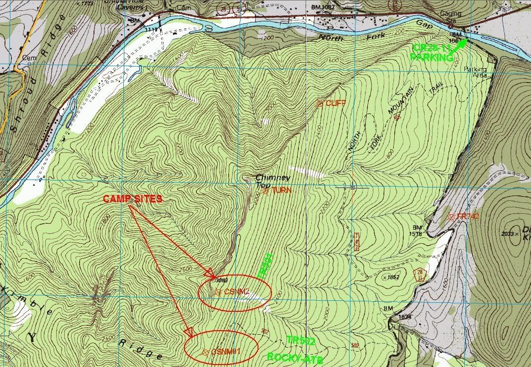 Farther to the south, maybe 1/2 of the way south I marked another spot: 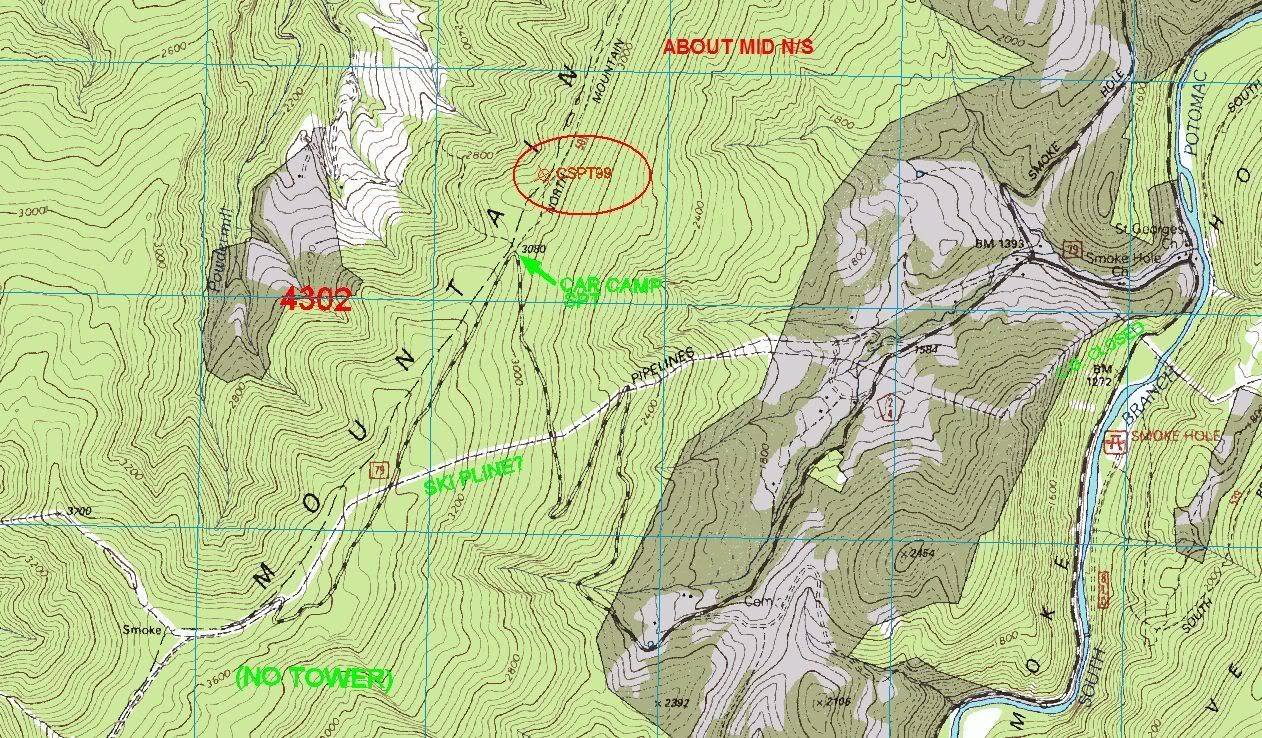 Note that ther is a FR79 that drops down to the East. That could be used as a bailout to get back to roads if required. I've ridden the complete trail, but only 1/2 at a time, using FR79 to make loops with the the roads in the valley. It is hard to judge the best way to plan this part of your ride. I would think that Red Creek to up to the top of North Fork Mnt would be doable in day. The climb up will take a while, then ride as far south as possible. If it comes to it, camp right on the trail, it is unlikely you will run into anyone up there. |
|
|
|
|
Logged
|
|
|
|
|
|