 Topic Name: Kern Plateau (Southern Sierras) Topic Name: Kern Plateau (Southern Sierras)
|
Reply #40 on: November 24, 2016, 01:44:58 PM
|
Michael_S
Location: Carlsbad Ca.
Posts: 76

|
 |
« Reply #40 on: November 24, 2016, 01:44:58 PM » |
|
Some interesting routes for sure. The weather can be a factor in May down in the Kernville area. It can be 90-100 degrees by then. It's nice to stay in the higher country as much as possible.
There is some nice singletrack from Camp Nelson up to Quaking Aspen and then down thru the Freeman Creek Grove. The semi paved road to Lloyd Meadow could be used to come back to Johnsondale
mike
|
|
|
|
|
 Logged
|
|
|
|
|
Topic Name: Kern Plateau (Southern Sierras)
|
Reply #41 on: November 25, 2016, 09:33:13 AM
|
ec_duz_it
Location: Santa Barbara
Posts: 440

|
|
« Reply #41 on: November 25, 2016, 09:33:13 AM » |
|
Mike, I agree. It can get in the high 80s or 90s by late May in the lower elevations. Miles 93 through 124 would be much better in the early morning or late evening, and that would definitely be part of the strategy. The first time I rode Kern River Trail it was entirely at night, and its not overly technical, so its pretty safe to ride at night. Keyesville, Kern River Trail, and Badger Gap trails all combined are almost 30 miles of really great singletrack and not to be missed.
|
|
|
|
|
Logged
|
|
|
|
|
Topic Name: Kern Plateau (Southern Sierras)
|
Reply #42 on: December 07, 2016, 12:42:02 PM
|
evdog
Location: San Diego
Posts: 373
|
|
« Reply #42 on: December 07, 2016, 12:42:02 PM » |
|
Evedog, your loop idea sounds more interesting than the loop I had in mind. I havent yet explored the area you are referring to. As you know, the routing possibilities here are endless!   Just fyi, 3 trails that are in terrible shape right now are lower tobias, bitter creek, and summit trail. These should all be avoided until they see some serious maintenance. Bitter Creek will probably always be bad. It is just too sandy and sloppy. Thanks for info on Tobias and the others. I haven't been on it in almost 2 years. It was passable then but not many people ride it and only a small number maintain it, it gets overgrown quickly. The southern loop interests me mainly because it would avoid the need for a massive shuttle. It would have a fair bit of pavement to connect dirt sections, and most of the rest would be dirt unless I can find some better connections. Most of the singletrack is moto trail and would be too steep to be fun for bikepacking. But it may be possible to get a few sections in. I need to get back into mapping mode! |
|
|
|
|
Logged
|
|
|
|
|
Topic Name: Kern Plateau (Southern Sierras)
|
Reply #43 on: December 07, 2016, 07:41:01 PM
|
ec_duz_it
Location: Santa Barbara
Posts: 440
|
|
« Reply #43 on: December 07, 2016, 07:41:01 PM » |
|
Evandog, here is the loop I was thinking. It is a much bigger version of the figure 8 loop I posted here a while back: https://ridewithgps.com/routes/18008615Upper Tobias Trail is currently pretty good, so that is included, but lower Tobias is avoided and instead head north to Johnsondale for re-supply. Another option there would be Pup Meadow trail and then over to Johnsondale via the fireroads in that area. Summiting Sherman Peak is included. Both times I rode up Sherman Pass Road I summited Sherman Peak. After a 6000 ft climb up the pavement, another 500 ft climb to top out on the summit feels like good achievement. The trail up to Sherman Peak is not the best though and it is a time suck. A faster option would be Sherman pass trail down to Trout Creek trail. This could be a pure loop and not a figure 8 if you took one of those steep jeep trails off the pavement up to Sherman Peak instead, but those trails look like a gnarly hike a bike to me. Never tried them. This loop would be a solid ride, but I still like the point to point better. You would not get to see any Giant Sequoia Trees on this loop route, and there is more time spent on pavement. A shuttle from Camp Nelson to Kennedy Meadows would take about 90 minutes if Sherman Pass Road was open. Not too bad, but yes, more logistically difficult. I would be curious what you had in mind for the loop. One area I have not yet explored is the area south of Isabella Lake (Piute Mountains, Remington Ridge, etc.) Looks like some good possibilities over there. |
|
|
|
|
Logged
|
|
|
|
|
Topic Name: Kern Plateau (Southern Sierras)
|
Reply #44 on: December 08, 2016, 04:59:32 PM
|
evdog
Location: San Diego
Posts: 373
|
|
« Reply #44 on: December 08, 2016, 04:59:32 PM » |
|
I'll try to put something together.
SW of Isabella, a decent route would be to leave your route between miles 26-27 and drop down to the river, cross the highway where it crosses the river and then climb up Mill Creek Tr. That is a screaming fast descent but relatively smooth and could be ok to climb. Then you can take the road and drop down toward Caliente-Bodfish Rd. From nearby there is a forest road which climbs all the way up to the Piutes. Though I'd probably want to go the other direction. Unfortunately there is no perfect direction for a loop, either way will have you climbing or descending in a non-optimal direction. There are still a few trails in that area I want to explore.
|
|
|
|
|
Logged
|
|
|
|
|
Topic Name: Kern Plateau (Southern Sierras)
|
Reply #45 on: December 09, 2016, 08:28:27 PM
|
hikeabike
Posts: 38
|
|
« Reply #45 on: December 09, 2016, 08:28:27 PM » |
|
Following... Operation Get My Butt Back in Shape started this week.
|
|
|
|
|
Logged
|
|
|
|
|
Topic Name: Kern Plateau (Southern Sierras)
|
Reply #46 on: December 26, 2016, 10:39:19 PM
|
evdog
Location: San Diego
Posts: 373
|
|
« Reply #46 on: December 26, 2016, 10:39:19 PM » |
|
So I put together a yuuuge loop. It comes out to 354mi and I-don't-know-what for elevation. Maybe +/-56,000, maybe more. Unfortunately Topofusion is not downloading elevations for me, and I cannot get the complete file to upload to Ridewithgps or Garmin connect. Until I can get something to work, here is a map and brief description. 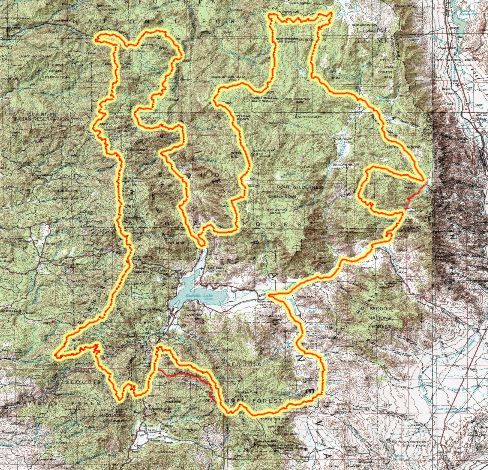 Note, this route isn't necessarily what I would publish as a final bikepacking loop. It is more to show what is possible up there and include as many good trails as possible. I optimized it for clockwise travel, but for a final published route I would shorten some parts to make it more rideable and make it fit into a 3-4 day timetable (for normal humans). I put this together from some of my own rides and from tracks that Erin posted. So I have not ridden all of it, mostly, it is the dirt road connections especially on the west side I have not been on. Some of those need to be scouted. There are a few additions I'd like to make that would also require scouting. I have ridden majority of the singletrack. Here's the route: Up Cannell. That's right. There is so much better out there than Cannell, so you might as well climb it. Do the route and find out! Up and over Sherman Peak, down to Schaeffer. Around various trails/roads up to Blackrock and over near Olancha, then down Jackass Creek and over to Kennedy Meadows. South on Chimney Peak road and down to Hwy 178. Across 178 and up Kelso Valley to Piute Mountain. Up to Lightner's Flat and down Mill Cr trail Cross river on Hwy 178 bridge, up Kern Canyon Tr and up Badger Gap North on Rancheria Rd, trails to Portuguese Pass, and various roads and trail segments. Up Summit Tr to Slate Mtn, down Bear Creek, up Camp Nelson Tr to Quaking Aspen. Down Freeman Cr, south on forest road to Johnsondale, down to Kern River and a ways up Sherman Pass Rd. Rincon Tr, down Packsaddle Tr, and south on Whiskey Flat Tr to Kernville. We could easily create a great loop on either side of the river and also have this full loop, and even have a separate loop for each direction of travel. There is so much opportunity here, the hard part can be deciding which option to take. If anyone knows how to work ridewithgps it would be cool to get this route posted so people can check the area out. |
|
|
|
|
Logged
|
|
|
|
|
Topic Name: Kern Plateau (Southern Sierras)
|
Reply #47 on: December 31, 2016, 02:34:26 PM
|
ec_duz_it
Location: Santa Barbara
Posts: 440
|
|
« Reply #47 on: December 31, 2016, 02:34:26 PM » |
|
Wow, this ride would be a beast! I can't really see much detail on the jpeg, if you want to send me the gpx file, ill see if i can get it to work in ridewithgps.
|
|
|
|
|
Logged
|
|
|
|
|
Topic Name: Kern Plateau (Southern Sierras)
|
Reply #48 on: January 01, 2017, 12:06:54 PM
|
evdog
Location: San Diego
Posts: 373
|
|
« Reply #48 on: January 01, 2017, 12:06:54 PM » |
|
Thanks, email sent!
|
|
|
|
|
Logged
|
|
|
|
|
Topic Name: Kern Plateau (Southern Sierras)
|
Reply #49 on: January 01, 2017, 03:45:34 PM
|
ec_duz_it
Location: Santa Barbara
Posts: 440
|
|
« Reply #49 on: January 01, 2017, 03:45:34 PM » |
|
Evan, I took your track, uploaded it to bikeroutetoaster.com, then re-downloaded the track from bikeroutetoaster. That seems to fix odd things with gpx files that ridewithgps doesn't like. https://ridewithgps.com/routes/18320659Here are a few thoughts I have on the mega loop. Starting point- I think Camp Nelson might be a better place to start. Good car camping there, a lodge, and a small store. Then you would start and end the ride with 2 great trails--start with Nelson Trail climb and end with Bear Creek descent). Or if you are driving from the east, Kennedy Meadows would be a good starting point. I wonder if there is a way to get from Lower Peppermint Campground to 32E29? I don't see anything on the map connecting Peppermint Falls trail and 32E29, but maybe there is a way. I don't know, I haven't explored that area. Then you could skip a good amount of pavement (this would also skip Johnsondale resupply, but maybe that would be ok if starting in Camp Nelson, and McNalleys Restaurant and Kernville would not be far away). I bikepacked Whiskey Flat to Packsaddle to Rincon in early April 2015. I rode in the northbound direction. The southbound direction you are proposing would be a much better direction than the way I rode it, but all 3 of those trails have some hard slow stuff in either direction. Those 3 trails together will take a lot longer to ride than it looks on the map. Overgrown trail, sandy conditions, etc. I don't think Rincon to Old Flume Trail would be any easier though, so I don't have any suggestions there. Going up Cannell Trail would be fine once you got to the top of the plunge. That is a 5,000 climb over 10 miles. This climb would be an ass kicker, but the trail is in good shape so it would be a doable hike. The Tenmile climb on the Colorado Trail is only a 3,600 climb over 8.5 miles and it was pretty much all walking for me. Beach Creek would probably be fine going uphill, but after riding up the Cannell Plunge, I think I would prefer riding up the fireroad. Going up Jackass Peak Trail would be hard. I think I would favor Granite Broder Trail over to Albinita Trail to get up to Jackass Peak. I rode Bitter Creek Trail in the downhill direction in early November of this year. It is a total sand pit. I rode it one week after a pretty good rainstorm and it still was sandy. You would need a fatbike to have any fun going down that trail. It is a shame because it is the only legal dirt option between Fish Creek Camp and Kennedy Meadows. Maybe that trail hardens up in the springtime after the snow melt? After that I haven't rode any of the stuff between Kennedy Meadows until the route reaches the Kern River again. I will say that Keyesville Trail to Kern Canyon Trail to Badger Gap was really amazing when I rode it. 30 miles or so of all nicely graded singletrack with very little HAB. But Mill Creek Trail looks like a ripping downhill too. I am tentatively thinking the weekend of May 26, 2017 to get out there and do a big ride. Hope we can meet up then! |
|
|
|
|
Logged
|
|
|
|
|
Topic Name: Kern Plateau (Southern Sierras)
|
Reply #50 on: January 01, 2017, 11:19:24 PM
|
evdog
Location: San Diego
Posts: 373
|
|
« Reply #50 on: January 01, 2017, 11:19:24 PM » |
|
Erin, thanks for correcting that file. It works for me now in Topofusion and Garminconnect. Interestingly, TF shows +/- 70k elevation vs +/-50k in ridewithgps! GC also shows +/-50k while NatGeo Topo shows +/-56k.
Good idea on starting somewhere other than Kernville, I hadn't considered that. If starting from Camp Nelson or Kennedy Meadows I would eliminate the start/end from Kernville entirely and go up Cedar Canyon via Rincon and Sherman Pass Rd instead. No Cannell or Just Outstanding on the route would make a lot of heads explode, which would be rather satisfying. Cedar Canyon has a 1k+ less gain than Cannell, still has lots of HAB opportunity, and is very remote and more interesting trail IMO. Best of all it would not have the 3-4 sucky HABs after climbing the plunge.
Another option if using Cedar Canyon would be to run the route CCW. Cedar Canyon is an awesome descent. Then, instead of up going Bear Creek, climb up the fire road south out of Coy Flat CG up to Windy Gap. It would miss some singletrack, but would be much more rideable than Bear Cr which would be 5k of mostly HAB going up. I have not been on that road, could be an interesting loop to check out.
It would be great if a connector existed from Lower Peppermint CG to the trail. Where the map shows private property, satellite shows a road down to a large camp or works yard there. The road is gated at Lloyd Meadows Rd. Maybe Caltrans? County? Not sure if it would be ok to pass through there, though you can see bits and pieces of trail nearby. Worst case you could go a little further and take the next trail connection down, or connect over from Elephant Knob and then down to the highway. Most of the trail 32E29 is visible on satellite from the middle connector. These are definitely options to check out. There is also a store / restaurant at Ponderosa near Quaking Aspen so missing Johnsondale resupply isn't a big deal.
I can't recall much of Beach except some sand. It may be better to go up road there, but if using the same route for both directions I would tend to route the trail on singletrack even if I'd prefer to be on road one direction unless it is completely heinous or no fun either direction. Its too bad Bitter Creek is sandy. Does it trend downhill enough that it is passable in that direction?
I have no problem creating a route for each direction, wouldn't be much more work. It may be the best way to optimize the route since there are so many tradeoffs for each direction.
Mill Creek is awesome, pretty buff and would probably be the funnest descent with loaded bike on the whole route. And it links almost perfectly to Kern Canyon. The tradeoff is the climb up to it is 3k up a paved road, just to descend right back down. And you miss a perfect resupply point in Isabella, unless you go off route. There is not much on that half of the route for resupply. We could cut out Mill Cr and then ride all of Kern Canyon instead. We could also cut out the Piutes entirely and ride straight over to Lake Isabella/Keyesville. But there is more exploring to do in the Piutes before making any decisions. If the singletrack I want to check out doesn't pan out then the Piutes will be all fire road. But there could be some really cool trail up there too.
I think the optimal way to go is have one massive route for people who want to be challenged, possibly a version for each direction, and then a few shorter routes. It is a huge area and there is definitely opportunity for multiple routes. Once we can check out a few remaining connections and unknown trails, it will be easy to put a number of routes together.
End of May is too far off for me to plan right now but Memorial Day is usually a good candidate for a Kernville Trip. There are at least a couple weekends worth of exploring still to do.
|
|
|
|
|
Logged
|
|
|
|
|
Topic Name: Kern Plateau (Southern Sierras)
|
Reply #51 on: January 01, 2017, 11:34:09 PM
|
evdog
Location: San Diego
Posts: 373
|
|
« Reply #51 on: January 01, 2017, 11:34:09 PM » |
|
A few other ideas to transform the big loop into something more manageable:
- cutting out Kernville and using Cedar Canyon I would also cut out Sherman Peak and just cut over on Schaeffer Tr to Beach
- as you mentioned there are easier ways to get to Jackass Peak/ Jackass Creek Tr. via Albinita/Granite Broder
- take shorter / direct route at Chimney Peak Rd
- cut out Bear Creek and Camp Nelson, drop down Summit Tr to Quaking Aspen instead (only if not starting route in Camp Nelson). I don't think Bear would be that much fun to bikepack down nevermind up.
A few other possible additions I'd like to check out:
- Clear Creek Tr down from Piutes. I did ride Badrock Tr over Labor Day, it would not be great for bikepacking. Clear Cr looks like a more steady descent.
- Woolstaff Meadow Tr from Kelso Valley Rd. I don't have a lot of hope for this, but who knows...
- route from Camp Nelson to the north and over to Jordan Peak lookout and Summit Tr
|
|
|
|
|
Logged
|
|
|
|
|
Topic Name: Kern Plateau (Southern Sierras)
|
Reply #52 on: January 02, 2017, 03:42:56 PM
|
ec_duz_it
Location: Santa Barbara
Posts: 440
|
|
« Reply #52 on: January 02, 2017, 03:42:56 PM » |
|
I agree with most of your suggestions. However, I would eliminate the northern section of summit trail (north of Quaking Aspen) from any route until it sees some serious maintenance. I rode it 2 months ago on the same trip as Bitter Creek. I would put it in the same category as lower Tobias Trail. It is totally overgrown and junky right now. I remember riding this trail about 6 years ago and it was quite fun. It looks like it just doesn't get enough use. The upper sections of summit trail were hard for us to even find.
I think either Nelson Trail or Bear Creek should be part of the route. Riding through the Giant Redwoods is truly special and should not be missed. Yes, these trails are technical, but so is a lot of the stuff in this area. This should be a mountain bikers route first and a bikepacking route second.
|
|
|
« Last Edit: January 02, 2017, 03:52:45 PM by ec_duz_it »
|
Logged
|
|
|
|
|
Topic Name: Kern Plateau (Southern Sierras)
|
Reply #53 on: January 07, 2017, 10:25:31 PM
|
evdog
Location: San Diego
Posts: 373
|
|
« Reply #53 on: January 07, 2017, 10:25:31 PM » |
|
Thanks. It has been a few years since I've done upper Summit. My friend is the one who maintain(ed) it. I have had trouble navigating it myself when it was in good shape when he was not with us. Haha, here is a TR from 2010, around the time you would have ridden it. http://dirttreaders.com/phpBB3/viewtopic.php?f=20&t=6512&hilit=summit. We did get lost on that ride. Summit has also suffered lots of deadfall that does not always get cut out. My friend has a new job as of a couple years ago that has limited his time to do trailwork. I had heard Stewards of Sequioa worked on Tobias lots last year so I'm surprised it is in bad shape. I rode it Memorial Day 2015 and it was ok. I think it can get overgrown quickly and is more of an adventure ride anyways. I wasn't considering it for bikepacking as I think it is too steep. I have always wanted to do a long ride from Alta Sierra to Tobias, and then return on Whiskey Flat. But that is a tough ride to time weather-wise. I do like the idea of Bear and Nelson being on the route. A bit of HAB never killed anyone. And you're right, the sequoia's on both trails are iconic. |
|
|
|
|
Logged
|
|
|
|
|
Topic Name: Kern Plateau (Southern Sierras)
|
Reply #54 on: January 09, 2017, 09:04:19 AM
|
ec_duz_it
Location: Santa Barbara
Posts: 440
|
|
« Reply #54 on: January 09, 2017, 09:04:19 AM » |
|
Summit Trail could be a great trail again if it sees some maintenance. It goes through some beautiful meadows. Even that switchback section right near Quaking Aspen was overgrown and bushy when we rode it this past November. Upper Tobias is fun right now (from Frog Meadow Campground to 23S16). Lower Tobias is the bad part (from 23S16 to Fairview Campground). The lower part has really poor drainage, some bushwacking, and overall it is unused and unmaintained. There are some really steep and sketchy downhill walk a bike sections. It is not fun or rideable in the downhill direction. The main problem I saw is that the trail has no waterbars to divert drainage off the trail. The drainage for the trail is the trail itself, so there are some really eroded deep ruts in the middle of the trail. It sounds like there is still some scouting to be done to confirm if this big loop will work. For this May, I think I will be doing the shorter point to point ride. I think that will be challenging enough. But I would love to come back as a separate trip to check out Mill Canyon, Remington Ridge, Clear Creek, etc. I wonder what the Kern River Mountain Bike Association would say about that area. I have asked them questions in the past via facebook and they have been helpful. www.facebook.com/KernRiverMountainBike/ |
|
|
|
|
Logged
|
|
|
|
|
Topic Name: Kern Plateau (Southern Sierras)
|
Reply #55 on: January 09, 2017, 10:50:05 AM
|
evdog
Location: San Diego
Posts: 373
|
|
« Reply #55 on: January 09, 2017, 10:50:05 AM » |
|
Mill and Remington are moto trails and get maintained by those users, which is why they are usually in good shape. A trail like Tobias is not motorized, and isn't well known to most so it sees little use and little mtce. It was rideable last year Memorial day, maybe it got hit hard by storms since then. Summit also sees little use, which is too bad since it is actually shuttleable. Not enough riders live in the area to maintain all the trails unfortunately.
|
|
|
|
|
Logged
|
|
|
|
|
Topic Name: Kern Plateau (Southern Sierras)
|
Reply #56 on: February 02, 2017, 08:25:50 AM
|
the tortoise
Posts: 472
|
|
« Reply #56 on: February 02, 2017, 08:25:50 AM » |
|
I do a lot with ridewithgps so if you have a gpx file to send me I can give it a go. my email is julianactive@sbcglobal.net |
|
|
|
|
Logged
|
|
|
|
|
Topic Name: Kern Plateau (Southern Sierras)
|
Reply #57 on: February 02, 2017, 08:28:10 AM
|
the tortoise
Posts: 472
|
|
« Reply #57 on: February 02, 2017, 08:28:10 AM » |
|
oooops I see it has already been done!
|
|
|
|
|
Logged
|
|
|
|
|
Topic Name: Kern Plateau (Southern Sierras)
|
Reply #58 on: June 09, 2017, 04:44:49 PM
|
ec_duz_it
Location: Santa Barbara
Posts: 440
|
|
« Reply #58 on: June 09, 2017, 04:44:49 PM » |
|
Trip report from last weekend... Tons of water in all the streams right now. 2-3 liters is all you need. Keysville / Kern Canyon / Badger Gap Trail are all riding nicely, but temps are a bit hot in that area. We rode evening and morning hours in that area and it was pretty nice. Plenty of water along all of those trails though. Rancheria Road is riding great and has been maintained recently. Unal Trail- Freaking awesome! No downed trees and trail is clear and clean. Portuguese Pass - Fireroad here is closed to vehicles, not sure if it is closed to bikes too. The whole area is pretty burnt. We stayed on the fireroad here. Portuguese Pass Trail is definitely closed right now due to the Cedar Fire last summer (there was red tape at the trailhead). Pup Meadow Trail - Needs some work, but it is fine. Just a lot of tree debris on the trail still from the winter. Fireroads west to Windy Gap (22S04 and other roads) - Excellent shape. Windy Gap to Slate Mountain Summit. Oh boy this was hard. The 1,000' walk a bike is not too bad after Windy Gap, the real ass kicker was the snow along the ridgeline before Slate Mountain. Some snow drifts were 6 to 9 feet high. I was the first person to summit Slate Mountain this year, and I can see why. 1 MPH moving speed getting through the snow drifts here. A good alternate might be Crawford Road (21S94) but that road does go through the Tule River Indian Reservation. Not sure if that section is open to the public. Bear Creek Trail - Needs a lot of work. A lot of snow at the top too. I would not recommend attempting this until Mid July, and even then, there will likely still be a lot of downed trees. The lower section gets fun though. This trail just needs some love. Camp Nelson- We made the restaurant by 7 pm. They close at 8 am. Good pizza and tacos. Nelson Trail - Excellent shape. The walk a bike back up to Quaking Aspen is not too bad. Such a beautiful trail. Upper Freeman Creek Trail- Freaking awesome!! Best trail of the trip! W Lower Freeman Creek Trail (after crossing Lloyd Meadows road) - hard to analyze this trail, since we got lost and ended up walking through the woods. I think you are supposed to cross the bridge at the private property. We thought that might be trespassing. Lloyd Meadows road - for pavement this is pretty nice. We rode it on a Monday and barely any cars. We tried to scout out forest road 22S53 (near Elephant Knob), but it was a bust. Private land owner is blocking access to 32E43. So I don't believe there is a way to bypass Johnsondale here and score more dirt. Johnsondale store was open when we were there and it was a great place to stop. It was a hot day and we needed a drink. We were going to go up Sherman Pass Road to Cherry Hill Road and then down lower Cannell Trail, but it was too late in the day and we had to get back to the car so we just hit the pavement back to Kernville. The third person in our group that cut the loop shorter did in fact ride this section and it looks like Big Meadow to Kernville is riding nice right now. I suspect there might be snow on upper Cannell like there was on Slate Mountain. You could see lots of white up in that direction from down below. I would not recommend going much higher than 8,000 feet right now. https://goo.gl/photos/uC4BvPDADdfhuPUH9 |
|
|
|
« Last Edit: June 09, 2017, 04:53:01 PM by ec_duz_it »
|
Logged
|
|
|
|
|
Topic Name: Kern Plateau (Southern Sierras)
|
Reply #59 on: August 08, 2018, 02:44:14 PM
|
cmonster_75
Posts: 4
|
|
« Reply #59 on: August 08, 2018, 02:44:14 PM » |
|
Hi guys, I've been planning on riding this area in a couple of weeks and I'm hoping for some feedback. My original plan was to do a big loop starting from Kernville- https://caltopo.com/m/TBPCI recently found out that the area around Portuguese Pass is closed including all roads north of Alta Sierra. According to the ranger station, the main road might open up next week. I've also realized that riding out of Kernville in 90-100 degree heat might not be the way I want to start my ride. I've since been focusing on starting from Kennedy Meadows and riding the plateau, here's the trails I've mapped out as options- https://caltopo.com/m/MKTPI'll have the Kern River Sierra map in the next couple of days and I have the trail descriptions the NF Kern Ranger District published. I'm planning on doing a clockwise loop starting with going down Mahogany-Cannell to Big Meadow, then up to Sherman Pass/Peak and north to Blackrock, etc. finishing with Jackass Creek; I'll have 4 days for this. There's quite a few options in the northern part of the loop, are there any recommendations? I'm a bit concerned about water, should I plan on hauling an extra 100 oz. or are there enough small streams along the way to get by with one water bladder? Any advice is appreciated, thanks! |
|
|
|
|
Logged
|
|
|
|
|
|


