 Topic Name: 2011 Tour Divide Topic Name: 2011 Tour Divide
|
Reply #1020 on: May 26, 2011, 06:32:11 PM
|
DaveH
Moderator
Posts: 975

|
 |
« Reply #1020 on: May 26, 2011, 06:32:11 PM » |
|
So I've been chipping away at getting Bluedot ready for Tour Divide. It's not quite ready, BUT I just added the snowpack overlays and it's too cool not to share. Caveats: - I haven't tested this on my phone, just a pc and turning everything on slows things down. It will probably choke a phone so go with caution.
- Also, it gets a bit crazy with the radar on as well - hard to tell where the colors are coming from when zoomed in.
- Finally, the event data is for last year. If you were on the roster last year and log into facebook from the app it will pick up your profile image and profile link.
- Chrome, Safari, Firefox, Android, iPhone, Blackberry all good as far as I know. NO IE
For now, it lives here (development version) http://bluedot.mobi/tl/tourdivide/tddev.phpThe app looks like this:  You can turn each layer on or off on the layers page (layer button on map) 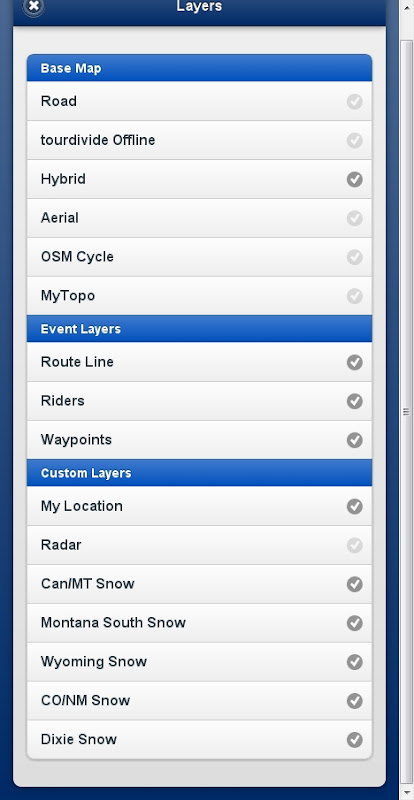 |
|
|
|
|
 Logged
|
|
|
|
|
Topic Name: 2011 Tour Divide
|
Reply #1021 on: May 26, 2011, 06:38:03 PM
|
krefs
Location: Prescott, AZ
Posts: 492
|
|
« Reply #1021 on: May 26, 2011, 06:38:03 PM » |
|
You haven't left your cave much in the past week have you Dave? Awesome work as always, though!
|
|
|
|
|
Logged
|
|
|
|
|
Topic Name: 2011 Tour Divide
|
Reply #1022 on: May 26, 2011, 09:10:40 PM
|
rfutah
Location: Herriman, Utah
Posts: 31
|
|
« Reply #1022 on: May 26, 2011, 09:10:40 PM » |
|
IN ALL SERIOUSNESS. I am from Florida and have no clue about snowshoes. Are snowshoes going to be a valuable kit component enough to offset their size and weight? I am running out of room on the bike to store anything else.
Thanks!
Jeff
Here in Utah this season, I have been using the Atlas racing snowshoes. They weigh about 2 lbs total. I have only hiked up to 2 miles at a time, while walking along side the bike (I think there is a lighter pair out there). I was going to take them on the TD, but have placed a request for a 7/8 ITT. Hopefully I wont need them in July. |
|
|
|
|
Logged
|
|
|
|
|
Topic Name: 2011 Tour Divide
|
Reply #1023 on: May 27, 2011, 07:45:57 AM
|
ridingman1
Drinkin' upstream from the herd
Location: Spartanburg, SC
Posts: 75

|
|
« Reply #1023 on: May 27, 2011, 07:45:57 AM » |
|
|
|
|
|
|
Logged
|
|
|
|
|
Topic Name: 2011 Tour Divide
|
Reply #1024 on: May 27, 2011, 08:00:41 AM
|
trebor
Location: Los Angeles, CA
Posts: 375
|
|
« Reply #1024 on: May 27, 2011, 08:00:41 AM » |
|
yea! more snow this weekend and 70's by the end of the week... cutting it SSOOO close......
|
|
|
|
|
Logged
|
Rob Roberts
|
|
|
|
Topic Name: 2011 Tour Divide
|
Reply #1025 on: May 27, 2011, 08:09:28 AM
|
elitheknife
Posts: 60
|
|
« Reply #1025 on: May 27, 2011, 08:09:28 AM » |
|
Snowing in Banff this morning...
|
|
|
|
|
Logged
|
|
|
|
|
Topic Name: 2011 Tour Divide
|
Reply #1026 on: May 27, 2011, 09:16:32 AM
|
annoying crack
Location: brussels
Posts: 127
|
|
« Reply #1026 on: May 27, 2011, 09:16:32 AM » |
|
Hi all, I'm finally taking the time (found the courage) to make cues and study the route a bit more. But I'm getting confused!! I really do NOT want to take the wrong route but it's not all that clear to me. I found the following on the Tourdivide.org website: Challengers must always ride 100% of the 'main' ACA Great Divide Route as defined by the most current edition of the ACA maps. Previous map editions may not be used unless updated with the most current ACA Addenda.
Alternates: At times along the GDMBR, ACA maps provide cues for 'Alternate Routes'. No ACA Alternates to the main route may be used with the exception of the following THREE in NM.
a.The 116-mile section between Cuba and Grants, New Mexico. The main route is impassable, potentially dangerous when wet, so racers have the option to follow the alternate paved route.
b.The 40-mile section between Grants and the Pie Town road, through El Malpais National Monument. Zuni Canyon (main route south of Grants) is commonly closed for fire danger.
c.The ~12-mile section of Continental Divide NST between Sapillo Campground on NM Hwy 35 and NM 15 (just North of Pinos Altos / Silver City)
Alternates Notes: A & B are optional for TD challengers, however both are paved/faster, have evolved as the standard route for 'records-seekers'. Alternate C is new for the 2011 printing of Map 6 and the required TD race route.So I understand that I follow all the main route everywhere except: a. Chaco Alternate on map 5B (optional but really the route that is followed by everyone?) b. El Malpais Alternate on map 5B (optional but really the route that is followed by everyone?) c. C.D.T. Alternate on map 6A (required) Do I understand that all right? Those are the only alternates and the rest is the main route! That's also what the official GPS track follows, right? Then, what is that Golddust trail that I read about? Where do I find that one? Why is it's not mentioned in the rules but is it mentioned by Scott M. in the GPS-file thread? Or has that been added to the new maps and I'll just follow the main route on it? If so, what map do I find it on? Can anyone please clear this out for me because it's all a bit confusing to me.  I know, I'm a bit slow so sorry about that. I'm not even thinking about the snow detours... |
|
|
|
« Last Edit: May 27, 2011, 09:22:48 AM by annoying crack »
|
Logged
|
|
|
|
|
Topic Name: 2011 Tour Divide
|
Reply #1027 on: May 27, 2011, 09:33:32 AM
|
krefs
Location: Prescott, AZ
Posts: 492
|
|
« Reply #1027 on: May 27, 2011, 09:33:32 AM » |
|
So I understand that I follow all the main route everywhere except:
a. Chaco Alternate on map 5B (optional but really the route that is followed by everyone?)
b. El Malpais Alternate on map 5B (optional but really the route that is followed by everyone?)
c. C.D.T. Alternate on map 6A (required)
Correct, correct, and correct. The Gold Dust trail is a non-GDMBR section TD is adding this year on the descent from Boreas Pass (above Breckenridge, CO) into South Park. It's on the GPX track, and from what's been mentioned here previously, there will be some approximate cues for this trail. It's only a few miles long, but it's steep enough that NoBo riders will be allowed to follow the dirt road climb, and only SoBo riders will be required to ride the Gold Dust Trail down...that is unless it's still covered by deep snow? |
|
|
|
|
Logged
|
|
|
|
|
Topic Name: 2011 Tour Divide
|
Reply #1028 on: May 27, 2011, 10:22:21 AM
|
annoying crack
Location: brussels
Posts: 127
|
|
« Reply #1028 on: May 27, 2011, 10:22:21 AM » |
|
Correct, correct, and correct. The Gold Dust trail is a non-GDMBR section TD is adding this year on the descent from Boreas Pass (above Breckenridge, CO) into South Park. It's on the GPX track, and from what's been mentioned here previously, there will be some approximate cues for this trail. It's only a few miles long, but it's steep enough that NoBo riders will be allowed to follow the dirt road climb, and only SoBo riders will be required to ride the Gold Dust Trail down...that is unless it's still covered by deep snow?
Thanks Kurt! So, Gold dust trail is between Boreas pass and Como then? East or west of the ACA-trail? I'll draw it up on my map so I have some sort of memory when I look on the maps later. Excuse my ignorance but I live half a planet away... and google is not always my friend.  |
|
|
|
|
Logged
|
|
|
|
|
Topic Name: 2011 Tour Divide
|
Reply #1029 on: May 27, 2011, 11:11:33 AM
|
6thElement
Posts: 234
|
|
« Reply #1029 on: May 27, 2011, 11:11:33 AM » |
|
Gold Dust to the West, ACA route to the East.  |
|
|
|
|
Logged
|
|
|
|
|
Topic Name: 2011 Tour Divide
|
Reply #1030 on: May 27, 2011, 11:44:46 AM
|
annoying crack
Location: brussels
Posts: 127
|
|
« Reply #1030 on: May 27, 2011, 11:44:46 AM » |
|
Gold Dust to the West, ACA route to the East.
Awesome! I can't thank everybody here enough. |
|
|
|
|
Logged
|
|
|
|
|
Topic Name: 2011 Tour Divide
|
Reply #1031 on: May 27, 2011, 12:23:35 PM
|
Area45
Posts: 59
|
|
« Reply #1031 on: May 27, 2011, 12:23:35 PM » |
|
Question about traveling. I'm planning to pack most of my gear in the box with the bike. Can I put things like chain lube or snacks in the box? As long as it's not aerosol it should be ok right? Anything I should avoid putting in the bike box?
|
|
|
|
|
Logged
|
|
|
|
|
Topic Name: 2011 Tour Divide
|
Reply #1032 on: May 27, 2011, 12:30:41 PM
|
mcmurv
Location: Austin, TX
Posts: 85
|
|
« Reply #1032 on: May 27, 2011, 12:30:41 PM » |
|
Awesome! I can't thank everybody here enough.
Crack man: Yea, you will love the Gold Dust Trail. As you start to follow the road down out of Boreas Pass, there is a trail about 300 yards / 274 meters on the right. It is easy to miss. If you ride on the right side of the road as you come across the top of Boreas Pass, you will see the trail going into the woods in the distance. Be ready to take off like a rocket when you pull off the road. She WILL get your heart going more than the climb up Boreas Pass! As you can tell, it is one of my all time favorite trails outside of Monarch. |
|
|
|
|
Logged
|
|
|
|
|
Topic Name: 2011 Tour Divide
|
Reply #1033 on: May 27, 2011, 12:32:25 PM
|
mcmurv
Location: Austin, TX
Posts: 85
|
|
« Reply #1033 on: May 27, 2011, 12:32:25 PM » |
|
Question about traveling. I'm planning to pack most of my gear in the box with the bike. Can I put things like chain lube or snacks in the box? As long as it's not aerosol it should be ok right? Anything I should avoid putting in the bike box?
Not really. I would recommend to watch the weight of the box. On most airlines, if you bust 50 lbs or 72 lbs, you will incur some more charges. That way it might be better to split it up in a fold-able bag to be mailed home or thrown away. |
|
|
|
|
Logged
|
|
|
|
|
Topic Name: 2011 Tour Divide
|
Reply #1034 on: May 29, 2011, 06:54:55 AM
|
JayP
Posts: 130
|
|
« Reply #1034 on: May 29, 2011, 06:54:55 AM » |
|
as i sit here watching it dumping snow in victor, id. i am thinking you all are going to have a most excellent epic trip this year. one just needs to plan a little differently, with gear, time, and most importantly your mental state IF you want to follow the route. and if you decide not to, which is fine too, you will be having a blast trying to figure out the most intresting route to get through the sections YOU choose to go around and there is plenty of good country to do that with. a lot will be discovered by doing this espically with everyone possibly doing something different.
have fun out there guys and gals...
|
|
|
|
|
Logged
|
|
|
|
|
Topic Name: 2011 Tour Divide
|
Reply #1035 on: May 29, 2011, 07:06:00 AM
|
BobM
Location: The Keweenaw Peninsula, Michigan
Posts: 936
|
|
« Reply #1035 on: May 29, 2011, 07:06:00 AM » |
|
as i sit here watching it dumping snow in victor, id. i am thinking you all are going to have a most excellent epic trip this year. one just needs to plan a little differently, with gear, time, and most importantly your mental state IF you want to follow the route. and if you decide not to, which is fine too, you will be having a blast trying to figure out the most intresting route to get through the sections YOU choose to go around and there is plenty of good country to do that with. a lot will be discovered by doing this espically with everyone possibly doing something different.
have fun out there guys and gals...
As usual, Jay's got it about right IMO. Don't sweat the TourDivide, the Historical GC, the Annual GC. Maybe your adventure will not be "official" according to TourDivide rules, but it will still be YOUR adventure. If you're really concerned about those things, do as some are doing and switch to an ITT a bit later in the year. |
|
|
|
|
Logged
|
|
|
|
|
Topic Name: 2011 Tour Divide
|
Reply #1036 on: May 29, 2011, 01:52:59 PM
|
6thElement
Posts: 234
|
|
« Reply #1036 on: May 29, 2011, 01:52:59 PM » |
|
Getting the time off work was tough so I can't rearrange, I've got the flights booked so that's pretty much what I'd decided upon this past week. I'm going to race my Divide course and still hopefully make it to the Mexican border.
|
|
|
|
|
Logged
|
|
|
|
|
Topic Name: 2011 Tour Divide
|
Reply #1037 on: May 29, 2011, 06:46:04 PM
|
Nathan Jones
Posts: 129
|
|
« Reply #1037 on: May 29, 2011, 06:46:04 PM » |
|
Anyone want to weigh in with a rumor on possible re-routes besides the fernie alt? From the snow sat estimates I'd say we are looking at multiple alt's but maybe I'm just reading it wrong. I live in Oregon and looking at what's on the divide versus the cascades and I'd say it's mostly FUBAR. Perhaps that is just the pessimist in me!
|
|
|
|
|
Logged
|
|
|
|
|
Topic Name: 2011 Tour Divide
|
Reply #1038 on: May 30, 2011, 02:50:31 AM
|
Blackhound
Location: Derby, UK
Posts: 126
|
|
« Reply #1038 on: May 30, 2011, 02:50:31 AM » |
|
My flights were booked some time ago so can't change very much. I leave Seattle on 2nd August so could delay a couple of weeks but don't think conditions will change all that much in 2/3 weeks.
My focus will be first of all be on getting home safely and then enjoying myself out on the trail - I expect some pain and wondering what the hell I am doing out there though! I will look at alternatives if conditions dictate - the TD will be there in future, and I want to be around to do it.
It is going to be an adventure whatever happens so bring it on.
|
|
|
|
|
Logged
|
|
|
|
|
Topic Name: 2011 Tour Divide
|
Reply #1039 on: May 30, 2011, 06:45:46 AM
|
Slowerthensnot
Have fun and go far
Location: Idledale, CO
Posts: 396
|
|
« Reply #1039 on: May 30, 2011, 06:45:46 AM » |
|
fernie detourhttp://maps.google.com/maps?f=d&source=s_d&saddr=Fernie,+BC,+Canada&daddr=49.1119421,-115.149286+to:49.07316,-115.13342+to:48.953567,-115.0852221+to:48.90521,-115.07705+to:Eureka,+MT&hl=en&geocode=Fadf8wIdBkgk-Skv-jy7jmtlUzFnoXlNlGnI7Q%3BFYZj7QIdGvYi-SkFk1hI765lUzE5_TUvpS9cQQ%3BFQjM7AIdFDQj-SlH4Hv9aq5lUzElG2qnCz6Fzw%3BFd_46gIdWvAj-SnR2Ml-QLRlUzEeqBHVw-iQ8w%3BFfo76gIdRhAk-Sm7SFeQebVlUzEYvctGUn2FfA%3BFULL6QIdLmsk-Sl5XofPX8plUzHwgJ3vnsywwQ&gl=us&mra=dpe&mrsp=2&sz=12&via=1,2,3,4&sll=49.071392,-115.137405&sspn=0.123929,0.220757&ie=UTF8&z=12
around red feather and whitefish divide
http://maps.google.com/maps?f=d&source=s_d&saddr=Eureka,+MT&daddr=48.82949,-114.99291+to:48.72332,-114.83666+to:48.661965,-114.748865+to:48.5002091,-114.5331388+to:48.48771,-114.42301+to:Whitefish,+MT&hl=en&geocode=FULL6QIdLmsk-Sl5XofPX8plUzHwgJ3vnsywwQ%3BFTIU6QId8lgl-SmVLQBif8xlUzGpuJ_Lk1WW6g%3BFXh15wIdTLsn-SndhUIS2tNlUzH9q9KBOmpgng%3BFc2F5gIdPxIp-Sn_hTYsZNZlUzFS2FtCcbVpHA%3BFfEN5AId7lws-SnNQIKwMGVmUzF2sDDa0VfBVQ%3BFR7d4wIdHgsu-SlFu7J4B29mUzFJtSPcpWHdpw%3BFcSx4gIdn1gv-Sm17K8Uq2lmUzE-RjeIa3rKzA&gl=us&mra=dpe&mrsp=5&sz=12&via=1,2,3,4,5&sll=48.451976,-114.428787&sspn=0.125467,0.220757&ie=UTF8&z=12around Richmond peakhttp://maps.google.com/maps?f=d&source=s_d&saddr=Seely+Lake,+MT&daddr=MT-83+N&hl=en&geocode=FXTmzwIdFV08-SlxR-YQpAtdUzEtRLqU5ot8Fg%3BFRo40wId-v85-Q&gl=us&mra=dme&mrsp=1&sz=9&sll=47.55817,-113.673575&sspn=1.02127,1.766052&ie=UTF8&z=9Just some ideas, take em with a gain of salt, I haven't ridden any other then from whitefish to eureka in 2006 riding my butt to the start of the GDR..And i rode though Fernie as that was the only route in 2008.. but these are some ideas around the worst of it, maybe someone should post about WY
|
|
|
|
|
Logged
|
|
|
|
|
|


