Topic Name: Routes For Pisgah Nat Forest in North Carolina? Topic Name: Routes For Pisgah Nat Forest in North Carolina?
|
on: March 19, 2011, 06:08:40 PM
|
stumpbumper
Posts: 38

|
 |
« on: March 19, 2011, 06:08:40 PM » |
|
Any recommendations on bikepacking routes in the Pisgah National Forest of North Carolina? Some of the trails there are extremely difficult even for advanced mountain bikers to ride and they are not hauling gear. What I am looking for is a mildly-strenuous three or four day route with plenty of nice scenery. I know mountain bikers who ride there a lot but they are not into bikepacking so cannot relate. I have ridden the Bent Creek area but from what I saw, it is not large enough for a multiple-day trip. If someone has one or more point-to-point recommendations I can round up a map and go from there. Thanks.  |
|
|
|
|
 Logged
|
|
|
|
|
Topic Name: Routes For Pisgah Nat Forest in North Carolina?
|
Reply #1 on: March 20, 2011, 07:06:28 AM
|
jhl99
USA-PA-SW
Posts: 256
|
|
« Reply #1 on: March 20, 2011, 07:06:28 AM » |
|
There was an article in Bike Magazine a few years ago... A couple of weekend warriors did a multi-day ride. I want to say they road from Bent Creek to DuPont, they cached food and beer along the way. Can't remember all the details, but the riding wiped them out.
It seems like there are many hardcore riders in that area, one would think there has been more overnight/multi-night mountain biking--it just isn't published or reported.
One thing is for sure, being choosy on the route/road/trail taken to climb those mountains would be worthwhile.
I've been to Pisgah a couple of times, I think that "Mildly strenous" and multi-day may be mutually exclusive, but maybe someone with deeper local knowledge would be better to comment.
|
|
|
|
« Last Edit: March 20, 2011, 07:09:58 AM by jhl99 »
|
Logged
|
|
|
|
|
Topic Name: Routes For Pisgah Nat Forest in North Carolina?
|
Reply #2 on: March 20, 2011, 04:07:20 PM
|
Emily
Location: Asheville
Posts: 49

|
|
« Reply #2 on: March 20, 2011, 04:07:20 PM » |
|
Any recommendations on bikepacking routes in the Pisgah National Forest of North Carolina? Some of the trails there are extremely difficult even for advanced mountain bikers to ride and they are not hauling gear.
What I am looking for is a mildly-strenuous three or four day route with plenty of nice scenery. I know mountain bikers who ride there a lot but they are not into bikepacking so cannot relate. I have ridden the Bent Creek area but from what I saw, it is not large enough for a multiple-day trip.
If someone has one or more point-to-point recommendations I can round up a map and go from there.
It is easy to link trails together to go across the Pisgah Ranger District in a nice point-to-point. There are several ways to do this, I have done it a couple different routes and there is no wrong answer. My recommended route would link many trails together, part of the problem is just that I forget the name of some of the forest service roads involved. In essence it would be Bent Creek trails-Bent Creek Gap rd-5000B-Spencer Gap-Trace Ridge-??-1206-Laurel Mtn-Pilot-??-Horse Cove-Squirrel Gap-South Mills-Buckhorn-Black Mountain-Buckwheat-Bennett-Coontree-475-5003?-105?-Farlow-Daniels Ridge-225-Cove Creek. Easy to take off the Farlow part. You end up a couple miles from the town of Brevard. Hopefully one of the other Pisgah riders who post on here will chime in too. I am sure Mike B knows the names of all the gravel roads. Some trails are way more fun in one direction than the other, and some are closed seasonally. Get National Geographic map 780 "Pisgah Ranger District" for planning. Also there was this http://adventuresinpisgah.blogspot.com/2009/11/pisgah-99.html which seemed like a one-day route but was so hard only one of us finished. It might be pretty fun as a two or three day route though. It would also possible to use the Blue Ridge Parkway to link the Grandfather Ranger District to the Pisgah Ranger District or ride county roads from Pisgah to Dupont. Nothing in Pisgah proper is as flat and groomed as Bent Creek. I do not think a ride on those trails could accurately depict to you what Pisgah is like. Many who don't have much experience in Pisgah fall into the trap of over-estimating how much ground can be covered in a day. Trails are steep and often rocky--4 or 5 miles per hour is about as much as most can expect for a sustained pace. If you are not familiar with the trails, even slower. Something that involves one or two loops (and hence potential bail-out options), rather than a committing point-to-point, might be a good option to consider. Have fun!! |
|
|
|
« Last Edit: March 20, 2011, 04:29:23 PM by Emily »
|
Logged
|
|
|
|
|
Topic Name: Routes For Pisgah Nat Forest in North Carolina?
|
Reply #3 on: March 21, 2011, 07:05:18 AM
|
trebor
Location: Los Angeles, CA
Posts: 375
|
|
« Reply #3 on: March 21, 2011, 07:05:18 AM » |
|
Pisgah for bikepacking is tough (on the body).
using lots of singletrack to make a route with a loaded bike just makes me ache. That said, several of us are heading up on the next to last weekend in April for just that. Just a 2 night adventure (suffer-fest).
We will use a lot of forest service roads and keep the ST to a minimum. We are really going for the climbing and the remoteness.
|
|
|
|
|
Logged
|
Rob Roberts
|
|
|
|
Topic Name: Routes For Pisgah Nat Forest in North Carolina?
|
Reply #4 on: March 21, 2011, 10:47:45 AM
|
6thElement
Posts: 234
|
|
« Reply #4 on: March 21, 2011, 10:47:45 AM » |
|
/jealous of Trebors trip.
|
|
|
|
|
Logged
|
|
|
|
|
Topic Name: Routes For Pisgah Nat Forest in North Carolina?
|
Reply #5 on: March 21, 2011, 06:14:04 PM
|
stumpbumper
Posts: 38
|
|
« Reply #5 on: March 21, 2011, 06:14:04 PM » |
|
Pisgah for bikepacking is tough (on the body).
using lots of singletrack to make a route with a loaded bike just makes me ache. That said, several of us are heading up on the next to last weekend in April for just that. Just a 2 night adventure (suffer-fest).
We will use a lot of forest service roads and keep the ST to a minimum. We are really going for the climbing and the remoteness.
If you come up with a route using mostly service roads and minimum ST, I would appreciate you sharing it as I will give it a go. On the same weekend you are at Pisgah several friends and I will be bikepacking the Lake Moultrie/Swamp Fox/Awendaw passages (74 miles) of the Palmetto Trail in SC. You can bet our trip will be much kinder to the body than yours. |
|
|
|
|
Logged
|
|
|
|
|
Topic Name: Routes For Pisgah Nat Forest in North Carolina?
|
Reply #6 on: March 22, 2011, 05:34:03 AM
|
trebor
Location: Los Angeles, CA
Posts: 375
|
|
« Reply #6 on: March 22, 2011, 05:34:03 AM » |
|
If you come up with a route using mostly service roads and minimum ST, I would appreciate you sharing it as I will give it a go. On the same weekend you are at Pisgah several friends and I will be bikepacking the Lake Moultrie/Swamp Fox/Awendaw passages (74 miles) of the Palmetto Trail in SC. You can bet our trip will be much kinder to the body than yours.
At this point I have left the route-making up to the two other folks going on the trip. One has been in contact with Eric from Pisgah Productoins to get some recommendations too - I'm not sure if that is a good idea or not...........  We'll see. If a route is finalized prior to departure, I'll post it. After we are done I'll have a gpx if anyone would care for it. |
|
|
|
|
Logged
|
Rob Roberts
|
|
|
|
Topic Name: Routes For Pisgah Nat Forest in North Carolina?
|
Reply #7 on: March 22, 2011, 05:38:31 AM
|
trebor
Location: Los Angeles, CA
Posts: 375
|
|
« Reply #7 on: March 22, 2011, 05:38:31 AM » |
|
I also HIGHLY recommend using the Trans North Georgia Adventure route for bikepacking. The first 100+ miles is fire road climbing and the latter half is mostly singletrack. Just another option for those on the south-east coast. http://www.firstworks.com/tnga/ |
|
|
|
|
Logged
|
Rob Roberts
|
|
|
|
Topic Name: Routes For Pisgah Nat Forest in North Carolina?
|
Reply #8 on: March 22, 2011, 05:17:04 PM
|
jhl99
USA-PA-SW
Posts: 256
|
|
« Reply #8 on: March 22, 2011, 05:17:04 PM » |
|
I took a look and found the issue of Bike. Sept/Oct 2008. The issue is appropriately titled "Why the East Coast Rocks"
The basic plan of their route was Bent Creek..Mills River..Davidison River.. Dupont. 3 days, 90 miles. The author makes it sound like they are casual riders. From the photos, it looks like they carried all their gear in backpacks...and paid a price for that.
A good quote: "We are broken. We are demoralized..." but they made it. They bailed on some singletrack in Pisgah, but eventually topped out on the top Cedar Rock in Dupont.
****
I'm not sure if the area is big enough for a multi-day ride, but I really liked the Wilson Creek area.
|
|
|
|
|
Logged
|
|
|
|
|
Topic Name: Routes For Pisgah Nat Forest in North Carolina?
|
Reply #9 on: March 23, 2011, 04:15:59 PM
|
Mike Brown
Posts: 93
|
|
« Reply #9 on: March 23, 2011, 04:15:59 PM » |
|
stumpbumper- tie Wilson's and Pisgah District gravel together with a Parkway stint and you have an awesome trip.
Pisgah District trails and roads can combine for great 1-3 night options. Routes are endless. Emily's above is hard. Four of the trails are uber tech high speed rocky descents- I've done them all on loaded bikes, but would not recommend it for an inexperienced bikepacker or if you don't list tech skills at the top of your riding strengths. I'd take 2 nights/ 3 days (with days 1 or 3 being short) riding to do it. 3 nights could be had by riding a different, easier route back to Asheville. I can recommend easier routes overall. What kind of ride are you looking for?
|
|
|
|
|
Logged
|
|
|
|
|
Topic Name: Routes For Pisgah Nat Forest in North Carolina?
|
Reply #10 on: March 23, 2011, 06:14:53 PM
|
stumpbumper
Posts: 38
|
|
« Reply #10 on: March 23, 2011, 06:14:53 PM » |
|
I took a look and found the issue of Bike. Sept/Oct 2008. The issue is appropriately titled "Why the East Coast Rocks"
The basic plan of their route was Bent Creek..Mills River..Davidison River.. Dupont. 3 days, 90 miles. The author makes it sound like they are casual riders. From the photos, it looks like they carried all their gear in backpacks...and paid a price for that.
A good quote: "We are broken. We are demoralized..." but they made it. They bailed on some singletrack in Pisgah, but eventually topped out on the top Cedar Rock in Dupont.
****
I'm not sure if the area is big enough for a multi-day ride, but I really liked the Wilson Creek area.
I appreciate you going to the trouble of digging up that issue of Bike mag. I also have it and the article you refer to is appropriately titled "Pushing Pisgah". I don't recall reading the article and will do so later this afternoon. I'll take a look at the Wilson Creek area as well. |
|
|
|
|
Logged
|
|
|
|
|
Topic Name: Routes For Pisgah Nat Forest in North Carolina?
|
Reply #11 on: March 23, 2011, 06:36:40 PM
|
stumpbumper
Posts: 38
|
|
« Reply #11 on: March 23, 2011, 06:36:40 PM » |
|
stumpbumper- tie Wilson's and Pisgah District gravel together with a Parkway stint and you have an awesome trip.
Pisgah District trails and roads can combine for great 1-3 night options. Routes are endless. Emily's above is hard. Four of the trails are uber tech high speed rocky descents- I've done them all on loaded bikes, but would not recommend it for an inexperienced bikepacker or if you don't list tech skills at the top of your riding strengths. I'd take 2 nights/ 3 days (with days 1 or 3 being short) riding to do it. 3 nights could be had by riding a different, easier route back to Asheville. I can recommend easier routes overall. What kind of ride are you looking for?
I may be looking for something that's unavailable in Pisgah but I would like to come up with a route most of which can be ridden by an intermediate-level mountain biker hauling 30 pounds or so of food and gear. I don't mind pushing when I have to but I'd rather ride more and push less if possible. Single-track is nice but if I have to ride mostly service roads to get through more scenic country that's what I would choose. A loop is preferred but I have a MTB buddy who will likely accompany me so we could handle a one-way trip by dropping off a car at the other end. Distance would depend on the degree of difficulty and since I have not bikepacked Pisgah I don't have a feel for the number of miles per day I can comfortably handle there. If we were talking DuPont I would probably say 15-20 miles per day with bikepacking gear. In April we are bikepacking the Lake Moultrie, Swamp Fox and Awendaw passages of the PT in SC and I figure we will average 20-30 miles per day but that's flat country and nothing like Pisgah. |
|
|
|
« Last Edit: March 23, 2011, 06:56:14 PM by stumpbumper »
|
Logged
|
|
|
|
|
Topic Name: Routes For Pisgah Nat Forest in North Carolina?
|
Reply #12 on: March 23, 2011, 07:00:51 PM
|
stumpbumper
Posts: 38
|
|
« Reply #12 on: March 23, 2011, 07:00:51 PM » |
|
I tried to add this to my previous reply via "Edit" but didn't work.
I am a pokey rider rather than one who tries to ride as fast and as far as possible each day. I often use up a lot of time shooting photos and just pausing to enjoy the sights.
|
|
|
|
|
Logged
|
|
|
|
|
Topic Name: Routes For Pisgah Nat Forest in North Carolina?
|
Reply #13 on: March 31, 2011, 11:43:21 AM
|
Chunt
Location: Atlanta, Ga
Posts: 75
|
|
« Reply #13 on: March 31, 2011, 11:43:21 AM » |
|
I tried to add this to my previous reply via "Edit" but didn't work.
I am a pokey rider rather than one who tries to ride as fast and as far as possible each day. I often use up a lot of time shooting photos and just pausing to enjoy the sights.
I'd say you're approaching it right. If you're carrying your gear on a bike, primitive camping, enjoying yourself and seeing things you never saw before, you're bikepacking. I backpacked for years and the idea of carrying it on a bike and being able to coast down hills is so cool I was attracted immediately. |
|
|
|
|
Logged
|
Before you judge a man, try walking a mile in his shoes. That way when you do judge him you'll be a mile away and have his shoes.
|
|
|
|
Topic Name: Routes For Pisgah Nat Forest in North Carolina?
|
Reply #14 on: March 31, 2011, 12:40:41 PM
|
jhl99
USA-PA-SW
Posts: 256
|
|
« Reply #14 on: March 31, 2011, 12:40:41 PM » |
|
I just stumbled accross a bunch of info I compiled for a group trip to Pisgah. The info was compiled for a '2009 Forum Ride' for members from the Dirt Rag Magazine forum. ... the trip never happened (although trips is 2007 and 2008 where successes). The trip was to be car camping+riding, but the info still might be of some value for a bike touring trip. http://home.windstream.net/JHLange/TheRide09.htmlThere is a link in there http://home.windstream.net/JHLange/PNF_OverviewMap.pdf that shows and overview of the lay of the land. There are also links to some pics. A sample: 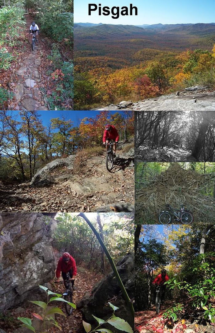 |
|
|
|
« Last Edit: March 31, 2011, 12:51:00 PM by jhl99 »
|
Logged
|
|
|
|
|
Topic Name: Routes For Pisgah Nat Forest in North Carolina?
|
Reply #15 on: April 04, 2011, 12:48:30 PM
|
stumpbumper
Posts: 38
|
|
« Reply #15 on: April 04, 2011, 12:48:30 PM » |
|
My thanks to everyone for the information. |
|
|
|
|
Logged
|
|
|
|
|
Topic Name: Routes For Pisgah Nat Forest in North Carolina?
|
Reply #16 on: April 05, 2011, 05:44:40 PM
|
Mike Brown
Posts: 93
|
|
« Reply #16 on: April 05, 2011, 05:44:40 PM » |
|
sb- I have about 1/2 of a sweet detailed route description written out for you. I'll post it here when done, and probably add it to the routes stuff in the header. I've got some time on my hands (injured), so I'm probably going to write up 3 or so Pisgah 2-3 day bikepacking routes of varying challenge and contribute to the site.
|
|
|
|
|
Logged
|
|
|
|
|
Topic Name: Routes For Pisgah Nat Forest in North Carolina?
|
Reply #17 on: April 06, 2011, 11:00:13 AM
|
sherpaxc
Location: Austin, TX
Posts: 577
|
|
« Reply #17 on: April 06, 2011, 11:00:13 AM » |
|
Mike Brown you are the greatest thing since peanut butter cups. Post it cause I want to make it out there again! Went last year and spent 3 days riding (base camp in Brevard) and had all kinds of good times.
|
|
|
|
|
Logged
|
|
|
|
|
Topic Name: Routes For Pisgah Nat Forest in North Carolina?
|
Reply #18 on: April 25, 2011, 08:38:04 AM
|
trebor
Location: Los Angeles, CA
Posts: 375
|
|
« Reply #18 on: April 25, 2011, 08:38:04 AM » |
|
Here is a quick break down of our trip. Very doable fully loaded.
Parked at Walmart in Pisgah Forest/Brevard. Headed south to Dupont Forest on Everret Rd to Crab Creek to Dupont Rd. Hit up some single and double track for about 25 miles or so (with good route selection this is all doable fully loaded - We both had full TD kits on the bikes). Leave Dupont via Tower Road/Rock Quarry Rd (doubletrack) up to Rich Mtn Rd (which eventually turns to pavement and one-HELL-of-a SCREAMING downhill!!!!) to 276 to Wilson Rd. Back in Brevard stop at car for a couple of items and a meal. Head all the way up 276 to the Blue Ridge Parkway. East on BRP - tried to drop in on "Little Pisgah Ridge" but that was far too gnarly for bikepacking. Backed up to the BRP and continued east to Bent Creek. Hit up some of the easy singletrack down to and through the Arboritum. Back on BRP over to Liberty Bikes and food on Hwy 25. Continued up BRP toward Mt Mitchell area. We "stealth" bivied when the sun went down.... but you can continue for more miles by using some of the roads near Old Fort and Black Mountain like Curtis Creek and FR472. We returned at sun-up to South Asheville for food and then back over to Bent Creek via BRP and up the doubletrack (South Ridge Rd, I think) to FR 5000. Down 5000 to North Mills River campground then pick up FR1206 all the way across to 276 and downhill back to the car.
Our route was about 150 miles and all easy to ride fully loaded - though some of the grades here and there are pretty steep.
|
|
|
|
|
Logged
|
Rob Roberts
|
|
|
|
Topic Name: Routes For Pisgah Nat Forest in North Carolina?
|
Reply #19 on: April 25, 2011, 12:10:01 PM
|
sherpaxc
Location: Austin, TX
Posts: 577
|
|
« Reply #19 on: April 25, 2011, 12:10:01 PM » |
|
Dude, ya'll missed all the fun singletrack!
|
|
|
|
|
Logged
|
|
|
|
|
|