Routes, The West Coast (CA,NV,WA,OR), Trip Reports » Nevada City, LaPorte, Graeagle loop – June 2014
Nevada City, CA over Purdon Crossing to the San Juan Ridge, up to Challenge then LaPorte, over to Graeagle, down to Yuba Pass, down to Henness Pass Rd, over to Meadow Lake Rd / Graniteville Rd, thru Malakoff Diggins park, over Edwards Crossing and home.
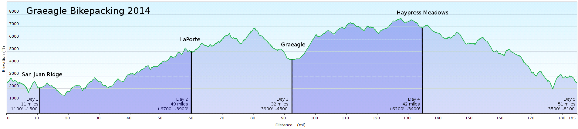
185 miles, 4 days plus an evening, 85 miles or so of dirt road, but no singletrack. Between 21000 and 26000 feet of climb depending on how you calculate it. The goal was to do as much dirt road as possible (and to not use a car).
This was our second bikepacking trip, it looked like we may have bitten off more than we could chew, but it worked out great! Highly recommended for a nice loop around the Sierra Buttes.
Also highly recommended is Johnsville-McRae road from Quincy LaPorte Road (at Gibsonville town site) all the way to Plumas-Eureka State Park (where it becomes paved) and on to Graeagle. Other than that last section of nice fast paved descent, it’s all dirt, but good quality. Bring a good USFS or USGS map and know how to use it, cause there are some turns you wouldn’t want to miss (it’s 25 miles or so of dirt), and a GPS helps for a reality check in some places. We went clockwise and it seemed like that was the right choice – better tread and easier grade for the climbs, chunkier on the descents from McRae Ridge to the end.
We used a TarpTent Squall (disclosure – my girlfriend and ride companion (the artist at bootsmcfarland.com) works for TarpTent – www.tarptent.com – there are other TarpTent reviews on this site – but used a TarpTent for years as a PCT section hiker before getting the job there) – we’ve used it together for several PCT sections over the last several years. It’s a good fit for this type of trip being low bulk and low weight, and you can get extra-beefy poles now too – last year we took a single hiking pole on the bike instead but that was a bit bulkier.
Here’s a folder with the full size map cause apparently clicking on the map below just shows the profile…? and gpx files (one file has one track for the entire route; one file has tracks by tread type) and a kml file – I’m looking for a better way to share those – suggestions?
https://drive.google.com/folderview?id=0B8gs98j-2ZB4Z2VXQ09nNXdnVmM&usp=sharing
Also, here’s a 15 minute video of the trip if you want to see more:
https://drive.google.com/file/d/0B3QkIMm4uY4iYW9sZUFlSmJKWkk/edit?usp=sharing
nice!
I did a Reno -> Fort Bragg trip a month and a half ago with 4 other folks that went from Graeagle to LaPorte over Johnsonville-McRae. We actually turned back at the State Park the first night cause it started snowing (we were hoteling, not camping), and we didn’t wanna get caught in the snow up on the pass.
We managed to hit something like 60% dirt over 4 days. Amazing stuff.
Do you have a gps link?
Snowing up there in May – savor it!
I updated the post with a bit about our tent and a link to the files – enjoy. thanks
-Tom
Also just added a link to a 15 minute video of the trip. Enjoy!
cool, thanks!
Tom thanks for sharing your ride report. This looks like a fun loop that I hope to try some time.
As for sharing the gps info, have you tried ridewithgps.com? The site and the android app have worked great for me. It will allow others to see a map with elevation profiles and download your route in a few different gps friendly formats and will generate downloadable cuesheets too.